
Port Neill, South Australia facts for kids
Quick facts for kids Port NeillSouth Australia |
|||||||||||||||
|---|---|---|---|---|---|---|---|---|---|---|---|---|---|---|---|

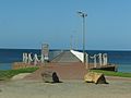
Lady Kinnaird anchor on the foreshore at Port Neill
|
|||||||||||||||

Port Neill
Location in South Australia
|
|||||||||||||||
| Population | 152 (2006 census) | ||||||||||||||
| Established | 1909 | ||||||||||||||
| Postcode(s) | 5604 | ||||||||||||||
| Elevation | 0 m (0 ft) | ||||||||||||||
| Location |
|
||||||||||||||
| LGA(s) | District Council of Tumby Bay | ||||||||||||||
| Region | Eyre Western | ||||||||||||||
| County | Jervois | ||||||||||||||
| State electorate(s) | Flinders | ||||||||||||||
| Federal Division(s) | Grey | ||||||||||||||
|
|||||||||||||||
| Footnotes | Location Adjoining localities |
||||||||||||||
Port Neill (formerly Carrow) is a small town located right on the coast in South Australia. It sits on the eastern side of the Eyre Peninsula. You can find it about 3 kilometers off the Lincoln Highway. The town is between the bigger towns of Whyalla and Port Lincoln. It's about 576 kilometers by road from Adelaide.
Port Neill is known for its calm beaches, perfect for swimming. It's also a great spot for fishing, boating, sailing, skiing, and even skin-diving (diving without special equipment).
Contents
History of Port Neill
Early Explorers and Settlers
The first European to see the area was Matthew Flinders. He sailed past on March 7, 1802. He described the land as "low front land, somewhat sandy," with higher land further inland.
Later, in April 1840, Governor George Gawler and his team explored the coast by horseback. They were the first Europeans to travel through this land between Port Lincoln and the Middleback Ranges. They followed a path similar to today's Lincoln Highway. During this trip, Governor Gawler named Cape Burr and Mount Hill.
The first settlers arrived in 1873. John Tennant and his son Andrew started farming around the bay. At that time, the area was known as Mottled Cove.
Naming the Town
The town was first called Carrow. This name came from an Aboriginal word for a rock hole where water collects. The town was officially recognized in 1903. It was planned out in January 1909 by a surveyor named William Greig Evans.
However, the name 'Carrow' sounded too much like 'Warrow', another place nearby. So, on September 19, 1940, the town was renamed Port Neill. This new name honors Andrew Sinclair Neill, who was a leader on the Marine Board.
The Jetty and Shipping
A jetty is a long pier built into the water. The first jetty in Port Neill was built in 1912. It was used to ship wheat and wool from the farms in the area. Before the jetty, settlers had a hard time getting their goods to ships.
People were very keen for the jetty to be built. Once it was finished, it was said to be the biggest jetty on the Eyre Peninsula. Ships used the jetty until 1970. After that, goods were sent by road to Port Lincoln, which had bigger port facilities.
Geography of Port Neill
Port Neill is located in Mottled Cove, at the southern end of Dutton Bay. It's near Cape Burr on the western side of Spencer Gulf. The town is about 80 kilometers northeast of Port Lincoln. It's also about 40 kilometers northeast of Tumby Bay.
The land around Port Neill is mostly used for farming. The coast has a mix of white, sandy beaches, sand dunes with plants, and rocky areas. In 1909, surveyor William Grieg Evans described the area. He said it had "low mallee teatree and bushes." He also noted "light sandy loam red clay over limestone". He called it "slightly undulating country," meaning the land looked like gentle waves.
Economy and Activities
The old jetty and goods shed in Port Neill show that it was once a busy seaport. Today, Port Neill's economy mostly comes from the farms around it. Farmers grow cereal crops and raise sheep.
Like many towns on the Eyre Peninsula coast, Port Neill is a popular place for tourists. The town gets much busier during the summer holidays. Besides its history, Port Neill offers a relaxed country feel and many fun activities.
Fishing is very popular from the town jetty. You can also fish from the nearby beaches or from boats. There are places to launch boats easily. Other water sports like swimming and snorkelling are great in the clean, sandy bay.
If you want to stay in Port Neill, there are several places to choose from. These include the Port Neill Hotel, a caravan park, and various holiday apartments.
Community Life
Population and People
In 2006, the town of Port Neill had 152 people living there. Another 209 people lived in the surrounding areas. Most people in Port Neill were born in Australia. Those who moved there mostly came from the United Kingdom.
Town Facilities
Port Neill has many sports clubs and fun places to visit. There's an oval for sports, tennis and basketball courts, a bowling green, and a golf course. Kids can enjoy the skatepark and a playground right on the foreshore.
On the foreshore lawns, you can see the anchor from the ship Lady Kinnaird. There's also a World War II cannon. These spots are perfect for family picnics.
In the past, Port Neill had three general stores, a butcher's, a saddler's, a blacksmith's, and a baker's shop. Today, the town has a general store and post office, a hotel and pub, and several shops for tourists. You can also find walking trails, parks, and lookouts around the area.
A small primary school serves the town. It teaches students from Reception (kindergarten) up to Year 7.
Gallery
-
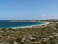
Looking across to Port Neill
-
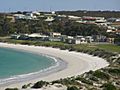
Beach, Port Neill
-
Jetty, Port Neill


