Porth Dafarch facts for kids
Quick facts for kids Porth Dafarch |
|
|---|---|
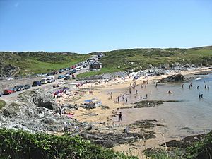
 Beach at Porth Dafarch |
|
| Community | |
| Principal area | |
| Country | Wales |
| Sovereign state | United Kingdom |
| Police | North Wales |
| Fire | North Wales |
| Ambulance | Welsh |
| EU Parliament | Wales |
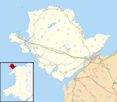
Porth Dafarch is a lovely small bay in North Wales. It's located on the west coast of Anglesey, specifically on Holy Island, Anglesey. This beautiful spot is about 2 miles (3.2 km) southwest of Holyhead. It's also about 1.5 miles (2.4 km) northwest of Trearddur Bay. Porth Dafarch has a sandy beach and is a very popular place for visitors. In 2021, its beach was even given a special award called the Blue Flag beach award. This means it's a clean and safe place to visit!
Contents
What's in a Name? The Meaning of Porth Dafarch
The name "Porth Dafarch" comes from the Welsh language. Its exact meaning isn't completely clear. Some people thought it meant "Harbour of the Two Stallions." However, experts now believe this isn't correct.
The name has changed a bit over time in old documents. It was once called "Porth Davagh" in 1545. Later, it appeared as "Porth Daverch" and "Porth y Dafarch." The name "Porth Dafarch" has been used since 1838. It's thought that "Tafarch" might have been a person's name. This name would change to "Dafarch" after the word "porth" in Welsh.
Exploring the Rocks: Porth Dafarch's Geology
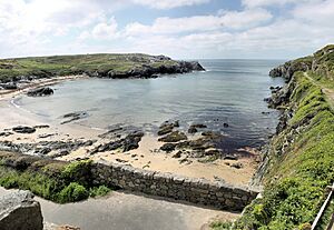
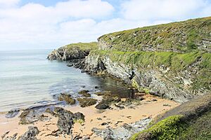
Porth Dafarch bay is about 100 meters wide. It was formed from very old rocks called Precambrian rock. Over many years, the sea has worn away these rocks. This has created tall cliffs and cool sea caves around the bay.
The bay is part of Holy Island, Anglesey. It belongs to a huge group of rocks known as the Monian Supergroup. This is a big geological feature in the area. Porth Dafarch opens out to the southwest, facing the Irish Sea.
A Look Back: The History of Porth Dafarch
Porth Dafarch has an interesting history. From the mid-1600s to the early 1800s, it was an important place. It was used as a backup port when the main port of Holyhead had bad weather. If the sea was too rough at Holyhead, ships would come to Porth Dafarch instead.
Passengers would use this sheltered bay to sail to Dublin in Ireland. But things changed in 1822 when steamships started running. Also, the Holyhead Breakwater was built, making Holyhead a safer port. Because of these changes, Porth Dafarch was no longer needed as an alternative port.
The Old Customs Post
You can still see the old customs post building at Porth Dafarch. It was built in 1819. This building allowed mail and passengers to land on Holyhead Island. This was especially useful when strong winds from the north made it impossible to land at Holyhead. By 1873, the new harbour at Holyhead was finished. This made the customs post unnecessary. The building is now a protected historical site, but it's fenced off because it's in poor condition.
Modern Day Popularity
Today, Porth Dafarch is a very popular place for visitors. People love its sandy beach and enjoy rock-pooling. This is where you explore small pools left by the tide to find sea creatures.
The bay is also a great spot for watersports. Many people come here for windsurfing, surfing, canoeing, sailing, and jet skiing. If you like scuba diving, you can even explore a shipwreck! The Missouri was a large ship that sank here in 1886 while on its way to Boston. Porth Dafarch is also close to campsites and the beautiful Anglesey Coastal Path.
Underwater Cables
An important marine fibre-optic cable comes ashore at Porth Dafarch. This cable links Ireland to the UK. It's called CeltixConnect and has 72 pairs of fibres. The cable was laid over about 30 days, from mid-December 2011 to mid-January 2012. These cables help us connect to the internet and communicate across countries!
 | Toni Morrison |
 | Barack Obama |
 | Martin Luther King Jr. |
 | Ralph Bunche |


