Pratten, Queensland facts for kids
Quick facts for kids PrattenQueensland |
|||||||||||||||
|---|---|---|---|---|---|---|---|---|---|---|---|---|---|---|---|

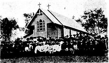
St James' Anglican Church, 1912
|
|||||||||||||||
| Population | 229 (2021 census) | ||||||||||||||
| • Density | 2.428/km2 (6.29/sq mi) | ||||||||||||||
| Postcode(s) | 4370 | ||||||||||||||
| Area | 94.3 km2 (36.4 sq mi) | ||||||||||||||
| Time zone | AEST (UTC+10:00) | ||||||||||||||
| Location | |||||||||||||||
| LGA(s) | Southern Downs Region | ||||||||||||||
| State electorate(s) | Southern Downs | ||||||||||||||
| Federal Division(s) | Maranoa | ||||||||||||||
|
|||||||||||||||
Pratten is a small country town in Queensland, Australia. It is located in the Southern Downs Region. In 2021, about 229 people lived in the area of Pratten.
Contents
Discovering Pratten's Past
Pratten got its name from either Thomas Pratten, an early settler, or his son G.L. Pratten, who was a surveyor. Before it was called Pratten, the area was known as Darkey Flat. This was because it was a place where Aboriginal people often camped.
Early Schools in Pratten
The first school in the area was Darkey Flat State School. It opened its doors in 1876. Later, in 1900, the school's name was changed to Pratten State School. It taught local children for many years before closing in 1965.
Churches and Community Buildings
St James' Anglican Church first opened on July 31, 1881, when the town was still called Darkey Flat.
The Pratten Presbyterian Church was officially opened in 1901. A few years later, in 1905, a new church building was opened. It was called the Patrick Leslie Memorial Presbyterian Church. This church was built to remember Patrick Leslie, an important pioneer from the Warwick area. This church building was later moved to Warwick in 1954. During its journey, it caused a bit of a stir when it slipped off the truck and blocked the Cunningham Highway for a whole day!
The Pratten School of Arts building was opened in 1909. This building was a community hub where people could learn and gather. Today, it is a private home.
Pratten's Population Over Time
The number of people living in Pratten has changed over the years.
- In 2011, there were 363 people living in Pratten.
- By 2016, the population was 205 people.
- In the most recent count in 2021, the population had grown slightly to 229 people.
Learning Opportunities Near Pratten
There are no schools directly in Pratten today. However, students can attend schools in nearby towns.
Primary Schools
For younger students, the closest government primary schools are:
- Wheatvale State School in Wheatvale (to the south-east)
- Leyburn State School in Leyburn (to the north-west)
Secondary Schools
For older students, the nearest government secondary schools are:
- Warwick State High School in Warwick (offers schooling up to Year 12)
- Allora P-10 State School in Allora (offers schooling up to Year 10)
- Clifton State High School in Clifton (offers schooling up to Year 12)
Community Services in Pratten
The Southern Downs Regional Council provides a mobile library service for the community. This library on wheels visits Pratten Hall, making books and resources available to everyone.
St James' Anglican Church is still an important part of the community. You can find it at 42 White Street.
 | Stephanie Wilson |
 | Charles Bolden |
 | Ronald McNair |
 | Frederick D. Gregory |


