
Puerto Escondido, Oaxaca facts for kids
Quick facts for kids
Puerto Escondido
|
|
|---|---|
|
City
|
|

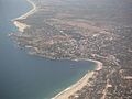
View of Puerto Escondido from the air
|
|

Puerto Escondido
Location in Mexico
|
|
| Country | |
| State | Oaxaca |
| Municipality | San Pedro Mixtepec |
| Area | |
| • City | 12.06 km2 (4.66 sq mi) |
| Elevation | 60 m (200 ft) |
| Population
(2020 census)
|
|
| • City | 29,903 |
| • Density | 2,479.5/km2 (6,421.9/sq mi) |
| Time zone | UTC-6 (CST) |
| Website | Official website: http://www.escondido.com.mx/ |
Puerto Escondido means "Hidden Port" in English. It is a lively port and a popular tourist spot in the state of Oaxaca, Mexico. Before the 1930s, there was no town here. The bay was sometimes used to ship coffee, but people didn't live there permanently because there wasn't enough fresh water.
The name "Puerto Escondido" comes from an old legend about a woman who escaped from her captors and hid in this area. The Nahuatl word for this place was Zicatela, which means "place of large thorns." Today, Zicatela is the name of the area's most famous beach.
Puerto Escondido is one of the most important tourist places on the coast of Oaxaca. It's a favorite for surfers, backpackers, and Mexican families. The main attractions are its beautiful beaches. Zicatela Beach is famous for big surfing competitions, while other beaches have calmer waves perfect for swimming. There's also a large lagoon nearby where you can go fishing and watch many different kinds of birds.
Contents
History of Puerto Escondido
The area around Puerto Escondido was home to native people for many centuries. However, no big towns were built here in ancient times or during the Spanish colonial period. The bay was known as "Bahia de la Escondida," or "Bay of the Hidden Woman." This name comes from a local legend.
The Legend of the Hidden Woman
The story tells of a pirate named Andrés Drake, who was the brother of Sir Francis Drake. He anchored his ship in the bay to rest. Some weeks before, he and his crew had captured a young Mixtec woman from a village called Santa María Huatulco. While in the bay, the woman managed to escape from her prison on the ship. She was a strong swimmer, so she jumped into the water and swam to shore. She then hid in the jungle near the beach.
After that, the pirates called the woman "La Escondida," meaning "the hidden one." Every time their ship returned to these waters, the captain would order his crew to search for her. But they never found her. Because of this story, the area became known as the "Bahía de la Escondida."
From Fishing Village to Port
At the start of the 1900s, this place was called "Punta Escondida" (Hidden Point), and later, Puerto Escondido. It was just a small fishing village. Sometimes, it was used to ship coffee. However, Puerto Escondido didn't have enough fresh drinking water, even though the Colotepec River was nearby. This made it hard for people to settle there.
Still, some people stayed, like Nazario Castellanos and Escolástica Valencia. They were watchmen for nearby coffee farms and are considered the first residents of the town. A real town didn't start to grow until the 1930s, when Puerto Escondido became a more active port.
Growing the Town
From the 1940s to the 1960s, the town started to develop. A church was built, and the first school opened. People dug wells to get more water, and generators were bought to provide electricity. But it was still hard to get supplies like sugar. These goods only arrived when a merchant ship came into the bay, which sometimes didn't happen for months. Residents relied on local foods like fish, chickens, and eggs. This problem got better when a road was built connecting Puerto Escondido to the capital city of Oaxaca.
In the 1960s, Highway 200 was built. This road connected coastal towns like Puerto Escondido to Acapulco. Surfers and other tourists began to discover the quiet beaches, and tourism started to grow. As coffee began to be transported by trucks, Puerto Escondido's role as a port became less important. More improvements were made, including better water supply, a small airport, and mail service. By the 1970s, about 400 people lived in Puerto Escondido.
Over time, Puerto Escondido became more and more popular as a tourist spot. Many hotels and resorts were built. For a long time, most restaurants were simple "palapas" (shelters with thatched roofs) where fishermen cooked their fresh catch. Now, there are many modern tourist places. Puerto Escondido is one of the most important tourist destinations on the Oaxaca coast.
Becoming a City
The community of Puerto Escondido is actually split between two different local governments, called municipalities. One part belongs to Santa María Colotepec, and the other part belongs to San Pedro Mixtepec. The exact border between them has been a bit unclear.
In 2009, the state government officially declared Puerto Escondido a city. This was a big step, but it didn't fully solve the border issues between the two municipalities.
Exploring the City

Puerto Escondido is located on the western part of Oaxaca's coast, often called the Emerald Coast. The bay is surrounded by rocky cliffs that are about 15 to 30 meters high. The main part of the town is on the north side of the bay. The weather here is tropical and humid, with an average temperature of 28°C (82°F). The rainy season is during the summer.
Puerto Escondido is the oldest tourist spot in this area. It's a major hub for visitors from Mexico and other countries. The huge waves at Zicatela Beach make it one of the top ten surfing spots in the world. The port is still used for commercial fishing, and people also come here for deep-sea fishing, especially for sailfish.
Puerto Escondido is not as famous as bigger beach resorts like Acapulco or Cancun. This is partly because it mainly has domestic flights, which means fewer international visitors. Before a new highway opened in 2024, bus trips from the city of Oaxaca took seven hours. The road wound through many turns as it came down the Sierra del Sur mountains.
Puerto Escondido has a relaxed and natural feel. You'll find many small and medium-sized hotels and restaurants. Most of the food is based on fresh seafood and local plants. These include many types of bananas, chocolate, and coffee. There are also some Italian restaurants, started by people who recently moved here from Italy.
El Adoquin: The Heart of Town
The main tourist area in Puerto Escondido isn't a big town square. Instead, it's Pérez Gazga Avenue, which locals call "El Adoquin" or "La Zona Adoquinada." This means "the paving stone street." Along this street, you'll find bars, hotels, cafes, restaurants, nightclubs, and craft shops. There are also internet cafes, small stores, and places to book tours or rent scuba diving gear.
El Adoquin runs along the main beach and is a great place to walk. After 5 PM, it becomes a pedestrian-only street. At night, it's full of both locals and tourists. This is a good spot to buy Mexican handicrafts, especially items from Oaxaca. You can find blouses, shirts, bags, hammocks, carved stone jewelry, and silver items. However, for the best prices, you should visit the main market in the town center.
Scenic Walkway
The Andador Escénico, or Scenic Walkway, is a series of paths, stairs, and bridges. It starts at the main beach and winds along the rocky cliffs by the ocean. It goes past the lighthouse and leads to a viewpoint called Sueño Posible (Possible Dream). In some spots, the walkway is very close to the ocean, and waves might splash you!
Carnival Fun
Every year, Puerto Escondido celebrates Carnival. The festivities begin with a tradition called "quema de mal humor," which means "the burning of bad mood." People burn a figure to get rid of bad thoughts and feelings. This helps everyone enjoy the celebrations with a happy spirit!
Education
The Universidad del Mar has one of its campuses in Puerto Escondido.
Amazing Beaches
The main reason people visit Puerto Escondido is its incredible beaches. They are known all over the world. The area is also popular for scuba diving. You can see many different fish, large oysters, lobsters, and manta rays here. The Pacific Coast of Mexico usually runs north-south, but this part of the Oaxaca coast runs east-west. Zicatela Beach is on the eastern end.
Zicatela Beach: Surfer's Paradise
Puerto Escondido became famous for the surfing competitions held at Zicatela Beach every November. Surfers from many countries come to compete. This beach is nicknamed the "Mexican Pipeline." This is because its waves are as powerful and shaped like the famous Banzai Pipeline in Hawaii. The waves at Zicatela Beach attract surfers and bodyboarders from all over the world.
Mid to late summer is a quieter time for regular tourists, but it's the best time for big waves and international surfing tournaments. Major competitions like the ESPN X Games and the MexPipe Challenge have taken place here. A rocky area called "El Morro" (the nose) separates Zicatela from the other beaches. Zicatela Beach is 50 to 100 meters wide and four kilometers long. Its huge waves can reach up to sixteen meters high!
Lifeguards are always on duty at this high-risk beach, as well as on the other beaches. About half of them are professionals, and the rest are volunteers. Zicatela is still mainly a surfers' beach. The strong rip currents here make it unsafe for swimming. The Zicatela Beach tourist area has many shops and services for surfers, including surfboard rentals. The beach now has a nice promenade with flowers and shrubs along the restaurants.
Calmer Waters: Marinero and Principal Beaches
West of Zicatela, past the El Moro rocky outcrop, is Playa Marinero. This is the best beach for swimming because the waves and rip currents are much weaker. There are still some waves, but they are gentle enough for beginner surfers and bodyboarding.

West from Playa Marinero is Playa Principal, which means "main beach." This beach is right in front of the town. You'll see boats and water taxis anchored close to shore. Early in the morning, fishermen arrive here to sell their fresh catch to local restaurants and families. It's 500 meters long with soft, gray sand and small to medium waves.
This is the main place to hire boats. You can take a boat to other beaches that are hard to reach by land. You can also go out to see dolphins and sea turtles, or try deep-sea fishing. Playa Principal is also a popular spot for Mexican families to have picnics and play soccer.
Hidden Coves: Angelito, Manzanillo, and Carrizalillo

West of Playa Principal is the lighthouse, with the stone walkway, Andador Escénico, below it. A bit farther west are the two beaches of Puerto Angelito and Manzanillo. They are separated by a small rocky area. These beaches are in a sheltered cove, which makes the water safe for swimming. Manzanillo has slightly bigger waves than Angelito.
Puerto Angelito Beach has small, family-owned restaurants in palapas (open-air thatched structures). The water at these beaches changes color from emerald green to turquoise blue. Puerto Angelito can get crowded, especially with busloads of visitors. Playa Manzanillo is quieter because there's no road access to it.

West from these beaches is Playa Carrizalillo. It has white sand and beautiful cobalt blue water with light green edges. This beach is about 300 meters wide and sits in a small bay. You can't drive to this beach. You have to walk down a steep path with recently built rock stairs. It takes about fifteen minutes to walk here from town. Another way to get to Carrizalillo is by taking a water taxi from Playa Principal.
The waves here are usually gentle. However, there's one area that opens directly to the ocean where the waves are big enough for surfing. Because it's harder to reach, this beach isn't as crowded with vendors as Puerto Angelito. There are only a few restaurants, and the area is generally cleaner. On both sides of the bay are rocky areas. These are home to many different fish and coral, making it a great spot for snorkeling. Near Carrizalillo is the Rinconada, which used to be an airport runway. Now, it's full of restaurants, salons, and shops. It also has a lending library run by a local charity.
Relaxing at Bacocho Beach
The westernmost beach is Playa Bacocho. This beach has more upscale beach clubs. It has soft, fine sand, palm trees, and warm, blue-green water. The waves are moderate, but the far western part of the beach can have a strong rip current. It faces southwest, so it's a perfect spot to watch the sunset. West of Bacocho, there are still undeveloped beaches.
Getting Around Puerto Escondido
Puerto Escondido International Airport has flights to the cities of Oaxaca, Monterrey, and Mexico City.
Commercial buses from the city of Oaxaca usually take about seven hours to reach Puerto Escondido.
A new three-lane highway, called a "supercarretera," has been built from Oaxaca. It connects to the old coastal Highway 200 about 13 kilometers east of Puerto Escondido. This project took over ten years to complete. It opened in 2024 and reduces the travel time from Oaxaca to about two and a half hours.
Local Media
Puerto Escondido has both AM and FM radio stations. There are also Spanish language weekly newspapers. ¡Viva Puerto! (http://vivapuerto.com) is a local magazine that is published in both English and Spanish.
November Festivals
The Fiestas de Noviembre (Festivals of November) are held during November and into early December. Events are planned in both the San Pedro Mixtepec and Santa María Colotepec areas. This means there are usually many events happening, sometimes at the same time! Events on Zicatela Beach are often held right on the sand. Events in the uptown area are often on Playa Principal or in the municipal plaza. Some of the main events include a motocross race, a sailfishing competition, a festival of coastal dance, and a surfing tournament.
Laguna de Manialtepec: Nature's Beauty
About 10 kilometers west of Puerto Escondido is the Laguna de Manialtepec. On the way, you'll pass a small village called Bajos de Chila. There's also a small archaeological site from the Chatino culture here. This site has a Sun Stone, which represented the solar deity, and a statue of an important priest.
The lagoon is filled with mangroves and is home to many birds. You can see pelicans, seagulls, ibis, storks, cranes, jacanas, buzzards, kingfishers, and swans. Other animals that live here include raccoons, weasels, deer, wild boar, foxes, and crocodiles. In the middle of the lagoon is an island called Isla del Gallo, or "Rooster Island." Legend says that a rooster can be heard singing there every year on December 24th.
Images for kids
-
View of Puerto Escondido from the air
See also
 In Spanish: Puerto Escondido (Oaxaca) para niños
