Purga, Queensland facts for kids
Quick facts for kids PurgaQueensland |
|||||||||||||||
|---|---|---|---|---|---|---|---|---|---|---|---|---|---|---|---|

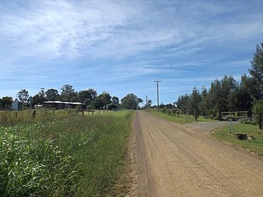
Hughes Road, 2015
|
|||||||||||||||
| Population | 561 (2021 census) | ||||||||||||||
| • Density | 9.912/km2 (25.67/sq mi) | ||||||||||||||
| Postcode(s) | 4306 | ||||||||||||||
| Area | 56.6 km2 (21.9 sq mi) | ||||||||||||||
| Time zone | AEST (UTC+10:00) | ||||||||||||||
| Location |
|
||||||||||||||
| LGA(s) | City of Ipswich | ||||||||||||||
| State electorate(s) |
|
||||||||||||||
| Federal Division(s) | Blair | ||||||||||||||
|
|||||||||||||||
Purga is a small, quiet area in the countryside of Queensland, Australia. It's located southwest of the city of Ipswich. In 2021, about 561 people lived in Purga. It's known for its open spaces and a bit of history.
Contents
Exploring Purga's Geography
Purga is found on the edge of the city of Ipswich. It has a natural border on its western side, which is a creek called Warrill Creek.
Purga's Waterways
Another important creek, Purga Creek, flows into the area from the south. It then travels north and leaves Purga. This creek eventually joins Warrill Creek.
Major Roads in Purga
The Cunningham Highway passes through Purga, entering from the north and heading west. Another main road, Ipswich – Boonah Road, comes from the northeast. It runs south through Purga before exiting to the southeast.
Land Use in Purga
Most of the land in Purga is used for grazing. This means it's used for animals like cattle to eat grass.
A Look at Purga's History
The name "Purga" comes from an Aboriginal word, pur-pur. This word means "a meeting place."
Early Schools in Purga
Purga Creek State School opened a long time ago, on 1 September 1871. It later changed its name to Purga State School around 1945. This school closed its doors in 1967. It was located on Purga School Road.
Another school, Deebing Creek Provisional School, started on 21 January 1895. In 1924, it became Purga Aboriginal State School. This school closed around 1948. It was located within an Aboriginal reserve.
Purga's Railway Past
People living in the Fassifern Valley area asked the government for a railway line. The first part of the Dugandan railway line opened on 10 July 1882. This line went as far as Harrisville. It was Queensland's first "branch railway," which means it was a smaller line connected to a main one.
Purga had three railway stations:
- Loamside railway station
- Hampstead railway station
- Purga railway station
All these stations were on the Ipswich Boonah Road. The railway line was extended further in 1887. However, the entire line closed in 1964.
Who Lives in Purga?
The number of people living in Purga has changed a little over the years.
- In 2011, Purga and nearby areas had about 600 people.
- By 2016, Purga's population was 576 people.
- In the most recent count in 2021, 561 people lived in Purga.
Important Heritage Sites
Purga has a few special places that are listed as heritage-listed sites. This means they are important historical locations.
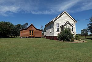
- Purga United Church: This church is located on Purga School Road.
- Purga Aboriginal Cemetery: This cemetery is found on Carmichaels Road.
Education in Purga
Currently, there are no schools located directly in Purga. Children living in Purga attend schools in nearby areas.
Primary Schools for Purga Kids
For primary school, students usually go to Amberley District State School. This school is in Yamanto, which is to the northeast of Purga. Another option is Peak Crossing State School, located to the south in Peak Crossing.
Secondary Schools for Purga Teens
For high school, students typically attend Bremer State High School. This school is located in the Ipswich CBD, which is further to the northeast.
Local Facilities
Purga has a sewage treatment plant. This plant helps to clean wastewater from homes and businesses. It is located on the Cunningham Highway.
 | Chris Smalls |
 | Fred Hampton |
 | Ralph Abernathy |


