
Rainbow City, Alabama facts for kids
Quick facts for kids
Rainbow City, Alabama
|
|||
|---|---|---|---|
|
City
|
|||
| City of Rainbow City | |||
|
|||

Location of Rainbow City in Etowah County, Alabama
|
|||
| Country | United States | ||
| State | Alabama | ||
| County | Etowah | ||
| Area | |||
| • Total | 25.92 sq mi (67.13 km2) | ||
| • Land | 25.58 sq mi (66.25 km2) | ||
| • Water | 0.34 sq mi (0.88 km2) | ||
| Elevation | 518 ft (158 m) | ||
| Population
(2020)
|
|||
| • Total | 10,191 | ||
| • Density | 398.41/sq mi (153.83/km2) | ||
| Time zone | UTC-6 (Central (CST)) | ||
| • Summer (DST) | UTC-5 (CDT) | ||
| ZIP codes |
35901, 35906
|
||
| Area code(s) | 256 | ||
| FIPS code | 01-63288 | ||
| GNIS feature ID | 2404588 | ||


Rainbow City is a city in Etowah County, Alabama. It became a city in 1950. In 2020, about 10,191 people lived there. It's part of the larger Gadsden area.
Contents
History of Rainbow City
Rainbow City got its name from U.S. Highway 411, also known as Rainbow Drive. This important road goes right through the middle of the city.
The first visitors to this area were the troops of Hernando de Soto in 1540. Later, in 1818, families from the Carolinas and Georgia moved here. They settled near the Coosa River and called the area "Coosa Bend." This place was later known as "Morgan's Cross Road." It was at the spot where the Gadsden-Ashville Road met Gilbert's Ferry Road.
John Sheffield Jones was the grandson of one of the first settlers. He gave money and land to build the first John S. Jones Elementary School. This school later burned down. A new elementary school was built and still serves the Rainbow City area today.
In 1831, a church was started at the Harmony Meeting House. A few years later, the first Baptist association was formed. Harmony was one of the first five churches in this group. The old cemetery next to it, Old Harmony Cemetery, is now a historic landmark.
Education in Rainbow City
The Etowah County Board of Education manages the schools in the city. Rainbow City has one public elementary school. It shares a middle school and a high school with the nearby city of Southside. There is also a private school in Rainbow City.
John S. Jones Elementary School
John S. Jones is one of the elementary schools in the area. It teaches students from kindergarten to fifth grade.
Southside High School
Southside High School is shared by students from Southside and Rainbow City. It serves students in grades 9 through 12.
Westbrook Christian School
Westbrook Christian School is a private school. It teaches students from pre-kindergarten all the way through 12th grade.
Geography of Rainbow City
Rainbow City is located in the southern part of Etowah County. It is next to Gadsden, which is the county seat, on its northeast side. The Coosa River is to its southeast, and across the river is the city of Southside. To the southwest, across Little Canoe Creek, is the town of Steele in St. Clair County.
U.S. Route 411 (Rainbow Drive) is the main road in the city. It goes northeast about 6 miles to the center of Gadsden. It also goes southwest about 15 miles to Ashville. Alabama State Route 77 (Grand Avenue) crosses US 411 in the middle of Rainbow City. It leads northwest about 4 miles to Interstate 59 and south about 26 miles to Lincoln.
The U.S. Census Bureau says that Rainbow City covers about 25.9 square miles (67.1 square kilometers). Most of this area, about 25.5 square miles (66.2 square kilometers), is land. The rest, about 0.34 square miles (0.88 square kilometers), is water.
Population of Rainbow City
| Historical population | |||
|---|---|---|---|
| Census | Pop. | %± | |
| 1960 | 1,625 | — | |
| 1970 | 3,107 | 91.2% | |
| 1980 | 6,299 | 102.7% | |
| 1990 | 7,673 | 21.8% | |
| 2000 | 8,428 | 9.8% | |
| 2010 | 9,602 | 13.9% | |
| 2020 | 10,191 | 6.1% | |
| U.S. Decennial Census | |||
In 2020, there were 10,191 people living in Rainbow City. There were 3,847 households and 2,508 families.
People Living in Rainbow City
| Race | Num. | Perc. |
|---|---|---|
| White (non-Hispanic) | 7,984 | 78.34% |
| Black or African American (non-Hispanic) | 1,113 | 10.92% |
| Native American | 24 | 0.24% |
| Asian | 323 | 3.17% |
| Pacific Islander | 7 | 0.07% |
| Other/mixed | 458 | 4.49% |
| Hispanic or Latino | 282 | 2.77% |
In 2010, about 87.4% of the people were White. About 7.2% were Black or African American. About 2.6% were Asian. People of Hispanic or Latino background made up about 2.4% of the population.
The average age of people in the city in 2010 was 40.5 years old. About 22.9% of the population was under 18. About 16.8% of the population was 65 or older.
Transportation in Rainbow City
Etowah County Rural Transportation offers bus service throughout Rainbow City and the county. This is a "dial-a-ride" service, meaning you can call to arrange a ride.
Notable People from Rainbow City
- Brodie Croyle: A former quarterback for the Alabama Crimson Tide and a retired NFL player.
- Patrick Nix: A former quarterback for the Auburn Tigers and a current high school football coach.
Images for kids
-
The flag of Rainbow City.
-

The official logo of Rainbow City.
-
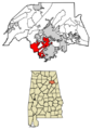
A map showing Rainbow City's location in Etowah County.
See also
 In Spanish: Rainbow City (Alabama) para niños
