
Rancho Santa Margarita, California facts for kids
Quick facts for kids
Rancho Santa Margarita, California
|
|||
|---|---|---|---|

Rancho Santa Margarita
|
|||
|
|||

Location of Rancho Santa Margarita within Orange County, California.
|
|||

Rancho Santa Margarita, California
Location in the United States
|
|||
| Country | United States | ||
| State | California | ||
| County | Orange | ||
| Incorporated | January 1, 2000 | ||
| Government | |||
| • Type | Council-Manager | ||
| Area | |||
| • Total | 12.94 sq mi (33.52 km2) | ||
| • Land | 12.90 sq mi (33.40 km2) | ||
| • Water | 0.05 sq mi (0.12 km2) 0.27% | ||
| Elevation | 925 ft (282 m) | ||
| Population
(2020)
|
|||
| • Total | 47,949 | ||
| • Density | 3,714.02/sq mi (1,435.60/km2) | ||
| Time zone | UTC-8 (Pacific) | ||
| • Summer (DST) | UTC-7 (PDT) | ||
| ZIP codes |
92679, 92688
|
||
| Area code | 949 | ||
| FIPS code | 06-59587 | ||
| GNIS feature IDs | 1867054, 2411517 | ||


Rancho Santa Margarita is a city in Orange County, California, United States. It is one of Orange County's newest cities. Rancho Santa Margarita is a master-planned community, which means it was carefully designed before being built. In 2020, about 47,949 people lived there.
This city has the longest name in California, with 20 letters. It is named after a historic ranch called Rancho Santa Margarita y Las Flores. However, the city itself is located within the borders of a different ranch, Rancho Mission Viejo.
Contents
History of Rancho Santa Margarita

The land where Rancho Santa Margarita is today was originally home to the Acjachemen people. Their village, called Alume, was located here. In 1810, a building called the Trabuco Adobe was built near the village. It served as an outpost for Mission San Juan Capistrano.
The city's official seal shows symbols from two old ranches: Rancho Mission Viejo and Rancho Santa Margarita y Las Flores. It also features Santiago Peak in the background and the Rancho Santa Margarita Lake Tower.
A company called Hughes Aircraft Company had a microelectronics factory in Rancho Santa Margarita starting in 1988. However, it closed in 1992 and moved away.
Rancho Santa Margarita became an official city on January 1, 2000. Before that, Rolling Hills Estates had the longest city name in California. But when Rancho Santa Margarita became a city, it took that title because its name is one letter longer.
The city is run by a Council-Manager type of government. This means a city council makes decisions, and a city manager handles the daily operations. Rancho Santa Margarita is also a "contract city." This means it pays other organizations to provide services. For example, the Orange County Sheriff's Department provides police services, and the Orange County Fire Authority handles fire protection.
Geography of Rancho Santa Margarita
Rancho Santa Margarita is located at 33°38′29″N 117°35′40″W / 33.64139°N 117.59444°W. It sits on a high flat area known as Plano Trabuco.
The city covers about 13.0 square miles (33.52 square kilometers). Most of this area is land, with a small part (about 0.27%) being water.
Rancho Santa Margarita is surrounded by other places. To the west is the city of Mission Viejo. To the south are Coto de Caza and Las Flores. To the north is the area of Trabuco Canyon. To the east, you'll find the Cleveland National Forest.
You can get to Rancho Santa Margarita by car using California State Route 241, which is a toll road. Other main roads in the city include Santa Margarita Parkway and Antonio Parkway. Smaller roads like Avenida De Las Banderas and Avenida Empresa also help people get around. Alicia Parkway also ends in the city, connecting it to Mission Viejo.
Communities in Rancho Santa Margarita
Most neighborhoods in Rancho Santa Margarita are managed by large homeowners associations. These groups help maintain common areas and set rules for the community. Some of the main associations include SAMLARC, Dove Canyon, Rancho Cielo, Robinson Ranch, Walden, and Trabuco Highlands. Many of these communities existed before Rancho Santa Margarita became an official city.
Even though some areas are within the city limits of Rancho Santa Margarita, they might have a Trabuco Canyon zip code (92679). This is true for areas east of Plano Trabuco Road.
Climate in Rancho Santa Margarita
Rancho Santa Margarita has a Mediterranean climate. This means it generally has mild, wet winters and warm, dry summers, similar to many other parts of southern California.
Economy and Jobs
Top Employers in the City
Many people work in Rancho Santa Margarita. Here are some of the biggest employers in the city, based on a 2020 report:
| # | Employer | # of employees |
|---|---|---|
| 1 | Applied Medical | 2,700 |
| 2 | O'Connell Landscape Maintenance | 1,000 |
| 3 | Saddleback Valley Unified School District | 288 |
| 4 | Target | 255 |
| 5 | Lucas & Mercier Construction | 250 |
| 6 | Capistrano Unified School District | 215 |
| 7 | Control Components Inc. | 200 |
| 8 | PADI | 180 |
| 9 | Santa Margarita Catholic High School | 175 |
| 10 | Car Sound Exhaust System | 150 |
Population of Rancho Santa Margarita
| Historical population | |||
|---|---|---|---|
| Census | Pop. | %± | |
| 1990 | 11,390 | — | |
| 2000 | 47,214 | 314.5% | |
| 2010 | 47,853 | 1.4% | |
| 2020 | 48,119 | 0.6% | |
| U.S. Decennial Census | |||
Population in 2020
The 2020 United States Census counted 48,119 people living in Rancho Santa Margarita.
Population in 2010
In 2010, the population of Rancho Santa Margarita was 47,853. The city had about 3,683 people per square mile.
Many people in Rancho Santa Margarita have a college degree. About 31.8% of the population had a bachelor's degree, and 16.4% had a graduate or professional degree. This is higher than the average for California.
In 2010, almost everyone (100%) lived in homes. There were 16,665 households in the city. About 46.2% of these households had children under 18 living there. Many households (60.9%) were married couples. The average household had 2.87 people.
The population was spread out by age:
- 29.0% were under 18 years old.
- 7.9% were between 18 and 24 years old.
- 28.6% were between 25 and 44 years old.
- 28.8% were between 45 and 64 years old.
- 5.7% were 65 years or older.
The average age in the city was 36.0 years.
Most homes (71.4%) were owned by the people living in them, while 28.6% were rented.
Education in Rancho Santa Margarita
Students in Rancho Santa Margarita attend schools in two different school districts: the Saddleback Valley Unified School District (SVUSD) and the Capistrano Unified School District (CUSD).
- High school students in the SVUSD area go to Trabuco Hills High School or Mission Viejo High School. Both of these schools are located in the nearby city of Mission Viejo.
- Students in the CUSD area attend Tesoro High School, which is in the Las Flores neighborhood.
- For middle school, students attend Rancho Santa Margarita Intermediate School (SVUSD) or Las Flores Middle School (CUSD).
- Public elementary schools in the city include Cielo Vista, Trabuco Mesa, Robinson Ranch, Arroyo Vista, Melinda Heights, and Tijeras Creek.
- There are also private elementary and middle schools like St. John's Episcopal Day School, Serra Catholic, and Mission Hills Christian School.
- Santa Margarita Catholic High School is a private Roman Catholic high school located right in Rancho Santa Margarita.
Notable People from Rancho Santa Margarita

Many famous people have lived in or are from Rancho Santa Margarita:
- Jonathon Blum (born 1989), a professional ice hockey player who played in the National Hockey League and the 2018 Winter Olympics.
- Joy Fawcett, an Olympic gold medalist in soccer.
- Joshua Fuentes, a professional baseball player.
- Warren G, a well-known rapper and music producer.
- Carson Palmer, a former American football player who attended Santa Margarita Catholic High School.
- Mark Sanchez (born 1986), a former National Football League quarterback.
- Teemu Selänne, a famous ice hockey player.
- Klay Thompson, a professional basketball player who also attended Santa Margarita Catholic High School.
- Members of the band Movements.
- Members of the rock band Velvet Revolver.
Images for kids
-
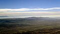
Rancho Santa Margarita
-

Flag of Rancho Santa Margarita
-
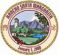
Seal of Rancho Santa Margarita
-
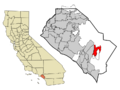
Location of Rancho Santa Margarita within Orange County, California.
See also
 In Spanish: Rancho Santa Margarita para niños
