
Reasi facts for kids
Quick facts for kids
Reasi
Rasyal
|
|
|---|---|

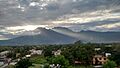
Skyline of Reasi town, J&K from rooftop.
|
|
| Nickname(s):
Gateway of Chenab Railway Bridge
|
|

Reasi
Location in Jammu and Kashmir

Reasi
Location in India
|
|
| Country | |
| Union Territory | |
| District | Reasi |
| Elevation | 466 m (1,529 ft) |
| Population
(2011)
|
|
| • Total | 36,355 |
| Demonym(s) | Reasian, Reasiya, Rasyali, Rasyalia |
| Languages | |
| • Official | Dogri,Gojri, Hindi |
| • Other | Pahari, Gojri |
| Time zone | UTC+5:30 (IST) |
| Vehicle registration | JK-20 |
Reasi is a town located in the Reasi district of Jammu and Kashmir, India. It sits right by the Chenab River. Reasi is also the main office for the Reasi district. Long ago, in the 8th century, Reasi was part of a state called Bhimgarh. This state was started by a Rajput king named Bhim Dev Rasyal. The name Reasi comes from its old name, "Rasyal."
Contents
Geography and Climate
Reasi is found at 33°05′N 74°50′E / 33.08°N 74.83°E. It is about 466 meters (1,529 feet) above sea level.
Reasi District Overview
The Reasi district is about 64 kilometers away from Jammu. Many people here earn a living from small businesses, government jobs, and farming. Out of 12,293 hectares of farmland, 1,011 hectares get water for crops. The main crops grown are maize, wheat, paddy, and bajra. People also grow vegetables.
Most of the area has a warm climate, like a subtropical zone. Higher parts of the district have a cooler climate, like a temperate zone. Summers are usually warm, and winters are cold. It can even snow in the higher areas.

A Look Back: Reasi's History
The area we now call Reasi was once known as the Bhimgarh State. It was founded by Bhim Dev in the 8th century. We know more about its rulers starting from 1652, when Hari Dev was the king of Jammu.
In 1810, when Diwan Singh was in charge, Jammu faced many problems. There were fights within the palace and rebellions. Because of this, Maharaja Ranjit Singh sent Gulab Singh to take control. Gulab Singh stopped the rebels and brought order back. After he defeated the rebels in Reasi, he gave control of the area to his trusted commander, General Zorawar Singh.
In 2005, Reasi held its first local elections. Mr. Kuldeep Mengi was chosen as the first chairman of the town's local government.
In September 2014, there were very bad floods. A village called Saddal in the Reasi district was hit hard by a landslide. All the roads leading to the town were covered.
In 2024, a bus carrying people visiting a Hindu religious site was attacked. Nine people died and 41 were hurt in this event.
People and Languages
Religion in Reasi City (2011) Hinduism (85.74%) Islam (10.66%) Sikhism (0.05%) Christianity (3.5%) Not Stated (0.05%)
According to the census from As of 2011[update], Reasi had 36,355 people living there. About 54% were males and 46% were females. Reasi has a good literacy rate of 75%, which is higher than the national average of 59.5%. This means 78% of males and 70% of females can read and write. About 13% of the people in Reasi are under 6 years old.
Reasi district has 177 villages. The total area is 74,932 square kilometers, and about 71,501 people live there. The main languages spoken are Dogri, Hindi, Urdu, Gojri, and Kashmiri.
Religions in Reasi
Most people in Reasi follow Hinduism, about 85.74%. About 10.66% of people follow Islam. Smaller groups follow Christianity (3.5%) and Sikhism (0.05%).
Places to Visit
Reasi has many interesting places to see, along with its beautiful natural surroundings. Some popular spots include:
- Mata Vaishnodevi
- Bhumika Temple
- Deva Mai
- Nau Pindian
- Baba Dhansar
- Bhimgarh Fort
- Kalika Temple
- Sula Park
- Sihar Baba
- Shivkhori

Getting Around Reasi
Reasi is only 64 kilometers from Jammu city. You can get there by road, train, or air. The closest airport is Jammu Airport, which is about 80 kilometers away. The nearest train station is Shri Vaishno Devi Katra railway station, about 26 kilometers away. There is also a planned train station called Reasi railway station that will be part of the Jammu-Baramulla railway line.
Natural Resources
Reasi is rich in natural resources. It has deposits of bauxite (used to make aluminum), iron, and valuable stones.
In 2023, the Geological Survey of India found a large amount of lithium in the region. They estimate there are 5.9 million tonnes of lithium, which is a very important metal for batteries.
Reasi Today
Because Reasi is far from the main Jammu - Udhampur Highway and is in a hilly area, its economic growth was slow for a while. However, things started to improve in the 1980s when the Salal Hydroelectric Project was built. This project helped create jobs and bring more activity to the area.
Even though there were challenges in the 1990s, the presence of the Army has helped people feel safer. A big change that will likely bring a lot of development to Reasi is the Jammu - Srinagar Railway Line. This railway line will pass through Reasi, which is expected to bring much progress and wealth to the area. Once this project is finished, Reasi is set to grow a lot. Most major banks now have branches in Reasi to help with the financial needs of this newly formed district.
World's Highest Railway Bridge
Reasi is home to the world's highest railway bridge, the Chenab Bridge. This amazing bridge is 359 meters high and was built by Konkan Railways. It is even taller than the Millau Viaduct (323 meters) in southern France.
Images for kids
-
Skyline of Reasi town, J&K from rooftop.
-
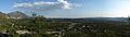
Reasi skyline in summer
-
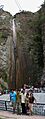
Sihar Baba Waterfall in Summer
See also
 In Spanish: Reasi para niños
