Alloway Township, New Jersey facts for kids
Quick facts for kids
Alloway Township, New Jersey
|
||
|---|---|---|
|
Township
|
||
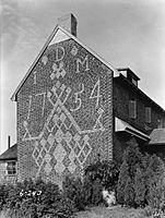
Dickenson House
|
||
|
||
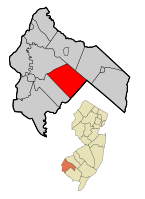
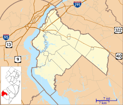
Alloway Township highlighted in Salem County. Inset map: Salem County highlighted in the State of New Jersey.
|
||
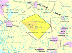
Census Bureau map of Alloway Township, New Jersey
|
||
| Country | ||
| State | ||
| County | ||
| Royal charter | June 17, 1767, as Upper Alloways Creek Township | |
| Incorporated | February 21, 1798 | |
| Renamed | February 21, 1884, as Alloway Township | |
| Named for | Native American Chief Alloway | |
| Government | ||
| • Type | Township | |
| • Body | Township Committee | |
| Area | ||
| • Total | 33.91 sq mi (87.84 km2) | |
| • Land | 33.48 sq mi (86.70 km2) | |
| • Water | 0.44 sq mi (1.13 km2) 1.29% | |
| Area rank | 71st of 565 in state 6th of 15 in county |
|
| Elevation | 62 ft (19 m) | |
| Population
(2020)
|
||
| • Total | 3,283 | |
| • Estimate
(2023)
|
3,319 | |
| • Rank | 435th of 565 in state 9th of 15 in county |
|
| • Density | 98.1/sq mi (37.9/km2) | |
| • Density rank | 542nd of 565 in state 10th of 15 in county |
|
| Time zone | UTC−05:00 (Eastern (EST)) | |
| • Summer (DST) | UTC−04:00 (Eastern (EDT)) | |
| ZIP Code |
08001
|
|
| Area codes | 856 exchanges: 339, 878, 935 | |
| FIPS code | 3403300880 | |
| GNIS feature ID | 00882131 | |
| Website | ||
Alloway Township is a community located in Salem County, New Jersey. It's known as a township, which is a type of local government area in New Jersey. In 2020, about 3,283 people lived here.
Contents
History of Alloway Township
Alloway Township has a long history. It was first officially recognized as Upper Alloways Creek Township on June 17, 1767. This happened through a special document called a Royal charter.
The township became a fully official local government on February 21, 1798. Later, on February 18, 1873, a part of the township became its own area called Quinton Township. The name was officially changed to Alloway Township on February 21, 1884.
The name "Alloway" comes from a local Native American chief named Allowas.
Ranch Hope: Helping Kids in Alloway
Ranch Hope is a special organization in Alloway Township. It was started in 1962 by Reverend David L. Bailey Sr. and Eileen Bailey. This group helps thousands of children and families each year. They offer support for health, education, and even short-term housing. Ranch Hope is located on a large 100-acre campus in the township.
Geography and Location
Alloway Township covers about 33.91 square miles (87.84 square kilometers). Most of this area is land, with a small part being water.
Communities Within Alloway
The main community within the township is called Alloway. Other smaller communities and places in the township include:
- Aldine
- Alloway Junction
- Dilkes Mile
- Friesburg
- Lake Sycamore
- Mower
- New Boston
- Oakland
- Penton
- Remsterville
- Riddleton
- Watsons Mills
Neighboring Towns
Alloway Township shares its borders with several other townships. In Salem County, it borders Mannington Township, Pilesgrove Township, Quinton Township, and Upper Pittsgrove Township. It also borders Hopewell Township, Stow Creek Township, and Upper Deerfield Township in Cumberland County.
Population Changes Over Time
| Historical population | |||
|---|---|---|---|
| Census | Pop. | %± | |
| 1810 | 1,921 | — | |
| 1820 | 2,194 | 14.2% | |
| 1830 | 2,136 | −2.6% | |
| 1840 | 2,235 | 4.6% | |
| 1850 | 2,530 | 13.2% | |
| 1860 | 2,899 | 14.6% | |
| 1870 | 3,062 | 5.6% | |
| 1880 | 1,917 | * | −37.4% |
| 1890 | 1,675 | −12.6% | |
| 1900 | 1,528 | −8.8% | |
| 1910 | 1,533 | 0.3% | |
| 1920 | 1,431 | −6.7% | |
| 1930 | 1,575 | 10.1% | |
| 1940 | 1,705 | 8.3% | |
| 1950 | 1,792 | 5.1% | |
| 1960 | 2,226 | 24.2% | |
| 1970 | 2,550 | 14.6% | |
| 1980 | 2,680 | 5.1% | |
| 1990 | 2,795 | 4.3% | |
| 2000 | 2,774 | −0.8% | |
| 2010 | 3,467 | 25.0% | |
| 2020 | 3,283 | −5.3% | |
| 2023 (est.) | 3,319 | −4.3% | |
| Population sources: 1810–2000 1810–1920 1840 1850–1870 1850 1870 1880–1890 1890–1910 1910–1930 1940–2000 2000 2010 2020 * = Lost territory in previous decade. |
|||
The population of Alloway Township has changed over the years. In 2010, there were 3,467 people living here. By 2020, the population had slightly decreased to 3,283.
Who Lives in Alloway?
In 2010, the township had 1,193 households. About 34.5% of these households had children under 18 years old. Most households (67.6%) were married couples living together.
The average household had 2.84 people. About 26.2% of the population was under 18 years old. About 11.9% of the population was 65 years or older. The average age in the township was 40.1 years.
Education in Alloway
Students in Alloway Township attend public schools through two different districts.
Elementary and Middle School
Younger students, from pre-kindergarten through eighth grade, attend the Alloway Township School District. There is one school, Alloway Township School. In the 2021–2022 school year, about 289 students were enrolled. There were 25.2 teachers, meaning about 11.5 students per teacher.
High School Education
For high school, students in ninth through twelfth grades go to Woodstown High School in Woodstown. This high school also serves students from other nearby townships like Pilesgrove, Oldmans, and Upper Pittsgrove. In the 2021–2022 school year, Woodstown High School had 559 students and 49.7 teachers. This means there were about 11.2 students for every teacher.
Getting Around: Transportation
As of 2010, Alloway Township had about 79.86 miles of roads. The local government maintained 36.66 miles of these roads. Salem County maintained the other 43.20 miles.
Main Roads in Alloway
Several important roads pass through Alloway Township:
- New Jersey Route 77 (also known as Pole Tavern-Bridgeton Road) goes through the eastern part of the township.
- County Route 540
- County Route 581
Notable People
Here is a notable person who has lived in Alloway Township:
- David Bailey: A politician who has represented the 3rd legislative district in the New Jersey General Assembly since January 2024.
See also
 In Spanish: Municipio de Alloway para niños


