Rheinfelden District facts for kids
Quick facts for kids
Rheinfelden District
Bezirk Rheinfelden
|
|
|---|---|
|
District
|
|
| Country | |
| Canton | |
| Capital | Rheinfelden |
| Area | |
| • Total | 112.09 km2 (43.28 sq mi) |
| Population
(2020)
|
|
| • Total | 48,164 |
| • Density | 429.690/km2 (1,112.89/sq mi) |
| Time zone | UTC+1 (CET) |
| • Summer (DST) | UTC+2 (CEST) |
| Municipalities | 14 |
The Rheinfelden District is a part of Switzerland. It is located in the northwest of the Aargau canton. The main town, or capital, of the district is Rheinfelden.
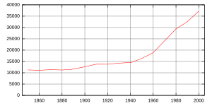
Most people in the district, about 88%, live near the big city of Basel. The district has 14 smaller towns and villages, called municipalities. It covers an area of about 112 square kilometers. As of 31 December 2020, about 48,164 people live here. This means there are about 355 people living in each square kilometer.
Contents
What is the Geography of Rheinfelden District?
The Rheinfelden District covers an area of about 112 square kilometers. A large part of this land is used for farming. About 44% of the district is farmland.
Another big part, almost 40%, is covered by forests. The rest of the land, about 13.4%, has buildings and roads. This includes homes, schools, and businesses.
Who Lives in Rheinfelden District?
As of December 2020, the Rheinfelden District has a population of 48,164 people. Many different people live here. In June 2009, about 21.3% of the people living in the district were from other countries.
How Do People Work in Rheinfelden District?
In 2000, there were 19,081 people living in the Rheinfelden District who had jobs. Most of them, about 71%, worked outside the district. This means they traveled to other areas for their jobs.
However, many people also came into the district to work. About 8,272 people traveled into Rheinfelden District for their jobs. In total, there were 13,800 jobs available in the district. These jobs were for at least 6 hours per week.
What Religions are Practiced in Rheinfelden District?
Based on information from the year 2000, many people in the Rheinfelden District belong to different Christian churches.
- About 40.2% of the people were Roman Catholic.
- About 29.9% belonged to the Swiss Reformed Church.
- Another 2,474 people were part of the Christian Catholic faith.
What About Education in Rheinfelden District?
The Rheinfelden District has schools for children and young adults. In the 2008/2009 school year:
- 3,090 students were attending primary school. These are younger children.
- 1,111 students were attending secondary school. These are older students, like those in middle and high school.
- 734 students were studying at a university or college level.
- 32 students were looking for a job after finishing school.
Which Towns are in Rheinfelden District?
The Rheinfelden District is made up of 14 different towns and villages, called municipalities. Each one has its own unique character. Here is a list of these municipalities, along with their population and area:
| Coat of arms | Municipality | Population (31 December 2020) |
Area, km2 |
|---|---|---|---|
| Hellikon | 780 | 7.05 | |
| Kaiseraugst | 5,550 | 4.91 | |
| Magden | 3,872 | 11.01 | |
| Möhlin | 11,088 | 18.79 | |
| Mumpf | 1,543 | 3.1 | |
| Obermumpf | 1,048 | 5.03 | |
| Olsberg | 356 | 4.62 | |
| Rheinfelden | 13,551 | 16.03 | |
| Schupfart | 803 | 7.04 | |
| Stein | 3,253 | 2.81 | |
| Wallbach | 1,999 | 4.51 | |
| Wegenstetten | 1,040 | 7.13 | |
| Zeiningen | 2,400 | 11.37 | |
| Zuzgen | 881 | 8.39 |
See also
 In Spanish: Distrito de Rheinfelden para niños
 | Georgia Louise Harris Brown |
 | Julian Abele |
 | Norma Merrick Sklarek |
 | William Sidney Pittman |


