
Hellikon facts for kids
Quick facts for kids
Hellikon
|
||
|---|---|---|
 |
||
|
||

Hellikon
Location in Switzerland

Hellikon
Location in Canton of Aargau
|
||
| Country | Switzerland | |
| Canton | Aargau | |
| District | Rheinfelden | |
| Area | ||
| • Total | 7.04 km2 (2.72 sq mi) | |
| Elevation | 423 m (1,388 ft) | |
| Population
(Dec 2020 )
|
||
| • Total | 780 | |
| • Density | 110.8/km2 (287.0/sq mi) | |
| Postal code |
4316
|
|
| Localities | Unterdorf, Oberdorf | |
| Surrounded by | Hemiken (BL), Buus (BL), Zuzgen, Obermumpf, Schupfahrt, Weggenstetten | |
| Twin towns | N/A | |

Hellikon is a small town, also called a municipality, in the Aargau region of Switzerland. It's located in the western part of the Fricktal area. Hellikon is about four kilometers (2.5 miles) southwest of the German border. It also shares a border with the Basel-Landschaft region.
Contents
Exploring Hellikon's Geography
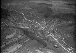
Hellikon village is in the upper part of the Möhlin valley. The Möhlinbach stream flows through this valley towards the Rhine river. The village has two main parts:
- The lower village (Unterdorf) stretches along the Möhlinbach for over a kilometer.
- The upper village (Oberdorf) is on the west side of the valley.
The valley floor near the Möhlinbach is about 200 meters (656 feet) wide. It gets wider, up to 400 meters (1,312 feet), where smaller streams join it. Hills called the Tabel Jura surround the village. These hills have steep lower parts and flat tops that are used for farming.
Land Use and Natural Features
To the east of Hellikon is the Wabrig plateau. This flat area is over a kilometer wide and stretches for more than four kilometers. A deep side valley runs west from the village. This valley separates the Neulig plateau in the north from the Egg plateau in the south.
Hellikon covers an area of about 7.05 square kilometers (2.72 square miles). A large part of this land, about 60.9%, is used for farming. Forests cover 32.6% of the area. The remaining 6.5% is used for buildings and roads.
The highest point in Hellikon is on the west side of the Neulig plateau, at 633 meters (2,077 feet) above sea level. The lowest point is at the Möhlinbach, at 397 meters (1,302 feet).
Neighboring Towns
Hellikon is surrounded by several other towns. In the Aargau region, its neighbors are Zuzgen to the northwest, Obermumpf to the northeast, Schupfart to the east, and Wegenstetten to the southeast. In the Basel-Landschaft region, Hellikon borders Buus to the west and Hemmiken to the southwest.
Hellikon's Past: A Brief History
Hellikon was first mentioned in official records in the year 1209. For a long time, the area was controlled by different powerful groups. The Habsburgs, a famous European family, were in charge of the "upper jurisdiction" (a type of legal control) in Hellikon.
Times of Change and Conflict
In 1468, the entire Fricktal region, including Hellikon, was given to the Duchy of Burgundy. However, the Burgundians lost a major war against the Old Swiss Confederacy. This meant Hellikon returned to Austrian (Habsburg) control by 1477.
The 17th century was a tough time for Hellikon. There were many wars and conflicts, like the Thirty Years' War. These events slowed down the town's growth.
Joining Switzerland
In 1797, the Fricktal region became a French protectorate, meaning it was protected and influenced by France. Later, in 1802, Rheinfelden became the capital of a new region called the Canton of Fricktal. This new canton joined the Helvetic Republic (an early Swiss state) in August of that year. Finally, on February 19, 1803, the Canton of Fricktal, including Hellikon, became part of the Aargau region of Switzerland.
A Tragic Event and New Beginnings
In 1875, a sad accident happened during the Christmas Fair. The staircase of the ten-year-old schoolhouse collapsed. Sadly, 73 people died, and most of them were children.
Between 1850 and 1950, the number of people living in Hellikon dropped by more than 20%. For a long time, farming cereals and grapes was the main way people earned money. But diseases like phylloxera (a tiny insect) destroyed the grapevines. Hellikon then changed from a farming town to a place where many people live but travel to work in bigger cities like Basel. Since the 1980s, Hellikon's population has grown by almost a third.
In August 2009, Hellikon celebrated its 800th birthday with a big village fair!
Hellikon's Flag
The flag of Hellikon shows a blue background with a green triple hill and three yellow morels (a type of mushroom). The flag was officially adopted in 1924, but people knew about it much earlier. The current design of the flag dates back to 1966.
People of Hellikon: Demographics
Hellikon has a population of about 900 people (as of 2022). A small part of the population, around 5.2%, are foreign nationals. Over the last ten years (1997–2007), the population grew by about 1%.
Languages and Age Groups
Most people in Hellikon (about 95.6%) speak German. Albanian is the second most common language, spoken by 2.4% of the people. Serbo-Croatian is third, spoken by 0.5%.
In 2008, Hellikon had a mix of age groups:
- Children (0-9 years old): 8.1%
- Teenagers (10-19 years old): 11.1%
- Young adults (20-29 years old): 13.1%
- Adults (30-59 years old): 45.7%
- Seniors (60 years and older): 22.1%
Historical Population Trends
Here's how Hellikon's population has changed over time:
| Historical population | ||
|---|---|---|
| Year | Pop. | ±% |
| 1768 | 252 | — |
| 1850 | 681 | +170.2% |
| 1870 | 705 | +3.5% |
| 1900 | 581 | −17.6% |
| 1950 | 539 | −7.2% |
| 2000 | 747 | +38.6% |
Religion in Hellikon
According to the 2000 census, about 52.1% of Hellikon's residents were Roman Catholic. Another 14.7% belonged to the Swiss Reformed Church. Interestingly, Hellikon has the highest number of people who follow the Christian Catholic faith in all of Switzerland, with about 19.8% of the population.
Hellikon's Economy
In 2007, Hellikon had a low unemployment rate of 1.65%. The town's economy is divided into three main parts:
- Primary sector: This includes farming and forestry. About 88 people work in this area.
- Secondary sector: This involves manufacturing and construction. About 47 people work here.
- Tertiary sector: This covers services like shops, offices, and transport. About 28 people work in this sector.
Many people who live in Hellikon travel to work in larger towns in the Fricktal region or in the Basel area. This means Hellikon is mostly a "commuter community."
Getting Around: Transport Links
Hellikon is located on a local road that runs through the Möhlintal valley, connecting Möhlin to Wegenstetten. A smaller road also leads to Buus. If you need to get on the main A3 motorway, the closest exits are at Rheinfelden and Eiken.
For public transport, you can use the Postauto bus service. Buses run towards Möhlin or Wegenstetten.
Places to See: Sights
The entire village of Hellikon is recognized as an important Swiss heritage site. This means it has special historical and cultural value.
Learning in Hellikon: Education
Most adults in Hellikon (between ages 25-64) have completed either high school or gone on to higher education, like university.
Schools in Hellikon
Hellikon has one kindergarten and one primary school for younger students. Middle and secondary schools for students in the Möhlintal area are located in Möhlin. There are also other secondary schools in Wegenstetten and Zeiningen for students who don't plan to go to university. Thanks to an agreement between regions, young people from Fricktal can also attend college in Muttenz.
See also
 In Spanish: Hellikon para niños
