
Mumpf facts for kids
Quick facts for kids
Mumpf
|
||
|---|---|---|
|
||

Mumpf
Location in Switzerland

Mumpf
Location in Canton of Aargau
|
||
| Country | Switzerland | |
| Canton | Aargau | |
| District | Rheinfelden | |
| Area | ||
| • Total | 3.14 km2 (1.21 sq mi) | |
| Elevation | 287 m (942 ft) | |
| Population
(Dec 2020 )
|
||
| • Total | 1,543 | |
| • Density | 491.4/km2 (1,272.7/sq mi) | |
| Postal code |
4322
|
|
| Surrounded by | Bad Säckingen (DE-BW), Obermumpf, Stein, Wallbach, Zeiningen, Zuzgen | |

Mumpf is a small town, also called a municipality, in the Rheinfelden district. It is located in the canton of Aargau in Switzerland.
Contents
History of Mumpf
Early Settlements and Roman Times
The area around Mumpf has been home to people for a very long time. In 1991, archaeologists found a fortified village from the neolithic period (New Stone Age) on a hill called Kapf/Chapf. This village had a huge moat (a deep ditch) around it, likely protected by tall palisades (strong fences made of logs). Inside, they found wooden beams, fire pits, and many stone tools.
Many other Stone Age and Bronze Age items have been found in Mumpf. There was also an Iron Age rubbish heap at Rifeld. Underneath a building called Gasthaus Anker, parts of a Roman fort from the 4th century were discovered. A Roman soldier's grave was also found nearby. Between Mumpf and Stein, a piece of a milestone (a stone marking distance on a road) from 139 AD was found.
From Medieval Times to Modern Switzerland
Mumpf was first mentioned in official records in 1218 as Mumpher. Later, in 1278, it was called Nider-Mumpfe. It kept the name Nieder-Mumpf until 1803. The town was first part of the lands ruled by the Counts of Homburg.
Later, it came under the Habsburg rulers. They had a special book of rules called an urbarium, which explained the duties between nobles and peasants. Mumpf was part of the Säckingen district under their rule.
In 1612, people in the Rhine region, including Mumpf, protested against high taxes and poverty. This led to the Rappenkrieg, a peasant uprising that lasted from 1612 to 1614. During the Thirty Years War, Mumpf was attacked and robbed several times.
In 1803, after the Act of Mediation, the entire Fricktal region, including Mumpf, became part of the new Canton of Aargau.
St. Martin's Church
The church of St. Martin in Mumpf was first mentioned in 1441. It was rebuilt and made bigger in 1541. The part of the church where the choir sings was rebuilt in 1741. The most recent updates to the church happened in 1957. The Mumpf parish (church community) also included the nearby town of Wallbach until 1938.
Old Ways of Life and New Connections
Until the 1800s, people in Mumpf mainly earned money from fishing, timber rafting (floating logs down the river), and growing grain. Mumpf and Wallbach were important members of the Rhine association, which managed river trade.
A ferry across the Rhine river has been used since the Middle Ages and still operates today. However, most people now use bridges. There's an old bridge, a railway bridge built in 1875, and the A3 motorway bridge from the 1970s. Today, many people in Mumpf work for a chemical company in the Fricktal area or in the larger city of Basel.
Geography of Mumpf
Mumpf covers an area of about 3.1 square kilometers (1.2 square miles).
- About 27% of the land is used for farming.
- About 43% is covered by forests.
- About 22% has buildings or roads.
- About 8% is made up of rivers or lakes.
Most of the built-up area is for homes and buildings, and a good part is for roads and transportation. The forests are mostly dense woods, with some smaller groups of trees. For farming, people grow crops, use land for pastures, and have orchards or vineyards. All the water in Mumpf is in rivers and streams.
The town is located in the Rheinfelden district, between the Rhine river and the edge of the Jura Mountains. Mumpf is a linear village, meaning it stretches out along a road. It also includes a small hamlet called Oberberg and a manor house at Schönegg.
Mumpf's Coat of Arms
The blazon (description) of Mumpf's coat of arms is: Green with a wavy silver stripe, between a golden spearhead and a golden oar. This design represents the town's history and location.
Population and People
Mumpf has a population of about 1,267 people (as of December 2005). About 32% of the people living in Mumpf are from other countries. Over the past 10 years (1997–2007), the population has grown by about 30%.
Most people in Mumpf (about 87%) speak German. The next most common languages are Albanian (4.5%) and Serbo-Croatian (2.9%).
Age Groups in Mumpf
Here's a look at the different age groups in Mumpf (as of 2008):
- Children (0-9 years old): 11.8%
- Teenagers (10-19 years old): 10.7%
- Young adults (20-29 years old): 12.8%
- Adults (30-39 years old): 15.5%
- Adults (40-49 years old): 19.2%
- Adults (50-59 years old): 13.1%
- Seniors (60-69 years old): 9.2%
- Seniors (70-79 years old): 5.7%
- Seniors (80-89 years old): 1.9%
- Seniors (90 and older): 0.1%
Homes and Households
In 2000, about 58% of the homes in Mumpf were owned by the people living in them. This means they didn't pay rent, though they might have a mortgage (a loan to buy the house).
In 2008, there were 232 single-family homes in Mumpf, which was about 42% of all homes and apartments.
Voting and Elections
In the 2007 Swiss federal election, the most popular political party in Mumpf was the SVP, which received 35.21% of the votes. Other popular parties included the SP (17.4%), the CVP (15.92%), and the FDP (15.66%). About 32.5% of eligible voters participated in this election.
Population Changes Over Time
Here's how Mumpf's population has changed over the years:
| Historical population | ||
|---|---|---|
| Year | Pop. | ±% |
| 1768 | 319 | — |
| 1850 | 448 | +40.4% |
| 1900 | 492 | +9.8% |
| 1950 | 598 | +21.5% |
| 1990 | 795 | +32.9% |
| 2000 | 1,084 | +36.4% |
Important Heritage Sites
Two places in Mumpf are listed as important heritage sites in Switzerland:
- The prehistoric settlement called Chapf.
- The Gasthaus Anker, which was built on the site of an old Roman fort by the Rhine river.
Economy and Jobs
In 2007, the unemployment rate in Mumpf was 2.83%. This means a small percentage of people looking for jobs couldn't find them.
Types of Jobs
- Primary Sector: In 2005, 16 people worked in farming and related businesses. There were about 6 businesses in this sector.
- Secondary Sector: 43 people worked in manufacturing and industry. There were 12 businesses in this sector.
- Tertiary Sector: 75 people worked in services (like shops, hotels, and offices). There were 28 businesses in this sector.
In 2000, 569 people who lived in Mumpf had jobs. Most of them (about 82%) worked outside of Mumpf. However, 72 people came into Mumpf for work. There were 172 jobs available in the town. About 19% of working people used public transportation to get to work, and 53.6% used a private car.
Religion in Mumpf
Based on the 2000 census:
- About 49.4% of the population were Roman Catholic.
- About 22.9% belonged to the Swiss Reformed Church (Protestant).
- About 1.66% belonged to the Christian Catholic Church of Switzerland.
Transportation
Mumpf is located on the Bözberg railway line. It has its own train station, Mumpf, where local trains stop.
Education in Mumpf
In Mumpf, about 65% of adults (aged 25-64) have completed either non-mandatory upper secondary education (like high school) or higher education (like university or a specialized college).
In the 2008/2009 school year:
- 101 students attended primary school in Mumpf.
- 151 students attended secondary school in the municipality.
Images for kids
-
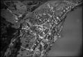
Aerial view of Mumpf in 1949.
-
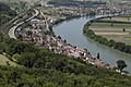
A view of the Mumpferflue, a rock formation near Mumpf.

See also
 In Spanish: Mumpf para niños
