
Rimouski River facts for kids
Quick facts for kids Rimouski River |
|
|---|---|

Price sawmill on Rimouski River in 1914
|
|
| Country | Canada |
| City | Rimouski |
| Physical characteristics | |
| Main source | Saint-Quentin Parish, New Brunswick, Restigouche County, New Brunswick 460 m (1,510 ft) 47°53′37″N 68°20′08″W / 47.89361°N 68.33556°W |
| River mouth | Rimouski, MRC of Rimouski-Neigette, Quebec 0 m (0 ft) 48°28′14″N 68°31′17″W / 48.47056°N 68.52139°W |
| Length | 119.2 km (74.1 mi) |
| Basin features | |
| Basin size | 1,635 km2 (631 sq mi) |
| Tributaries |
|
The Rimouski River is a river in Quebec, Canada. It flows into the St. Lawrence River at the city of Rimouski. This city is located on the south shore of the St. Lawrence.
The river starts in New Brunswick and then flows through Quebec. It passes through several areas, including Lac-Huron, Quebec, La Trinité-des-Monts, Saint-Narcisse-de-Rimouski, Saint-Valérien, and finally the city of Rimouski.
Contents
Where is the Rimouski River?
The River's Journey: From Source to Sea
The Rimouski River begins its journey high up in the Notre Dame Mountains. Its source is Miller Lake, which is about 460 metres (1,510 ft) above sea level. This lake is found in Saint-Quentin Parish, New Brunswick.
The river flows for about 119.2 kilometres (74.1 mi) in total. It starts in New Brunswick and quickly crosses into Quebec.
Upper River: From Miller Lake to Rimouski Lake
In its upper part, the river flows through forests and collects water from smaller streams. It passes by Lake Santerre. The river also flows into and out of Rimouski Lake. This lake is about 320 metres (1,050 ft) high. There is a dam at the northwest end of Rimouski Lake.
Middle River: Through Wildlife Reserves
After Rimouski Lake, the river enters the Rimouski Wildlife Reserve. Here, it picks up water from White Creek and the outlet of Beaver Lake. It also meets the East Rimouski River.
The river then flows west, passing "Roches Labbé" and the "Three Little Saults" dam. It goes through rapids called "rapides à Poirier". This part of the river is known for its beautiful natural scenery.
Lower River: Towards the St. Lawrence
Further downstream, the Rimouski River flows through the Duchenier Wildlife Sanctuary. It passes several waterfalls and rapids. It also meets the Grand Touradi River and the France River.
As it gets closer to the sea, the river flows past the "Canyon of Hell’s Gates". It collects water from the Little Touradi River, the White River (Rimouski River), and the Black river (Rimouski River).
Finally, the Rimouski River flows through the city of Rimouski. It goes under Highway 20 and a railway bridge. The river then empties into the St. Lawrence River. At low tide, the river's mouth can stretch up to 3.0 kilometres (1.9 mi) into the St. Lawrence. This area forms the harbor of Rimouski, facing Saint-Barnabé Island.
How Much Water Does the River Carry?
The area that drains into the Rimouski River is called its watershed. This watershed covers about 1,635 square kilometres (631 sq mi). Most of this area (98.6%) is in Quebec.
The river's average flow (called its "module") is about 30 metres (98 ft) per second. The highest flow ever recorded was 530 cubic metres per second (19,000 cu ft/s), and the lowest was 1.6 cubic metres per second (57 cu ft/s). The river usually has high water levels in early May and a smaller rise in late October.
The Rimouski River receives water from 29 smaller streams. The main ones are the East Rimouski River, the Grand Touradi River, the Little Touradi River, and the Little Rimouski River. The entire network of streams in the basin is about 2,090 kilometres (1,300 mi) long. There are also 864 lakes and 244 wetlands in the river basin.
What is the Land Like Around the River?
The entire area around the Rimouski River is part of the Appalachian Mountains. The rocks in this region are sedimentary rocks. These rocks formed between 505 and 360 million years ago. They are lined up in rows that run parallel to the St. Lawrence River.
Where Does the Name "Rimouski" Come From?
The name "Rimouski" first appeared in a document about the Lordship of Rimouski on April 24, 1968.
Some people believe the name comes from the Mi'kmaq word animouski, which means "mansion of dog". Another idea is that it comes from the Abenaki word Alemoski, meaning "earth of the dog". Some think it refers to the presence of seals, which are sometimes called "sea dogs," near the river's mouth.
People Living Near the River
In 2007, about 50,306 people lived in the Rimouski River basin. Most of them (85%) live in the city of Rimouski, which is the only large city in the area.
Plants and Animals of the Rimouski River
Forests and Trees
The forests in the Rimouski River basin are made up of different types of trees. In public forests, almost half (47.2%) are conifers (like pine and spruce trees). About 23.5% are mixed forests, which have both conifers and deciduous trees (trees that lose their leaves). In private forests, mixed forests are common, and 23.5% are deciduous forests. Most of the forests are quite young, with only about 2.6% being older than 120 years. About 1% of the forests are cut down each year.
Fish and Other Water Animals
The Rimouski River is home to 31 different kinds of fish. Some common fish found here include the brook trout, the chub, the northern pearl dace, and the red shiner belly. The mouth of the river is a popular spot for rainbow smelt.
The Atlantic salmon is also found in the river. These salmon travel about 29 kilometres (18 mi) upstream from the mouth to lay their eggs.
Besides fish, four types of mammal live in the river: the Canadian beaver, the muskrat, the river otter, and the American mink. The area also has 132 kinds of birds, 15 kinds of amphibians (like frogs and salamanders), and six kinds of reptiles (like snakes and turtles).
Protecting the Land and Wildlife
The Rimouski River basin has several areas set aside to protect nature. These include two wildlife reserves: the Rimouski Wildlife Reserve and the Duchénier Wildlife Sanctuary. There are also two controlled harvesting zones (ZECs) where hunting and fishing are managed.
Other protected areas include three places where deer gather, covering 13.9% of the land. There are also two heronries (places where herons nest), five muskrat habitats, and four special exceptional forest ecosystems.
A Look at the River's Past
The history of the Rimouski River basin is closely linked to logging. The Price Brothers and Company had a very strong hold on this activity for a long time.
A big event in the area's history was the Rimouski fire on May 6, 1950. A sawmill fire spread and burned down 250 houses. This left more than 2,000 people without homes.
Images for kids
-
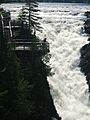
"Le Grand Sault" (The Grand Canyon) at Sault de Hell Gates

