River Ant facts for kids
Quick facts for kids Ant |
|
|---|---|

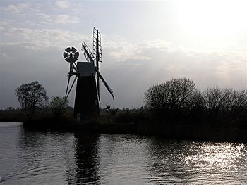
The river at How Hill
|
|
|
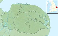
Location of the river mouth within Norfolk
|
|
| Country | England |
| Region | Norfolk |
| Physical characteristics | |
| Main source | Antingham 27 m (89 ft) 52°51′03″N 1°21′12″E / 52.8507°N 1.3533°E |
| River mouth | River Bure Ant Mouth, south of Ludham Bridge 0 m (0 ft) 52°41′23″N 1°30′47″E / 52.6896°N 1.5131°E |
| Length | 27.3 km (17.0 mi) |
| Basin features | |
| River system | River Bure |
The River Ant is a cool river in Norfolk, England. It flows into a bigger river called the River Bure. The River Ant is about 27 kilometers (17 miles) long. It drops 27 meters (89 feet) from where it starts to where it ends. Some people say the river used to be called the River Smale. This might be how the village of Smallburgh got its name! The area around the river, called the Ant Broads & Marshes NNR, is a special nature reserve.
Contents
Where the River Ant Begins
The River Ant starts near the village of Antingham in North Norfolk. It begins at Antingham Ponds. Just below these ponds, the river's path was once used as a canal. This canal started at a place called Antingham bone mill.
The North Walsham & Dilham Canal
In 1812, a special law was passed to build the North Walsham & Dilham Canal. This canal was made wide enough for a type of boat called a Norfolk wherry. It cost a lot of money, about £30,000, and opened on July 25, 1826. This canal made the river easy to travel on all the way to Dilham.
Boats on the canal carried things like manure, flour, coal, and farm goods. In 1885, the canal was sold for £600. Sadly, the lawyer who handled the sale disappeared with the money! A big flood in 1912 washed away some of the boat docks. The last trading trip on the canal was made by a wherry named "Ella" in 1934. The canal is still owned by the North Walsham Canal Company today.
The river, now in its canal form, goes around the northeast side of North Walsham. It passes Bacton Wood Mill. Below Bacton Mill, the canal reaches a lock at Ebridge Mill. A lock is like a water elevator for boats. This lock is old, but people hope to fix this part of the canal so boats can use it again. Further along, at Briggate Bridge, there is another mill and another old, unused lock.
Exploring the Norfolk Broads
At Honing Bridge, the river enters The Broads. This area is managed by The Broads Authority. Here, the canal goes through a marshy, wooded area called Dilham Broad. It then turns east before heading south again. It passes under Tonnage Bridge.
Below Tonnage Bridge, the river flows through Broad Fen. This area has many small water channels. It also meets Tyler's Cut, which goes west. Tyler's Cut used to serve the villages of Dilham and Smallburgh. It was the furthest north boats could go on the River Ant before the North Walsham and Dilham Canal was built.
Wayford Bridge and Ancient Discoveries
At Wayford Bridge, you can see the Wayford Bridge Hotel and small houses on floating platforms. The bridge itself is a modern concrete bridge that carries the A149 road. It has about 7 feet (2.1 meters) of space underneath, so only small boats can pass.
In 1976, when workers were digging for a new road, they found parts of what might have been a Roman boat! It was found in the mud near the bridge. They also found part of a wooden walkway. This walkway probably led to a shallow crossing that was there before the first bridge was built in 1797.
Even older discoveries were made here! In 1927, during river cleaning, a wooden dug-out canoe was found. It was later found to be from the year 720, making it the oldest boat ever found in Norfolk! A Roman road used to run from the west side of the bridge.
Mills and Waterways
As you continue downstream, you'll see boatyards on both sides of the river. The river passes the old ruins of Moy's Drainage Mill. This mill used to pump water from the land into the river. It worked until after 1935. By 2007, only a small part of the tower was left.
The river then goes to the very pretty Hunsett Drainage Mill. This building is from 1860. It used to power two scoop wheels to lift water into the river. It was fixed up on the outside in 1945. The river then turns south and passes a channel that leads east to the boat docks at Stalham and Sutton.
Stalham Dyke turns northeast to reach many boat docks. Sutton Dyke continues east to its dock, passing through Sutton Broad. This broad is no longer open water because the boat channel is surrounded by tall reeds. The riverbanks of Barton Fen are full of trees, marshes, and reeds. These reeds were harvested for hundreds of years to make thatched roofs.
Barton Broad: A Special Place
As the river gets close to Barton Broad, it passes a triangular island called The Heater. The channels on either side lead to Barton Turf boat dock and its boatyard. The river then enters Barton Broad. This is the second largest of The Broads, only smaller than Hickling Broad. It covers about 170 acres (0.69 square kilometers).
Since 1995, a lot of work has been done to make more open water and clean up the muddy bottom of the broad. The Broads Authority even used "curtains of bubbles" to stop fish from entering the broad. This allowed tiny water fleas to grow, which helped clear the cloudy water. Barton Broad is a Site of Special Scientific Interest (SSSI) and a nature reserve managed by the Norfolk Wildlife Trust.
Barton Broad is special because it has an island called "Pleasure Hill." It's believed that Lord Nelson learned to sail on Barton Broad when he was 12 years old, before he joined the navy. His sister owned the broad at that time. There are several boat docks connected to the broad by channels. These include Catfield Wood End dock to the east and Old Lime Kiln Dyke, which ends at a dock in Neatishead to the west. Britain's first solar-powered passenger boat, called Ra, operates from Neatishead dock.
Lower River and Historic Mills
The Ant leaves Barton Broad from its southeast corner. This spot is officially where the river starts to be affected by tides. It enters a part called "The Shoals" to the east of Irstead. This village has some beautiful cottages with thatched roofs. The church of St Michael is a grade II* listed building. Much of it was built in the 14th and 15th centuries.
As the river winds through the flat Broadland countryside, you'll see several drainage mills along its banks.
- The first is Clayrack Drainage Mill, near the entrance to Crome's Broad. This mill was moved here in 1981 to save it. It's one of only three hollow post windpumps in Norfolk.
- A little further downstream, on the east bank, is Boardman's Windmill. It was built in the late 1800s. It stopped working in 1938 after a storm.
- Turf Fen drainage mill is on the west bank. It was built around 1875 to drain the Horning marshes. It stopped working in 1944.
Next, the river passes How Hill nature reserve, which you can visit. There are nature trails that go through marshy areas and woodlands. You can walk or take an electric boat. The site includes Toad Hole Cottage, a small house that shows what life was like in the 1880s. You can also walk through the gardens and find a tea room. How Hill House is an educational center and not open to the public.
Below How Hill, the river makes a wide bend. It passes Neaves Drainage Mill as it heads towards Ludham Bridge. This mill was built in 1870. Ludham Bridge drainage mill was built around 1877. During World War II, it was used as a lookout spot by the home guard. Only the brick tower remains, and it leans to one side!
Ludham Bridge carries the A1062 road over the Ant. The river then turns sharply east before straightening out. It then turns south and joins the River Bure at Ant Mouth. To the east of where the rivers meet are the remains of St James's Hospital. To the west are the ruins of St Benet’s Abbey. This abbey was founded in 1019 by Benedictine monks.
River Boats and History
In August 2010, workers found the remains of a Saxon boat while doing flood defense work on the river. The boat was about 3 meters (9.8 feet) long. It was carved out of a single piece of oak wood. It was found at the bottom of the river between Honing Hall and Brown's Hill. Five animal skulls were found near the boat. The boat was sent to experts in York to be preserved. Once it's ready, it will be displayed at the Castle Museum in Norwich for everyone to see.
A special type of Norfolk wherry boat was used on the River Ant. These boats could be up to 50 feet (15 meters) long and 12 feet (3.7 meters) wide.
River Water Quality
The Environment Agency checks the water quality of rivers in England. They give each river system an overall "ecological status." This status can be high, good, moderate, poor, or bad. They look at things like the types of invertebrates (bugs), plants, and fish in the water. They also check the "chemical status," which compares how much of certain chemicals are in the water to safe levels. Chemical status is rated as good or fail.
In 2016, the water quality of the River Ant system was mostly "moderate." This means it's not perfect, but it's not bad either. The main reasons for this are changes made to the river channel. For the North Walsham and Dilham Canal part, it's also because a lot of water is taken out for farming. Some parts of the river have improved, as they were rated "Bad" from 2013 to 2015.
 | Aurelia Browder |
 | Nannie Helen Burroughs |
 | Michelle Alexander |


