River Ash, Surrey facts for kids
Quick facts for kids River Ash |
|
|---|---|

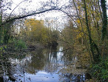
Reach with wider banks, reeds and woodland close to Shepperton Studios
|
|

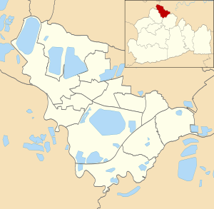
The southernmost inner west-east line marks the end of the river, the rest is wholly in the same Borough shown.
|
|
| Country/Nation | United Kingdom |
| Region/Country | England |
| County | Surrey |
| City | Sunbury-on-Thames, Shepperton, Littleton , Laleham, Ashford, Staines-upon-Thames |
| Physical characteristics | |
| Main source | Sluice against lower River Colne Staines-upon-Thames, Spelthorne, England, United Kingdom 14 m (46 ft) |
| River mouth | River Thames Sunbury-on-Thames and Shepperton, Spelthorne, England, United Kingdom 8.6 m (28 ft) |
| Length | 10 km (6.2 mi) |
| Width |
|
| Depth |
|
| Basin features | |
| Progression | Colne—Ash—Thames |
| Artificial extra source: outflow of un-useable water from fresh waterworks | |
The River Ash is a small river in Surrey, England. It's about 10 kilometers (6 miles) long. It flows just outside Greater London. Over time, people have changed parts of the river. They have made it straighter, cleared it, and created two special areas called backwaters. One backwater is very old, from the Middle Ages. The other was made in the 1990s.
The River Ash is one of six smaller rivers that branch off the River Colne. It starts south of Staines Moor and flows east through the area of borough of Spelthorne. Finally, it joins the famous River Thames. You can't use boats on the River Ash. However, it's full of plants and insects. You'll find many reeds, different types of sedges (like bulrushes), and pond-skaters. It's also home to amphibians, moths, and butterflies. The river helps make the Ash Link Nature Reserve and other local parks special places for nature. It's known as a very important natural feature in its area.
Contents
River Ash Journey
The River Ash is a branch of the River Colne. It forms a natural border for parts of Staines-upon-Thames, first with Stanwell and then with Ashford. The river then turns south. It divides Littleton (where the Queen Mary Reservoir and a nature reserve are) from Laleham. After that, it flows east again.
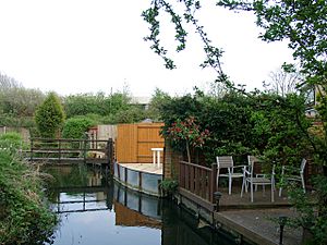
The river marks the northern edge of a small area called Shepperton Green. Further along, the Sunbury Golf Course is on one side of the river. This golf course was built on an old landfill site. Then, a farm in the Metropolitan Green Belt crosses the river. The River Ash eventually flows gently into the Creek, which is a side stream of the River Thames. It faces a long island called Wheatley's Ait. The river runs behind many gardens, and some even have small footbridges over it. The main towns in the area are far enough away, which helps keep the river clean and full of wildlife. You can enjoy walks along the river in parks like Fordbridge Park in Ashford. People usually don't canoe on the river because it has small dams, very narrow spots, and underground tunnels.
How the River Ash Flows
The River Ash is a medium-sized river when compared to other branches of the Colne.
- It has more water than:
- Sweeps Ditch, Staines (which might not be a branch of the Colne anymore)
- The long but decorative Duke of Northumberland's River
- The Longford River
- It usually has less water than:
- The short main Colne channel
- The Colne Brook
- The River Wraysbury (which joins the Colne very close to the Thames)
River Ash Water Quality
The River Ash usually has very clean water. This is because the water treatment plants along the Colne valley have improved a lot. For a river that doesn't flow very fast, it has low levels of eutrophication (too many nutrients) and sediment build-up. The river is considered a key natural feature in its local area.
The Environment Agency checks the water quality of rivers in England. They give each river an overall "ecological status." This status can be high, good, moderate, poor, or bad. They look at things like the types and numbers of invertebrates (bugs), plants, and fish. They also check the "chemical status," which compares chemical levels to safe limits. Chemical status is either good or fail.
Here's how the River Ash's water quality was in 2019:
| Section | Ecological Status |
Chemical Status |
Overall Status |
Length | Catchment | Channel |
|---|---|---|---|---|---|---|
| Surrey Ash | Moderate | Fail | Moderate | 11.127 km (6.914 mi) | 19.015 km2 (7.342 sq mi) |
River Ash History
The town of Ashford gets its name from the River Ash. The river formed the southern border for most of the town for a long time. Old maps from the Middle Ages show how the river's path has changed, sometimes by people. One very old map shows different channels near Shepperton Studios. This map was made for the Lord of Shepperton Manor. It mentions that monks from Westminster made parts of the river wider to create fish ponds.
Since 1910, the Staines Aqueduct (a water channel) looks like the western part of the River Ash. It carries water from the River Thames further west to water treatment plants. To cross this aqueduct and other areas, the river flows underground in a culvert near Birch Green, Shortwood Allotments, and the Queen Mary Reservoir.
The middle part of the river was moved a little west to make space for the Queen Mary Reservoir in Littleton. You can still see a small hint of the original river path near the reservoir's pumping station. In the early 1960s, the river's starting point from the Colne was moved south. Further east, 100 meters of the river were moved to make way for the Staines Bypass (the A30). It then flows underground for 270 meters beneath a large roundabout called Crooked Billet.
Flooding in 1947 and 2014
Some streets in north-eastern Staines-upon-Thames experienced flooding in February 2014. At least 80 homes reported water inside, in outbuildings, or in their yards. The flooding was complicated by an aqueduct that overflowed and several sluices (water gates). One sluice was too small, and another was not operated correctly. A similar flood happened in 1947, when many areas in the Thames Valley were flooded.
Protecting Against Floods
In 1994-1995, improvements were made to the water treatment works at Ashford Common by Thames Water. This caused more water to flow steadily east of the M3. This increased the risk of flooding for homes in Shepperton. So, public money was used for the River Ash Flood Alleviation Scheme. Now, there are deep holding areas before the water from the treatment works is released. Also, in Sunbury Golf Course, a special relief channel was built in 1995 to help manage floodwaters. This project cost £450,000.
Squires Bridge
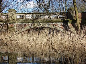
Squires Bridge is a long bridge with two arches. It's made of carefully cut stone and has seven stone railings on each side of each arch. This bridge is a protected historic building (Grade II). It was built around 1870. The Wood family, who owned the Manor House at what is now Shepperton Studios, helped pay for it. The bridge has a coat of arms with three swords, which is the symbol for Middlesex, not the Wood family.
Nature and Wildlife Along the River Ash
Ash Link Local Nature Reserve is the first nature reserve in Spelthorne. It was opened in June 2012. Volunteers from the Spelthorne Natural History Society help manage it with the local council. It's in Shepperton, on both sides of the M3. The southern part is called Splash Meadow, and the northern part is Nutty Wood.
The Reserve has a large footbridge connecting its parts. It's home to many types of wildlife, mixed woodlands, wildflower areas, ponds, and the river itself. Over the years, conservation efforts have helped increase the number of different plants and animals here. Volunteers keep track of the species and work to make the area even better for wildlife and for people to enjoy. In 2017, Ash Link Local Nature Reserve won a Gold Medal in a competition by the Royal Horticultural Society. The next year, the volunteers received the 'Queen's Award for Voluntary Services.'
Near Shepperton Studios, there's a strip of land called Studios Walk that runs along the Ash. It has a paved path for easy walking and good spots to view the river. There are also unpaved paths. The woodland here is very important for nature. It has many old oak trees (quercus robur). These old oaks support a huge number of insects. An oak tree can have 100 times more insects than a sycamore tree (acer pseudoplatanus). These insects then provide food for bats, mice, and squirrels. The rough bark and natural cracks in old trees are perfect places for animals to rest. As trees get older and parts die, they create dead wood. This dead wood is a great home for stag beetles (lucanidae), which are special insects that need large pieces of dead wood for their food and for their young to grow.
You can often see Kingfishers (alcedo atthis) in these areas. They use the river to find food. The plants along the river banks and in the water, along with the calm sections of the river, are also perfect hiding spots for amphibians. In 2016, a project was done with the Environment Agency. It was part of a program to improve fish movement. They changed a small dam, put in a new control structure, and brought back an old river channel to act as a bypass. The main goal was to make it easier for fish to move along the river. About 600 meters of the river were improved to create better water flow and better habitats for many different species.
 | Delilah Pierce |
 | Gordon Parks |
 | Augusta Savage |
 | Charles Ethan Porter |


