
Ashford, Surrey facts for kids
Quick facts for kids Ashford |
|
|---|---|
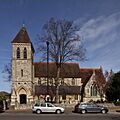
 St Matthew's C of E parish church. |
|
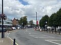
 Church Road, Ashford's high street. The town clock installed in 2011 is on the right. |
|

Ashford
|
|
| Area | 6.71 km2 (2.59 sq mi) |
| Population | 27,382 (2011 census) |
| • Density | 4,081/km2 (10,570/sq mi) |
| OS grid reference | TQ065715 |
| Civil parish |
|
| District |
|
| Shire county | |
| Region | |
| Country | England |
| Sovereign state | United Kingdom |
| Post town | ASHFORD |
| Postcode district | TW15 |
| Dialling code | 01784 |
| Police | Surrey |
| Fire | Surrey |
| Ambulance | South East Coast |
| EU Parliament | South East England |
| UK Parliament |
|
Ashford is a town in Spelthorne, Surrey, England. It is about 14 miles (22.5 km) west of central London. The town's name comes from a place where people could cross the River Ash. This river is a small branch of the River Colne.
Ashford used to be part of Middlesex until 1965, when it became part of Surrey. The town mainly has smaller buildings and houses, not tall skyscrapers. Many homes are semi-detached, meaning they are joined to another house. In 2011, about 27,382 people lived in Ashford.
Ashford railway station connects the town to other places. It is on the Waterloo to Reading Line and is served by South Western Railway trains. Heathrow Airport is also very close, about 2.5 miles (4 km) north of the town.
Ashford is home to a top gymnastics club and one of the campuses of Brooklands College. Ashford Hospital is located north of the town centre. The area called Ashford Common has shops and homes. It also includes part of the Queen Mary Reservoir and its water treatment works. The town is surrounded by green spaces like The Princes Club, Bedfont Lakes, and Shortwood Common.
Contents
What is the Land Like in Ashford?

Ashford is located on a mostly flat plain. This area was formed by old paths of the River Thames. The soil here is quite fertile but has a lot of gravel. Long ago, this land was covered by forests, with open meadows for pasture (where animals graze) and some farming. Even today, sheep graze around the large reservoirs.
In the 20th century, people dug up a lot of the gravel close to the surface. This digging created the lakes you can see north of the railway line. The far west of Ashford includes Shortwood Common, which has a recreation ground, a school, and a cemetery.
North of Ashford are the Staines Reservoirs. Other green areas like The Princes Club and Bedfont Lakes act as special protected green areas for the country's largest city. A big part of the Queen Mary Reservoir is also nearby. This reservoir is named after Mary of Teck, the wife of King George V.
Most of Ashford is covered by suburban homes and low-rise buildings. There are also many recreational areas. Some meadows are used for walking, horse riding, and other activities. Parks like Ashford Reservoirs and Spelthorne Park are reminders that this area used to be a large shared grazing land for animals. These parks also include sports clubs like Spelthorne Sports Club.
A Look at Ashford's Past
Bronze Age tools and objects have been found in Ashford. This is why a prison here is named Bronzefield. It's possible a henge (a type of ancient monument) was also here long ago.
Ashford is mentioned in the Domesday Book (a very old survey of England) as Exeforde. A stone bridge was built over the ford (crossing point) in 1789.
Ashford Common was a large area of shared land. The British Army used it for military displays during the time of King George III. This common land was divided up in 1809.
Ashford Manor Golf Club started in 1902. The large manor estate and house that once belonged to Solomon Abraham Hart were divided up before 1902. The title of Lord of the Manor was later bought by Scott Freeman in 1890. More recently, Russell Grant, a famous astrologer, acquired this title.
Most of the houses in Ashford are a mix of detached (stand-alone) and semi-detached homes. They were built between 1885 and 1960.
Former Schools in Ashford

The Welsh School (later called St David's School) opened in 1857. Its building, north of Ashford railway station, is in the Gothic Revival style. Today, St David's School no longer exists. In 2010, its buildings became the home of St James Senior Boys School.

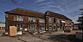
Ashford County Grammar School was founded in 1911. It later became Ashford Sixth Form College in 1975, and then Spelthorne College. In 2007, it joined with Brooklands College. The old grammar school buildings were later bought by a property developer. In 2017, the developer started to pull down the buildings. They later received permission to build 357 new homes on the site.
How Ashford is Governed
In 1894, Ashford became part of the Staines Rural District in Middlesex. In 1930, it joined the Staines Urban District. In 1965, the urban district was moved to Surrey. Then, in 1974, the Staines Urban District joined with another area to create the current borough of Spelthorne.
Churches in Ashford

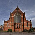
The main Church of England parish church in Ashford is St Matthew's on Church Road. It was built between 1856 and 1858. It replaced an older church called St Michael's, which had parts from the Norman period. Some old parts and monuments from St Michael's were moved into the new St Matthew's church. The famous architect William Butterfield designed St Matthew's in a Gothic Revival style. Its tower was finished in 1865.
St Hilda's parish church was built to serve the growing community near the railway station. Construction started in 1912. The church was mostly built in the first few years, but some parts were not finished until 1928. St Hilda's was originally planned to have a tall spire, but it was never built.

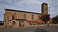
The Roman Catholic Church of St Michael is on Fordbridge Road. Building started in 1927, and the church was blessed in 1928, even though it wasn't fully finished. Sir Giles Gilbert Scott designed it in a Romanesque Revival style. Construction continued in 1938, but the tower was not completed until 1960.
Ashford also has two Methodist churches and a Congregational church. The Salvation Army has a building in Woodthorpe Road.
Ashford's Economy
_War_Memorial.jpg)
Church Road is the main street in Ashford. It has many local businesses, including supermarkets like Co-op, Tesco Express, and Sainsbury's. You can also find coffee shops, estate agents, and places to eat. The Ashford Library and a important World War I memorial are also on Church Road.
There are several pubs in the town, such as the King's Fairway, the District Arms, and the Bulldog.
Ashford has very low unemployment, like most areas around London. Many people work at Heathrow Airport nearby. BP International is another big employer in the area. Many other residents travel to work in London or the Thames Valley. Car dealerships for brands like Ford and Citroën are located on the main roads outside the town.
The town used to have several banks, but they have all closed. In 2010, there was an attempted robbery at the Barclays branch on Church Road. A man with a fake gun and bomb took hostages but later surrendered to the police.
Getting Around Ashford
_station_high_eastbound.JPG)
Train Travel
Ashford (Surrey) station is on the Waterloo to Reading Line. South Western Railway trains stop here, connecting to London Waterloo and other places like Windsor & Eton Riverside and Weybridge. The station is called Ashford (Surrey) in timetables to avoid confusion with Ashford International station in Kent.
Roads
The A30 dual carriageway is not far north of the station. It forms much of Ashford's northern border. This road follows an old route from London to Devon and Cornwall.
The A308 is another main road that runs through Ashford. It is now a dual carriageway. This road marks some of the town's southern border. Ashford is also close to major motorways like the M25, M3, and A3 road.
Buses
Buses connect Ashford to many places. The Hallmark Connections route 555 goes from Heathrow Airport to Walton-on-Thames. There are also three Transport for London routes: the 117, 216, and 290. These routes serve areas like Isleworth, Kingston upon Thames, and Twickenham.
Education in Ashford
Primary Schools
- St Michael's Roman Catholic Primary School
- Ashford Church of England Primary School
- Echelford Primary School
- Spelthorne Junior School
- Ashford Park Primary School
- Ashford Infants School
- Spelthorne Infant and Nursery School
- Clarendon Primary School and Children Centre
Secondary Schools
- Thomas Knyvett College
- St James Senior Boys School, which is a private school.
There are also secondary schools in nearby Sunbury-on-Thames, including The Bishop Wand Church of England School and St Paul's Catholic College.
Further Education
Ashford's college for further education, Spelthorne College, became a Brooklands College Campus in 2007. In 2016, the Ashford Campus moved to a new building next to Thomas Knyvett College. The old Spelthorne College site was then pulled down. This college serves students aged 16 to 18 from a wide area of Surrey.
Sports in Ashford

Ashford has many active sports clubs that compete at different levels. These include Ashford Town F.C., Ashford Casuals F.C., and Ashford Cricket Club. There are also clubs for hockey, tennis, table tennis, aikido, karate, golf, and bowls. The town has leading clubs in acrobatic gymnastics and sailing, which offer coaching from Olympic-level coaches.
Ashford Manor Golf Club has an 18-hole golf course. Another golf course in the area is Sunbury Golf Course in Charlton.
Spelthorne Atoms (formerly Ashford Atoms) are one of the best youth basketball teams in the country. They have reached the national finals many times.
Spelthorne Gymnastics club is one of the world's top clubs for acrobatic gymnastics. They have won eight World championship gold medals!
Rivers and Waterways

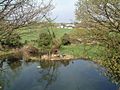
Ashford has one river, the River Ash. It is one of six branches of the River Colne. The River Ash flows under the Fordbridge roundabout. Its upper part forms the traditional border with Staines.
The Staines Reservoirs Aqueduct (built in 1902) flows from west to east across Ashford. This aqueduct carries water from the Staines Reservoirs and King George VI Reservoir to water treatment works in Hampton.
Population and Homes
Ashford has a mix of homes. In 2011, there were 11,065 households. About 29% of people owned their homes completely, and 33.9% owned their homes with a loan. The rest of the homes were rented.
Famous People from Ashford

- Sarah Ayton, Olympic gold medallist in sailing (2004 and 2008)
- Anthony Burgess, a famous novelist
- Bobby Davro, a TV impressionist and actor
- Ray Dorset, singer-songwriter from the band Mungo Jerry
- Russell Grant, an astrologer and actor
- Roger Johnson, a footballer
- Toby Roland-Jones, an England cricketer
- Greg Searle, Olympic gold medallist in rowing (1992)
- Spelbound, an acrobatic group who won Britain's Got Talent in 2010
- Anthony Watson, an England rugby union player
- Sarah Webb, Olympic gold medallist in sailing (2004 and 2008)
- Norman Willis, a former leader of the Trades Union Congress (TUC)
- Ruth Wilson, an actress who has won a Golden Globe and two Laurence Olivier Awards
- Phil Younghusband, a footballer and top scorer for the Philippines national football team
Images for kids
-
St Matthew's Church of England parish church.
-
Church Road, Ashford's high street. The town clock installed in 2011 is on the right.
-
Part of Ashford Park.
-
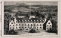
The Welsh School when it was new in 1857.
-
The former Ashford County Grammar School.
-
St Hilda's Church of England parish church.
-
St Michael's Roman Catholic church.
-
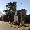
The War memorial on Church Road, with St Michael's church in the background.
-
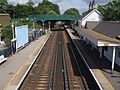
Ashford railway station.
-
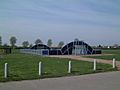
Ashford Park – part of fields and a football court.
-
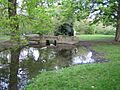
The River Ash in Fordbridge Park.
-
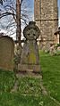
The grave of James Hawksford (1832–1904) in St Matthew's churchyard.
See also
 In Spanish: Ashford (Surrey) para niños
