Stanwell facts for kids
Quick facts for kids Stanwell |
|
|---|---|
 Parish Church of St Mary the Virgin |
|
| Area | 5.13 km2 (1.98 sq mi) |
| Population | 11,279 (2011 census) |
| • Density | 2,199/km2 (5,700/sq mi) |
| OS grid reference | TQ055735 |
| District |
|
| Shire county | |
| Region | |
| Country | England |
| Sovereign state | United Kingdom |
| Post town | Staines-upon-Thames |
| Postcode district | TW19 |
| Dialling code | 01784 |
| Police | Surrey |
| Fire | Surrey |
| Ambulance | South East Coast |
| EU Parliament | South East England |
| UK Parliament |
|
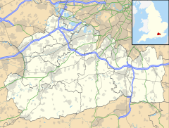
Stanwell is a village located in the Spelthorne area of Surrey, England. It is about 16 miles (26 km) west of central London. A small part of its land is used for businesses linked to nearby Heathrow Airport. The rest of the village is mostly homes and places for fun activities. Stanwell used to be part of Middlesex county, but since 1965, it has been in Surrey. The village is south of Heathrow Airport's cargo area and east of the Staines Reservoirs. Stanwell is the most northern town in Surrey, right next to Berkshire and Greater London.
Over the years, Stanwell's size has changed a lot, especially in the 20th century. Land was used for reservoirs around 1900. Later, more land was taken for Heathrow Airport. In 1995, after the M25 motorway was finished, the nearby area of Poyle became part of Colnbrook in the Borough of Slough.
Stanwell Moor is close to the village and has many reservoirs around it. It was known as a manor (a large estate) in medieval times. It has fields for horses, plant nurseries, and flood meadows. Stanwell Moor is about 1 mile (1.6 km) from the old center of Stanwell. It is part of the same local government area and church parish.
Contents
History of Stanwell
There are two ideas about where the name Stanwell comes from. One idea is that it was named after St Ann(e)'s well in the village. However, church records show the local church has always been dedicated to St Mary. The second idea is that it means 'stone well', referring to stony ground or a nearby street. The first part of the name is similar to nearby Staines-upon-Thames, which also means 'stones'.
Early History and Domesday Book
The Domesday Book of 1086 recorded 'Stanwelle' as being owned by Walter, son of Othere. This shows it was one of the important estates kept by people with Anglo-Saxon names. The Domesday Book listed its assets as: 15 hides (an old land measure), 4 mills, 3 weirs, 10 ploughs, meadow land, and woodland. It made £14 a year for its owners. The River Colne, which was full of fish, formed the western border of the village and of Middlesex.
Stanwell and Thomas Knyvet
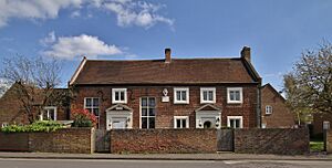
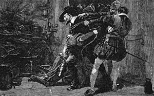
In 1603, Thomas Knyvet, 1st Baron Knyvet was given the manor of Stanwell. Knyvet was famous for arresting Guy Fawkes during his plan to blow up the Houses of Parliament. Knyvet was made Lord Knyvet in 1607. In his will, he left money to start a free school in Stanwell, which opened in 1624. This building is no longer a school and is now used for housing. It is a very old and important building, listed as Grade II*. Today, a school called Thomas Knyvett College is named after him.
Sadly, James VI and I's baby daughter, Mary, died in Stanwell while being cared for by the Knyvet family. Many important people lived in Stanwell during the 17th and 18th centuries. The famous Cox's Orange Pippin apple was first grown around 1830 by Richard Cox in his garden in the parish.
Changes in Land Use
Much of the land around Stanwell was open fields or common land for a long time. Hounslow Heath covered the area north of Bedfont Road until 1792. Over time, more and more land was enclosed, meaning it was fenced off for private use. By the late 1800s, fruit orchards and market gardens started to appear.
The Staines and West Drayton Railway opened in 1884, but it is now closed. Small houses were built in the 1880s behind the Crooked Billet roundabout. These houses became part of Staines in 1896.
The Staines Union Workhouse was built in the mid-19th century. Later, along with a boys' home and a hospital, it became Ashford Hospital. The Staines Reservoirs were finished in 1902 and began providing water to London in 1904. They cover a large area of about 180 hectares (440 acres).
Modern Development
The old settlements of Stanwell and Stanwell Moor grew with new homes, including council housing estates built in 1919 and 1930. Buses started serving the village in the 1920s and 1930s. After World War II, more homes were built, including 300 pre-fabricated houses.
Stanwell was part of the Staines Urban District until 1974. In 1965, Stanwell, along with other parts of Middlesex, was moved to Surrey instead of becoming part of Greater London.
Heathrow Airport's Impact
In the 1930s, Middlesex County Council created small farms in the northwest of the parish. In 1948, a new main road, Stanwell New Road, opened. The following year, much of the land to the north-east, mostly in Harmondsworth, became London Airport (now Heathrow). Some local roads were changed or closed, and houses were taken down to make way for the airport.
In 2004, the village of Stanwell won a bronze medal in the national Britain in Bloom competition for its urban community efforts.
Important Buildings
Parish Church of St Mary
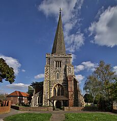
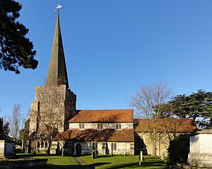
The Church of England parish church of St Mary the Virgin is a very old building. It has parts built in the Norman style and a chancel (the area around the altar) from the 14th century. Its west tower, built in the 15th century, has a spire covered with wooden shingles. Inside the church, you can find memorials to the Knyvet(t) family.
The church was repaired in 1862 and again in 1903. It is a Grade I listed building, meaning it is of exceptional historical interest.
Stanwell Place
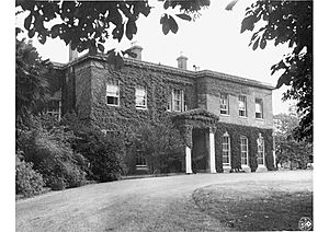
Stanwell Place was a large manor house from the 17th century, located about 0.5 miles (0.8 km) west of the village church. The Gibbons family owned the land rights from 1754 to 1933. They gradually sold off parts of the estate. In 1933, John Watson Gibson bought it. Four years later, 330 acres (1.3 km2) were sold to the Metropolitan Water Board to build the King George VI Reservoir.
After Gibson's death in 1947, Stanwell Place was sold to King Faisal II of Iraq, who owned it until his death in 1958. The estate was then bought for gravel mining. Despite efforts to save it, the house was left to fall apart and was torn down in the 1960s.
Economy and Businesses
The northern part of Stanwell is now a big area for industry, distribution, and company headquarters. Before World War I, there was not much building here. The first factory or warehouse appeared at Poyle before 1914, and another at West Bedfont in the 1920s. By 1956, there were many businesses in these areas. Along the main roads, like the A4 Bath Road and the A30 London Road, you can find garages and offices for companies like Del Monte, Ford, and Suzuki.
At one time, British Mediterranean Airways had its main office near Stanwell, though it was technically in the London Borough of Hounslow.
Getting Around Stanwell
The closest train stations are Ashford (Surrey) railway station, about 2 miles (3.2 km) south of Stanwell High Street, and Heathrow Terminal 4 railway station, about 2 miles (3.2 km) east. Heathrow Terminal 4 is also served by the Piccadilly line of London Underground, which is part of London's subway system.
Stanwell High Street itself has limited public transport, with buses running only once or twice a day. However, Clare Road, to the east of Stanwell, has regular bus services. London Buses route 203 runs between Hounslow and Staines, and route 442 runs between Heathrow Terminal 5 and Staines.
Population and Homes
| Output area | Detached | Semi-detached | Terraced | Flats and apartments | Caravans/temporary/mobile homes | Shared between households |
|---|---|---|---|---|---|---|
| Stanwell | 332 | 1,602 | 1,257 | 1,316 | 5 | 36 |
In Stanwell, about 22.4% of homes were owned outright (paid off), and 33.0% were owned with a loan. The rest were rented.
| Output area | Population | Households | % Owned outright | % Owned with a loan | Area (hectares) |
|---|---|---|---|---|---|
| Stanwell | 11,279 | 4,548 | 22.4 | 33.0 | 513 |
Famous People from Stanwell
- Thomas Knyvet, 1st Baron Knyvet: A Member of Parliament who was given Stanwell manor for finding out about the Gunpowder Plot in 1603.
- Nicholas Hilliard: A famous painter who leased Poyle Manor.
- James Nares: An English organist and composer, born in Stanwell in 1715.
- Richard Cox: A British gardener who created the Cox's Orange Pippin apple, first grown in his garden.
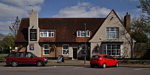
- Sir John Watson Gibson: A civil engineer who lived in Stanwell Lodge and then Stanwell Place. A local pub is named after him.
- Sir Allen Lane: The person who started Penguin Books, lived at Silverbeck, Stanwell Moor.
- King Faisal II of Iraq: Owned Stanwell Place from 1948 until his death in 1958.
- Gary Numan: A singer who grew up in Stanwell and went to Stanwell Secondary School.
- Pete Shaw: An author and theatrical producer who grew up in Short Lane, Stanwell.
 | Tommie Smith |
 | Simone Manuel |
 | Shani Davis |
 | Simone Biles |
 | Alice Coachman |


