Longford River facts for kids
Quick facts for kids Longford River |
|
|---|---|
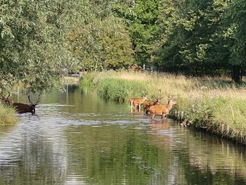
The Longford River as it enters Bushy Park, viewed from Hampton Hill High Street. The artificial bank of this otherwise natural looking waterway can be seen in the opposite direction.
|
|
| Country | England |
| Physical characteristics | |
| Main source | River Colne, Longford |
| River mouth | River Thames, Hampton Court |
| Length | 12 mi (19 km) |
The Longford River is a special kind of waterway that was built by people. It's like a long, narrow channel that takes water from one place to another. This river was made to bring water to Bushy Park and Hampton Court Palace and make them look beautiful.
It takes water about 12 miles (19 km) from the River Colne in Longford, near Colnbrook, England. The river's main exit is into the River Thames near Molesey Lock. Some smaller channels also flow into the Thames near Teddington Lock.
The Longford River was built for King Charles I in 1638 and 1639. Its main job was to supply water to Hampton Court. Later, in 1710, more water features were added in Bushy Park. The river's path has changed a few times, especially as London Heathrow Airport has grown. In 2009, the waterfalls, grassy banks, and fountains in Bushy Park were fixed up. They now look much like they did when they were first made.
Contents
Exploring the River's Path
In its northern part, the Longford River flows right next to its older "twin" river. This other river is called the Duke of Northumberland's River. Both rivers have been moved and re-dug. This was done to make space for Heathrow Airport.
River Diversions for Heathrow Airport
The most recent changes were part of a big project. It was called the Twin Rivers Diversion Scheme. This project made way for the taxiways and roads needed for Terminal 5. The rivers now flow along the southern edge of the airport. They split apart at a spot called 'Two Bridges'. This is just east of Terminal 4. The first time the rivers were moved was in the 1940s.
Journey Through Towns
After the airport, the Longford River flows southeast. It passes through towns like Bedfont, Feltham, and Hanworth. In Hanworth, it goes through two large underground tunnels called culverts. One culvert runs under a school, west of Hanworth Park. The other goes from the middle of the park to its eastern side.
The river then forms the border between Hampton and Hampton Hill. It even crosses over the deepest cutting of the Shepperton Branch Line. It does this on a short, brick bridge called an aqueduct.
Channels in Bushy Park
Once in Bushy Park, the river splits into many channels. One channel continues to fill the lakes at Hampton Court. There are three main places where the river flows into the Thames:
- East of Hampton Gate in Bushy Park.
- Under the Water Gallery at Hampton Court Palace Gardens. This is across from where the River Mole joins the Thames.
- Another spot east of that area, near a golf course and farm. This is across from Raven's Ait.
The Royal Parks Agency owns the river. This means they are responsible for keeping it clean and in good shape. Old rules, like signs from the early 1900s, made it clear. It was against the law to go onto the river's land without permission.
History of the Longford River
The Longford River was built between 1638 and 1639. King Charles I wanted it to bring more water to his Royal Parks. These parks were Bushy Park and Hampton Court.
Building the River
A person named Nicholas Lane designed the river. It took about nine months to build. The cost was around £4,000, which was a lot of money back then. Not everyone was happy about the river. In 1648 or 1649, someone illegally blocked it up. In 1653, people asked the authorities not to reopen it. They said it caused floods that harmed their crops and animals.
Bridges and Old Names
In Longford, a road called Bath Road crosses three rivers. These are the Duke of Northumberland's River, the Longford River, and the Colne. Bath Road used to be the main route from London to the southwest. Now, the A4 road bypasses it.
Longford Bridge carries Bath Road over the Duke's river. Moor Bridge carries it over the Colne. The first bridge over the Longford River was built when the river was made. It was torn down in 1648. But it was rebuilt by 1675. In the 1800s, it was known as Stone Bridge. The King was responsible for keeping it in good condition. By 1960, its name had changed to King's Bridge.
Before the 1900s, the Longford River had many different names. People called it the New River, the King's River, the Queen's River, the Cardinal's River, the Hampton Court Cut, and the Hampton Court Canal.
River Rerouting for Heathrow Terminal 5
Before Heathrow Airport Terminal 5 was built, the Longford River and the Duke of Northumberland's River flowed under the runways. They went through large tunnels. As part of the Terminal 5 project, the rivers were moved. They were rerouted into open channels around the western edge of the airport.
A new channel, about 3.7-mile (6.0 km) long, was built for each river. More than 75 percent of these channels were made from pre-made panels. These panels were built somewhere else and then brought to the site.
Encouraging Nature's Return
Even with this construction, people wanted to help nature thrive. They used special fences made of hazel branches. They also used rolls made of coir (coconut fiber). These were pre-planted with plants that naturally grow in the area. This helped create homes for small animals.
To help fish, they made the channels flow in a winding way. They used gravel and recycled trees to create good fish habitats. About 84,000 river plants were added to the channels. Animals like water voles, fish, and freshwater mussels were moved from the old riverbed to the new one. This helped the new river become lively again.
The landscaping involved planting many trees and shrubs. About 450 medium-sized trees, 2,000 shrubs, and 100,000 groundcover shrubs were planted. This big project took 18 months to finish. Now, a group called the Twin Rivers Management Committee manages it. This group includes people from Heathrow Airport, the Environment Agency, and the Royal Parks Agency. The project even won an award for its high environmental standards.
Water Features and Gardens
At its eastern end, the Longford River feeds the beautiful water features in Bushy Park and Hampton Court.
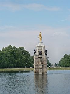
The Diana Fountain
To celebrate his queen, Henrietta Maria, King Charles I had a special statue and fountain made. Courtiers (people at court) called it the Diana Fountain. However, the fountain actually shows Arethusa, a water nymph. It's not the Roman goddess of hunting, Diana.
This fountain was moved from Somerset House to Hampton Court by Oliver Cromwell. Then, Sir Christopher Wren moved it to the center of its round pond in Bushy Park. He did this when he redesigned the gardens in 1713. The water gardens in Bushy Park were further developed in 1710 by the 1st Earl of Halifax.
Restoring Bushy Park's Water Gardens
During the First World War, Canadian soldiers were stationed in Bushy Park. In the Second World War, the USA Air Force used it. General Eisenhower was based there when the D-Day landings were planned. These landings started the Allied invasion of northwest Europe.
Most of the army huts were removed by 1963. But the park remained under military use. The Admiralty used it for research during the Cold War. By the early 1990s, when the military left, much of the park was overgrown and damaged.
A group called the Friends of Bushy and Home Parks was formed. They started to research what the park used to look like. They found an old painting from the 1700s and did archaeological digs. This helped them create a plan to restore the whole park. They received £7.2 million for the project. This money came from the Heritage Lottery Fund, the Royal Parks, and others.
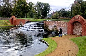
Work began in 2006. The main part of the project started in January 2008. This involved digging out a lot of mud from the ponds. They made the ponds their original shape again. They also fixed the water system to reconnect them to the Longford River. The waterfalls and side walls were repaired using original stones and bricks.
The Longford River had been moved by the Admiralty in 1953. This caused about 5 feet (1.5 m) of mud to build up in the ponds. When the mud was removed, two extra steps of the waterfalls were found! The river was put back on its old path. Water flowed down the waterfalls for the first time on September 15, 2008. A new bridge was built over the river to connect the Brew House to the water gardens. The beautiful Baroque water gardens reopened to the public in 2009. The cost to restore them was £780,000.
Hampton Court's Long Water
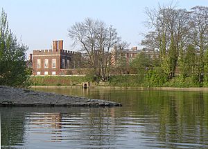
At Hampton Court, the most striking part of the grounds is the design created by Sir Christopher Wren. There's a semicircular garden area called a parterre that is surrounded by water. It runs along the east side of the palace.
Three long paths, called avenues, spread out like a crow's foot into Hampton Court Park. The middle path has a large canal. This canal is known as the Long Water. It was dug during the time of Charles II, in 1662. The design was very new for its time. It was inspired by the gardens at Versailles in France. Students of André Le Nôtre, who was Louis XIV's garden designer, laid it out.
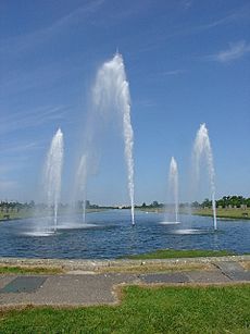
At the eastern end of the Long Water is the Golden Jubilee Fountain. Queen Elizabeth II opened this fountain in November 2002. It has five water jets. The biggest jet shoots water up to 98 feet (30 m) high!
River Water Quality
The Environment Agency checks the water quality of rivers in England. Each river gets an overall "ecological status." This status can be high, good, moderate, poor, or bad. Many things help decide this. These include the types and numbers of invertebrates (animals without backbones), flowering plants, and fish.
They also check the "chemical status." This compares the amount of different chemicals in the water to safe levels. Chemical status is rated as either good or fail.
Here's how the Longford River's water quality was in 2015:
| Section | Ecological Status | Chemical Status | Overall Status | Length |
|---|---|---|---|---|
| Longford River | Moderate | Good | Moderate | 10.0 miles (16.1 km) |
Places of Interest Along the River
| Point | Coordinates (Links to map resources) |
OS Grid Ref | Notes |
|---|---|---|---|
| Junction with River Colne | 51°28′51″N 0°29′32″W / 51.4809°N 0.4923°W | TQ047768 | Start of channel |
| Bridge for Terminal 5 access road | 51°27′46″N 0°29′20″W / 51.4629°N 0.4890°W | TQ050748 | Channel follows Heathrow Airport boundary |
| Duke of Northumberland's River diverges | 51°27′12″N 0°25′45″W / 51.4532°N 0.4291°W | TQ092738 | |
| Feltham Station bridge | 51°27′12″N 0°25′45″W / 51.4532°N 0.4291°W | TQ092738 | |
| Culvert under school | 51°26′33″N 0°24′08″W / 51.4424°N 0.4021°W | TQ111727 | |
| Culvert under Hanworth Park | 51°26′25″N 0°23′38″W / 51.4404°N 0.3938°W | TQ117724 | |
| Aqueduct over Shepperton Branch Line | 51°25′24″N 0°21′40″W / 51.4232°N 0.3612°W | TQ140706 | |
| Weir at entrance to Bushy Park | 51°25′17″N 0°21′15″W / 51.4214°N 0.3543°W | TQ145704 | |
| Western cascade into River Thames | 51°24′36″N 0°21′09″W / 51.4101°N 0.3526°W | TQ146691 | Opposite River Mole |
| Diana Fountain in Bushy Park | 51°24′36″N 0°20′11″W / 51.4100°N 0.3364°W | TQ158691 | |
| Main eastern sluice to River Thames | 51°23′59″N 0°18′39″W / 51.3996°N 0.3109°W | TQ175680 | By Ravens Ait |
 | Charles R. Drew |
 | Benjamin Banneker |
 | Jane C. Wright |
 | Roger Arliner Young |


