Longford, London facts for kids
Quick facts for kids Longford |
|
|---|---|
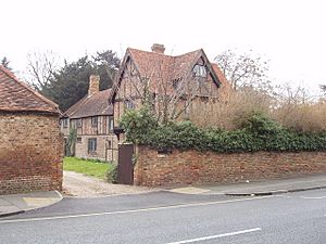
 King Henry's 'Public House' and The Stables, brick infilled timber-frame older homes |
|
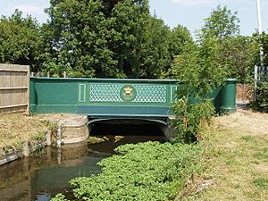
 Bridge over the 17th century-created Longford River |
|
| OS grid reference | TQ045765 |
| • Charing Cross | 15.8 mi (25.4 km) E |
| London borough | |
| Ceremonial county | Greater London |
| Region | |
| Country | England |
| Sovereign state | United Kingdom |
| Post town | WEST DRAYTON |
| Postcode district | UB7 |
| Dialling code | 01753 |
| Police | Metropolitan |
| Fire | London |
| Ambulance | London |
| EU Parliament | London |
| UK Parliament |
|
| London Assembly |
|
Longford is a small village in the London borough of Hillingdon, England. It is located right next to London Heathrow Airport, which is in the same area. Longford is the westernmost village in Greater London, very close to the borders of Berkshire and Surrey.
Longford used to be part of Harmondsworth for things like taxes and church matters. Since it has never had its own church, it can also be called a hamlet (a very small village). Until 1965, it was part of the old county of Middlesex. Longford is about 16 miles (25.5 km) west of Charing Cross in central London. It is also inside the M25 motorway, which forms its western edge near Colnbrook, Berkshire.
Contents
What's in a Name? The Story of Longford
The name Longford comes from two simple words: "long" and "ford." A ford is a shallow place in a river where you can cross by walking or driving. Longford got its name because of a wide ford across the River Colne, where the old Bath Road used to cross it. There was also a middle ditch and the Wraysbury River further west. People who lived there long ago used to say its name as "Long Ford," stressing both parts.
Longford's Past: A Journey Through Time

Longford grew up around this multi-channel ford of the River Colne and its smaller branches (called distributaries). These rivers made it tricky for travelers going to and from the west side of Middlesex on the old Bath Road from London.
Longford might have started as a small Saxon settlement between the 5th and 7th centuries AD. Some old buildings from the medieval and post-medieval times are still standing. We don't have much proof of Roman people living here, but archaeologists have found two Roman brooches (decorative pins).
In 1337, Longford was the only medieval settlement along the Bath Road in Middlesex and had 30 inhabited buildings. In Harmondsworth, a nearby area, there were 48 houses on Moor and Sheep Lanes.
In 1586, land on both sides of the river was made responsible for keeping Mad Bridge in good repair. This bridge carried the Bath Road over the river. Later, in the 18th and early 19th centuries, the Colnbrook turnpike trustees (people who managed toll roads) looked after it. They probably built the current bridge with cast-iron railings in 1834.
A map from 1754 by Rocque shows how the villages were set up. Longford, Harmondsworth, and Sipson had small groups of houses. At Heathrow, the houses were more spread out. In Longford, they lined both sides of the Bath Road, from the east bank of the Longford River to and across the Duke of Northumberland's River.
In 1819, a law called the common land inclosure (privatisation) Act came to Harmondsworth parish. This law divided up Harmondsworth's three open fields and large areas of common land, including Harmondsworth Moor and land around Heathrow. During this time, two sharp bends in the Bath Road in Longford were made straight.
By 1839, Longford, Harmondsworth, and Sipson shared one shop that served the whole area. In 1929, the Longford and Colnbrook bypass road was built to help with traffic.
In 1930, the Road Research Laboratory opened on the Colnbrook bypass. In the same year, the Fairey Aviation Company opened an airfield, the Great West Aerodrome, southeast of Heathrow village. Around 1930, a brickworks started east of Cain's Lane and Heathrow Road in Heathrow. Later, this site was mainly used for digging sand and gravel. After 1944, the airport took over the quarry and all traces of Heathrow village.
The Middlesex County Council built a large sewage treatment plant west of Perry Oaks farm. This plant was removed in the 1990s, and Heathrow Airport's Terminal 5 is now in its place.
In 1648, the first bridge over the newly built Longford River was taken down. It was replaced by 1675. In the 19th century, this bridge was called Stone Bridge, and the King (the Crown) was in charge of its upkeep, not a local group. By 1960, it was renamed King's Bridge.
Longford's Location and Landscape
Longford village is built in a line along the Bath Road. It is just north of Heathrow Airport and south of the M4. It is also right north of Heathrow's Western Perimeter Road. The area has an old village center and green areas that act as buffer zones (spaces that separate different areas).
The last bridge or ford to the west, over the Wraysbury River, used to mark the boundary of Colnbrook. Now, the M25 motorway has taken its place, and the road crosses over it. The Duke of Northumberland's River also runs from here to Isleworth; it was built around 1543.
Land and Height
Longford is almost always about 22 meters (72 feet) above sea level.
The soil in Longford is very rich. It is alluvial soil, which means it was deposited by rivers. Just south of the main street, gravel is close to the surface, except near the rivers and northeast of the village. Less fertile clay soil is found for many miles in other directions.
Getting Around: Transport in Longford
Just north of Longford is a special bypass road. This road connects the A4 to the M4 motorway. The M4 runs parallel to the A4 and has two junctions (exits) directly north of Heathrow Airport. The newer Junction 14, for Terminal 5, is only for airport roads.
The quickest way to get to the M25 motorway is to the south, at Junction 14 (Stanwell Moor).
The Bath Road (A4) is a very busy main road. So much traffic used it that a bypass for Longford and Colnbrook was built in 1928.
One bus route, the 81, serves the village. It is run by London Buses and travels from Hounslow to Slough along the old Bath Road.
Special Places: Longford's Landmarks
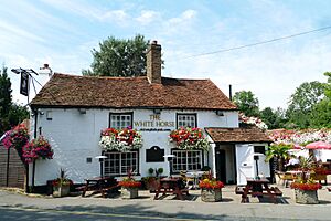
Longford still feels like an old-fashioned community. It has a former and a current public house (pub) that are listed buildings. This means they are important old buildings protected by law, mainly because of their age. An old building called Yeomans, which has been divided into three apartments, is also listed.
Other listed buildings include Longford Meeting House, Queen River Cottage and the next-door Willow Tree Cottage. King's Bridge is also listed; it's the main bridge built in 1834 at the very west end of the old Bath Road street. This bridge crosses the Longford River, which King Charles I had built to feed water to Bushy Park and Hampton Court Gardens. One of the listed cottages even has a traditional thatched roof (made of straw).
Protecting Longford: The Conservation Area
Much of the land around Longford village is part of the Metropolitan Green Belt. This is a special area where building is restricted to keep the countryside green. Many of Longford's buildings are in the Longford Village Conservation Area. This area was set up in 1988 to protect its special character, with a small change to its boundary in 1999. It includes seven listed buildings, one listed wall, and other unlisted properties that are important to the area's look and feel.
Future Changes: Heathrow's Proposed Runway
On July 1, 2015, the Airports Commission suggested that the government should approve a third runway for Heathrow Airport. This plan, called the Northwest Runway scheme, would mean that all buildings in Longford would need to be taken down. You can find more details about the steps for this proposed development on the Heathrow Expansion website.
Faith and Community: Religion in Longford
In 2011, in the local area that includes Longford, about 51.2% of people said they were Christian. Also, 11.9% were Muslim, 11% Sikh, and 1.9% Buddhist. About 13.3% said they had no religion, and 5.9% didn't state their religion.
The local Church of England parish is still in Harmondsworth at St Mary's.
- www.stmarysharmondsworth.com
The Catholic Church has a church in central West Drayton to the north. There are also three chaplains who serve St George's Chapel in Heathrow or the Sunday Mass at Terminals 4 and 5.
Gurdwaras (Sikh temples) are on Martindale and Hanworth Road in Hounslow, with one being Sri Guru Singh Sabha. The closest Islamic center is the Al-Falah Muslim Centre, on Tavistock Road in Yiewsley to the north.
 | Claudette Colvin |
 | Myrlie Evers-Williams |
 | Alberta Odell Jones |


