
River Crane, London facts for kids
Quick facts for kids Crane |
|
|---|---|

River Crane in Crane Park Whitton below the nature reserve and powder mills site
|
|

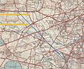
Map of 1930s showing most of the river, until shortly before its end (two points discharge to the Thames)
|
|
| Country | England |
| Counties | Greater London |
| Districts / Boroughs | London Boroughs of Hillingdon, Hounslow, Richmond upon Thames |
| Places with main adjoining parkland | Cranford, Hounslow Heath, Whitton |
| Physical characteristics | |
| Main source | Hayes, Hillingdon |
| River mouth | River Thames Isleworth |
| Length | 13.6 km (8.5 mi) |
| Discharge (location 2) |
|
| Basin features | |
| Tributaries | |
The River Crane is a river in west London, England. It is a tributary of the famous River Thames. The Crane flows for about 13.6 kilometers (8.5 miles).
It passes through three different areas of London. These are the London Borough of Hillingdon, the London Borough of Hounslow, and the London Borough of Richmond upon Thames. Even though many buildings are near the river, its old flood-meadows create a long, natural green space. Over the years, people have changed the river's shape. They have made it wider, narrower, straighter, and deeper.
Contents
Where Does the River Crane Flow?
The River Crane starts in Hayes, Hillingdon, south of North Hyde Road. From there, it flows in a curve, first south, then east. It eventually joins the River Thames near St Margarets and Isleworth. This meeting point is just south of Isleworth Ait.
Journey Through Parks and Towns
The river flows through Cranford and crosses Cranford Countryside Park. It then goes past the car parks of Heathrow Airport. These car parks used to be part of Cranford Heath. The river also passes North Feltham.
Near Hounslow West, another river, the (Upper) Duke of Northumberland's River, joins the Crane. After this, the Crane slowly turns east. It flows through Crane Park in Whitton, Twickenham.
Crane Park and Its History
Crane Park is home to the old Hounslow Powder Mills. These mills were built in the 1500s and made gunpowder until 1927. The mills are gone now, but the Shot Tower still stands nearby. A large pond on an island above the mills is now a special place called Crane Park Island. It is a Local Nature Reserve.
A smaller branch of the river, called the Lower Duke's River, splits off at Kneller Gardens. The main Crane river then flows northeast through central Twickenham. It continues north through the Cole Park area. The very last part of the river, between Cole Park Island and the Thames, is affected by the tides.
River Boundaries
The River Crane forms a natural border between several London boroughs:
- Hillingdon and Hounslow.
- Hounslow and Richmond upon Thames.
When the Piccadilly line underground train was extended to Heathrow Airport, engineers faced a challenge. The ground under the Crane had a lot of water. It was too hard to tunnel under the river. So, the train lines come out of their tunnels briefly and cross over the river on a bridge.

What Does "Crane" Mean?
The name of the river is linked to the nearby area of Cranford. It might come from the word "crane," like the large bird.
Other Rivers Connected to the Crane
The River Crane is connected to several other waterways.
Duke of Northumberland's River
This river was made by people and has two parts.
- The Upper Duke of Northumberland's River flows into the Crane. It starts from the River Colne, Hertfordshire at Longford and joins the Crane near Hounslow.
- The Lower Duke of Northumberland's River flows out of the Crane. It splits off from the Crane at Whitton and flows to the Thames at Isleworth.
Yeading Brook
The Yeading Brook is the upper part of the Crane. It is about 25.8 kilometers (16 miles) long. Before the 1800s, it was also called the River Fishbourne. It starts between Pinner and Harrow in northwest London. It also gets some water from the moat at Headstone Manor.
The Yeading Brook winds through North Harrow and parts of Ruislip. It then goes through the Ickenham Marsh nature reserve. After that, it flows past Northolt Aerodrome. South of the aerodrome, the Roxbourne Brook joins it. The Yeading Brook then flows southeast through parks, separating Yeading from Hayes. Finally, it turns south and flows through Bulls Brook Business Park in Hayes. This is its last section before it becomes the River Crane. This happens directly west of the A312 "The Parkway".
Other Smaller Streams
- The Ickenham Stream flows into the Yeading Brook. It was built in the early 1800s to carry water from a reservoir. This reservoir later became Ruislip Lido.
- Frogs Ditch flows from southwest Hayes. It goes under the M4 motorway. It then runs along the edges of Cranford Countryside Park. It joins the River Crane just before the Cranford Lane road bridge.
- The Whitton Brook flows into the River Crane at the Cole Park Allotments.
Working Together for the River
The Crane Valley Partnership (CVP) is a group that helps manage and improve the River Crane and its connected streams. They work to make the river better for wildlife and people. Their goals include improving water quality, helping nature, and making sure people can enjoy the river. They also want to highlight the river's history and offer learning chances.
How the Partnership Started
The CVP grew from an earlier group called the West London Biodiversity Practitioners Group. This group first met in 2002. Its early members included:
- London Borough of Hounslow
- London Borough Hillingdon
- Groundwork Thames Valley
- Syon Park Estate
- Thames Water
- Heathrow Airport Ltd
- Glendale/British Airways
- English Nature
- London Wildlife Trust (LWT)
- Royal Society for the Protection of Birds (RSPB)
Their main aim was to help with nature conservation in West London. This group then became the River Crane Management Forum in 2004. More organizations joined, like the Environment Agency and Greater London Authority.
In 2005, the Crane Valley Partnership (CVP) was officially formed. An educational charity called Green Corridor now hosts and leads the CVP. In 2013, the Partnership hired a Development Manager. This was made possible by money from Thames Water after an incident in 2011.
What the Partnership Does
The CVP includes five London boroughs and many other groups. These include public organizations, volunteer groups, and private companies. They all work together with a shared goal:
- To have a well-managed river area.
- To have a high-quality river that everyone can visit.
- To create a place where wildlife can thrive.
- To help local people feel proud of and care for the river.
Images for kids
-
Map from the 1930s showing most of the River Crane. The mouth on the right (east) is where the Crane naturally meets the Thames. The other one is the Lower Duke of Northumberland's River.
