
River Gipping facts for kids
Quick facts for kids River Gipping |
|
|---|---|

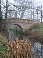
Bridge over the River Gipping, with Creeting Lock chamber beyond
|
|
| Specifications | |
| Maximum boat length | 55 ft 0 in (16.76 m) |
| Maximum boat beam | 14 ft 0 in (4.27 m) |
| Locks | 15 |
| Status | un-navigable river |
| History | |
| Date of act | 1790 |
| Date completed | 1793 |
| Date closed | 1934 |
| Geography | |
| Start point | Stowmarket |
| End point | Ipswich |
| Connects to | River Orwell |
The River Gipping is a river in Suffolk, England. It's the main source of the River Orwell. The river gets its name from the village of Gipping. It starts near Mendlesham Green and flows south-west to Stowmarket. From there, it continues south or south-east, passing through Needham Market and other villages. Finally, it reaches Ipswich, where it becomes the River Orwell.
For a long time, the River Gipping helped power many watermills. Some of these old mills are still standing today. The mill at Baylham is special because it still has most of its original machinery. It's the only complete mill left on the river.
People used the river for transport as early as the 1200s and 1600s. In 1790, a special law called an Act of Parliament was passed. This law allowed the river to be improved for boats from Ipswich to Stowmarket. To do this, 15 locks were built. The river then became known as the Ipswich and Stowmarket Navigation. This name isn't used much anymore.
The navigation opened in 1793 and seemed to be successful. Later, in the 1840s, railways started to appear. The people in charge of the river navigation made a deal with the Eastern Union Railway. They leased the river to the railway company for 42 years. When the lease ended, the river was in bad shape. Even though the railway was supposed to keep it maintained, they didn't.
Boat traffic to Stowmarket almost stopped. However, some barges still used the lower four locks. They served the Fison's and Packard's fertiliser factories at Bramford. By 1917, it was too expensive to keep the navigation open. It officially closed in 1922. After a period of neglect, a local group called the Inland Waterways Association suggested restoring it. Now, the River Gipping Trust leads this work. Several lock chambers have been fixed up. Also, the Gipping Valley River Path has been created along the old towpath. Many historic buildings, including locks, bridges, mills, and the Fison's factory warehouse, are found along the river.
Contents
People used the River Gipping a long time ago. Stone was carried on flat-bottomed boats to Rattlesden. This stone was used to rebuild Bury St Edmunds Abbey. The stone came from quarries in Northamptonshire. There's some debate about when this happened. It might have been for the original abbey building (1070-1095) or a rebuilding in the 1200s. We know for sure that Stowmarket church bells were taken down the river in the 1600s to be melted down and remade.
The first idea to make the river easier for boats came in 1719. But traders in Ipswich worried it would hurt their business, so it didn't happen. In 1789, six local gentlemen saw a problem. Transport was bad because roads were poorly kept. This meant fewer people and businesses in the Stowmarket area.
They hired William Jessop, an engineer, and Isaac Lenny to survey the river. A plan for a new law was put forward on February 17, 1790. This plan became an Act of Parliament on April 1, 1790. It created a group of six Trustees to manage the project. They could borrow £14,300 to pay for the work. The law also had a strange rule: boats on the river couldn't carry fishing gear. If they did, they could be fined £5!
The new company had its first meeting on April 19, 1790. Jessop was asked to draw up plans for the work. They also hired James Smith as a surveyor. They hoped to finish the navigation by October 1791. Dyson and Pinkerton were hired as contractors. These families were well-known for civil engineering projects.
Work began in 1790 at the Ipswich end of the river. But there were problems. The contractors, Dyson and Pinkerton, were fired for going onto land they weren't supposed to. This led to legal trouble, which caused delays and extra costs. Some work continued during the lawsuit. In January 1791, Smith set up a brickworks. A contract to build six locks was given to Samuel Wright in June. Because of the legal fight, materials couldn't be brought up the river by boat. They had to be carried over land to keep work going at the Stowmarket end.
The Trustees then asked another famous engineer, John Rennie the Elder, to check the project. He inspected the river in December 1791. He reported that the section between Stowmarket and Needham Market was almost done. He suggested that future locks should be made of brick. He also said that the first plans weren't detailed enough. He recommended a new survey to figure out exactly what work was needed.
Rennie gave another report in April 1792. He estimated it would cost £12,762 more to finish the project. He suggested building another 12 locks for £550 each. He also agreed that Jessop's original spot for connecting the navigation to the River Orwell was the best. He thought the timber locks should be rebuilt later, once the navigation was making money. He also recommended getting another Act of Parliament to raise more money.
This new law was passed on March 28, 1793. It allowed the Trustees to borrow an extra £15,000. The total cost of building the navigation was £26,263, which was almost double the first guess! The waterway was just under 17 miles (27 km) long from Ipswich to Stowmarket. It rose 90 feet (27 m) through 15 wide locks. Each lock was 55 feet (17 m) long and 14 feet (4.3 m) wide. This was big enough for barges that needed to float in 3 feet 4 inches (1.02 m) of water. The entire waterway opened on September 14, 1793.
The main things carried on the river were farm products going downstream. Coal and other heavy goods traveled upstream. At first, there were up to four barges working. The money collected from tolls (fees for using the river) was £460 in the first year. The number of barges then grew to 10.
However, frost and floods in early 1795 caused a lot of damage. £1,000 had to be spent on repairs. Even with this, the tolls for the year ending in July 1795 reached £937. Later, the Trustees didn't record all the money coming in. But they did note that barges were making over 30 trips each week in the early 1800s. Each trip took about seven hours.
Plans for Expansion
In 1791, the Trustees had asked John Rennie about extending the navigation to the River Lark at Bury St Edmunds. But this idea wasn't followed up. In 1819, when the navigation was doing well, there were two ideas for new canals from Ipswich to Eye, Suffolk. A meeting was held in Eye to discuss these plans.
One plan, by engineer William Cubitt, involved a tunnel and would cost over £100,000. Another plan for a canal over the hills would cost £80,000. Both were too expensive. A third idea came up: an extension from the River Gipping at Needham Market. This would follow a small river valley to Earl Stonham. A basin (a small harbor) would be built there next to the main road. This would let wagons from Eye make a round trip in one day instead of two. This plan was estimated to cost £12,000. Many people wanted to invest, but the plan never moved forward.
The River's Decline
In 1844, the Eastern Union Railway planned to extend its line from Ipswich to Stowmarket. The Trustees of the river navigation talked with the railway company about leasing the canal. They hoped this would help their investors and also prevent the railway from opposing their plans.
They made a formal offer to lease the canal on February 8, 1845, and the railway agreed. However, it was discovered that the original 1790 law actually said the Trustees couldn't lease the canal. So, both sides agreed to get new laws passed to allow the lease. The railway company would pay £1,070 per year for the first 21 years and £850 per year for the next 21 years.
The Trustees got a new law passed on June 26, 1846. This law included a rule that the railway company had to maintain the navigation. The House of Lords made sure this rule was very strong. It said the railway had to keep the river "in as good a state and condition as the same shall be at the time of passing of the Act."

The railway line opened in 1846. After this, traffic on the river dropped a lot. The condition of the waterway got worse. In 1869, the Railway Commissioners asked the Great Eastern Railway (which had taken over the Eastern Union Railway) to fix the damaged parts.
When the 42-year lease was almost over, the railway company refused to extend it. The river was in bad shape with very little boat traffic. Because of the rule in the 1846 law, the railway company offered the Trustees £2,000 instead of doing repairs. This was agreed on January 5, 1888, and the money was paid.
Trade on the upper part of the river to Stowmarket was very small. Only a few barges carried manure to Prentice's Manure Works. They returned with guncotton from an explosives factory. There was more traffic between Ipswich and Bramford. Barges regularly went to Fison's and Packard's factories. These companies paid lower tolls because they helped maintain the lock gates and clear weeds. 30-ton barges were pulled in pairs by steam-powered barges through the lower four locks.
By 1917, the river navigation was almost bankrupt. It was taking in about £220 per year but spending £480. There was no money left. The Trustees tried to save money. In May 1922, they decided to close the navigation from June 3, 1922. They officially closed it in 1932. The last meeting was held on March 16, 1934. Debts were paid, and any remaining money was split between the local council and the Catchment Board. The river then slowly fell into disrepair.
Restoring the River Gipping

In the 1970s, the Inland Waterways Association (IWA) started to get involved in improving the River Gipping. An article in a waterways magazine in 1979 showed how bad the navigation was. It said the IWA wanted to restore it so people could use it for fun. The group began by clearing the towpath. This led to the creation of the Gipping Valley River Path. This is a walking path from Ipswich to Stowmarket that mostly follows the old towpath.
Between 1993 and 2004, IWA members worked to rebuild Bosmere and then Creeting locks. Later, the chamber of Baylham lock was also restored, but no gates have been put in yet. Work has also been done at Pipps Ford to fix a bridge and the river channel around the lock.
Claydon lock was destroyed when the A14 trunk road was built. The river was moved into a new channel, and the old lock site is now under the road. Water levels on the river are controlled by special devices. Hawks Mill lock at Needham Market has an automatic gate. Paper Mill lock has an automatic tilting gate.
In 2007, the Inland Waterways Association decided it would be better to create a separate group to manage the river's restoration. So, the River Gipping Trust was formed in May 2007. It is a registered charity.
The River's Journey
The River Gipping starts in the village of Mendlesham Green. It begins north of the village, where water drains from fields. It flows south-west, passing under the main street of Mendlesham Green. Near here is Green Farm, a historic timber-framed farmhouse from the 1500s and 1600s.
The river continues past Great Gipping Wood and Old Newton Hall. Old Newton Hall is a very old building from the early 1600s. Near Stonebridge Ford, other streams join the river. One comes from Columbine Hall, a historic manor house built around 1400. Another stream flows from Old Newton. Near Bridge Farm, Newton Bridge carries the B1113 road over the river. The river then goes under a railway bridge. It is also joined by Haughley Watercourse, which flows from Haughley and Dagworth.
The river then turns south-east. It passes under the A14 Stowmarket Bypass and enters Stowmarket. It flows under Stowupland Street and Station Road. Just after Station Road bridge is The Maltings. This building was once a malthouse, but it was changed into a warehouse for the navigation. It has nine openings on the ground floor where chutes once loaded barges. It is now a restaurant and leisure center.
The Gipping Valley River Path runs along the east bank of the river. The Rattlesden River joins the Gipping from the west. Stowupland Lock was just below this junction. Beyond the lock, the river passes under the A1120 road bridge. Badley Mill House, a 1600s former mill-house, is nearby. The railway crosses the river again, and the site of Badley lock is close to Badley Mill Farm. This lock now works as a weir.
The River Jordan and Wattisham Watercourse join the Gipping. Near Needham Market are Hawks Mill and Needham Lock. The mill building was built in 1884. It still has a working water turbine, but the inside machinery is gone. An 18th-century bridge supports the road in front of it. Nearby are the remains of a windmill, moved here in 1880. It's thought to be the last of its kind in the country.
Needham Market sewage works is on the east bank. To the west are old gravel pits that have been turned into Needham Lake park. This park covers 32 acres (13 ha) and crosses the river. Parts of it are a special local nature reserve. The river splits into two just north of the B1078 bridge. The River Gipping is to the east, and the Old River is to the west. Bosmere lock is below the bridge. The four-story mill building here was once a restaurant and is now flats. Its iron water wheel remains, but the machinery is gone.
The Gipping Valley River Path moves to the west bank at the bridge. The next lock downstream is Creetings Lock. Riverside Farmhouse, built in 1798, stands on the east bank. The original Bosmere mill was nearby but was taken down in the early 1900s. Coddenham Watercourse joins the mill stream. The Old River then rejoins the main channel.
Pipps Ford Lock came next. Pipps Ford farmhouse, from the 1500s and 1600s, is to the east. The railway comes close to the river here. The Gipping Valley River Path briefly leaves the river to run beside the railway. It rejoins the towpath at Baylham Mill. This mill, built in the 1800s, has three stories. Most of its machinery is still there, making it the only complete water mill on the river. There's a red-brick bridge over the tail of the nearby lock.

East of the river, near the lock, is the site of Combretovium. This was a Roman site with two forts. Things found here include a bronze statue of Nero. After Shamford Lock, the river is crossed by the railway. Blakenham Lock is north of Great Blakenham. The Gipping Way moves back to the east bank at the lock. Nearby is a 19th-century house called Gipping Weir.
The river and railway cross again. To the east are large flooded gravel pits. At the south end of these, the site of Claydon lock is now under the A14 road. Further south was Paper Mill Lock, next to the paper mill. To the west is Suffolk Water Park, which is also flooded gravel pits.
To the south was the Fisons Horticultural Division warehouse. It was built around 1858 to make fertiliser. Edward Packard built the world's first superphosphate factory nearby between 1851 and 1854. The two companies joined soon after. Somersham Watercourse flows around the west side of Suffolk Water Park and joins the river. The factory closed in 2003 and was destroyed by a fire in 2019.
After another railway crossing, the river goes around the eastern edge of Bramford. It circles a hill where Sproughton Manor stands. This historic house was built in 1863. Sproughton Lock and mill are at the bottom of the hill. The mill is made of red brick and dates from the late 1700s. It worked until 1947, but all its machinery is gone. Parts of the mill house are from around 1600.
After passing under the A14 road, the river briefly heads north-east through Chantry Cut. Chantry Lock is here. The river then goes under the railway, which splits into two lines. A flood barrier is below the first bridge. Now flowing through Ipswich, the river also splits. The eastern branch is the River Gipping, and the western branch becomes the start of the River Orwell. A modern sluice (a gate to control water flow) is on the Orwell just below the split. A final weir (a small dam) marks where Handford Sea Lock used to be. Below this, the two channels rejoin. After an outfall (where water flows out), the river becomes tidal, meaning its level changes with the ocean tides.
Little Gipping
Just north of the Handford Sea Lock weir, a freshwater channel goes to the east. This channel was built by people, possibly as far back as Roman times. It has had different names over the years, but it's best known as the Little Gipping. Much of it has been filled in. What's left is an important part of the Alderman Canal West and Alderman Canal East, which are two Local Nature Reserves.
River Water Quality
The Environment Agency checks the water quality of rivers in England. Each river system gets an overall "ecological status." This can be high, good, moderate, poor, or bad. This status is based on things like the number and types of invertebrates (bugs), plants, and fish. They also check "chemical status," which compares chemical levels to safe limits. Chemical status is either good or fail.
In 2016, the water quality of the River Gipping system was mostly "moderate" for ecological status and "good" for chemical status.
The reasons why the quality isn't "good" include:
- Sewage discharge (waste water) affecting most of the river.
- Physical changes to the river channels.
- Taking too much water from underground sources.
- Poor management of farmland and rural areas next to the river.
Images for kids
-
Bridge over the River Gipping, with Creeting Lock chamber beyond
-
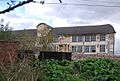
Part of Fison's factory, built in 1858, which shipped fertiliser down the navigation.
-
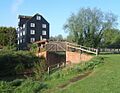
Bosmere Mill, with the restored lock chamber to the right.
-
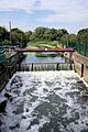
A weir has replaced the gates at Handford Sea Lock.
| Point | Coordinates (Links to map resources) |
OS Grid Ref | Notes |
|---|---|---|---|
| Source at Mendlesham Green | 52°13′52″N 1°04′12″E / 52.2310°N 1.0699°E | TM097636 | |
| First crossing under railway | 52°12′09″N 0°59′32″E / 52.2025°N 0.9922°E | TM045602 | Jn with stream from Dagworth |
| The Maltings (warehouse) | 52°11′21″N 0°59′55″E / 52.1892°N 0.9987°E | TM050587 | |
| Site of Stowupland Lock | 52°10′55″N 1°00′27″E / 52.1819°N 1.0074°E | TM057580 | |
| Badley Lock | 52°10′14″N 1°01′49″E / 52.1706°N 1.0304°E | TM073568 | |
| Needham Lock | 52°09′30″N 1°03′10″E / 52.1584°N 1.0527°E | TM089555 | |
| Bosmere Lock | 52°09′02″N 1°03′45″E / 52.1506°N 1.0625°E | TM096546 | |
| Creeting Lock | 52°08′48″N 1°04′32″E / 52.1468°N 1.0756°E | TM105542 | |
| Pipps Ford Lock | 52°08′27″N 1°04′40″E / 52.1409°N 1.0777°E | TM107536 | |
| Baylham Lock | 52°07′57″N 1°05′06″E / 52.1324°N 1.0851°E | TM112527 | |
| Shamford Lock | 52°07′33″N 1°05′35″E / 52.1258°N 1.0930°E | TM118520 | |
| Blakenham Lock | 52°06′57″N 1°05′37″E / 52.1157°N 1.0935°E | TM119508 | |
| Site of Claydon Lock | 52°06′35″N 1°06′21″E / 52.1097°N 1.1058°E | TM127502 | |
| Paper Mill Lock | 52°05′29″N 1°06′07″E / 52.0915°N 1.1019°E | TM125482 | |
| Bramford Lock | 52°04′34″N 1°06′08″E / 52.0762°N 1.1022°E | TM126465 | |
| Sproughton Lock | 52°03′50″N 1°05′54″E / 52.0640°N 1.0983°E | TM124451 | |
| Chantry Lock | 52°03′28″N 1°06′36″E / 52.0579°N 1.1101°E | TM133445 | |
| Rapier sluice | 52°03′33″N 1°08′04″E / 52.0592°N 1.1344°E | TM149447 | to River Orwell |
| Handford Sea Lock | 52°03′18″N 1°08′18″E / 52.0551°N 1.1382°E | TM152442 |
