
Baylham facts for kids
Quick facts for kids Baylham |
|
|---|---|
 Baylham Church |
|

Baylham
|
|
| Population | 300 (2021 census) |
| OS grid reference | TM106515 |
| District | |
| Shire county | |
| Region | |
| Country | England |
| Sovereign state | United Kingdom |
| Post town | Ipswich |
| Postcode district | IP6 |
| Dialling code | 01473 |
| EU Parliament | East of England |
Baylham is a small village and civil parish in Suffolk, England. It's about 7 miles (11 km) northwest of Ipswich and 6 miles (10 km) southeast of Stowmarket. The village covers an area of about 1,349 acres.
Most of Baylham's buildings are found along Upper Street and Church Lane. The village is surrounded by other parishes like Barking, Darmsden, Nettlestead, Coddenham, and Great Blakenham.
Contents
A Look Back: Baylham's History
How Old Is Baylham?
The oldest signs of people living in Baylham go back to the Neolithic Age (New Stone Age), between 9,000 and 4,000 BC. During an excavation in 2007-2008, archaeologists found an ancient pit with flint pieces and ditches. This suggests there might have been a burial ground (barrow cemetery) and early farming fields here.
Roman Times: Combretovium
At the end of Mill Lane, near the River Gipping, remains of two Roman forts and a small settlement have been found. These date from the late Iron Age and the time of Emperor Claudius (around 43 AD) up to the mid-4th century. This area was known as Combretovium.
The first fort was smaller, covering about 5.3 acres. It was inside a larger military area of 14.5 acres. Other Roman finds were spread over a much wider area of 148 acres. Even though no buildings are left, many items have been found. These include a broken statue of Emperor Nero and a saddle-cloth weight. This shows that many Roman soldiers were once here.
Combretovium was important because it was a crossing point over the River Gipping. It was on the Pye Road, a major Roman road from London to Caistor St Edmund. This made it a useful place for the Roman army to gather, especially when they fought against the Iceni tribe. Archaeologists also found old hut circles, rubbish pits, and pottery, suggesting people lived here for a long time.
The Middle Ages
After the Romans left England, Anglo-Saxons likely settled along the River Gipping. Anglo-Saxon jewelry from the 7th or 8th centuries has been found in Baylham. The river was also used for travel around 800 AD, when the Danes sailed up it.
The first written record of Baylham is from 1085. It's listed in the Domesday book as Beleham, which means "Fair/Gentle Enclosure" in Old English. The Domesday Book was a huge survey ordered by William The Conqueror to record who owned what in England. Baylham had 37 households and a shared church, making it one of the larger settlements back then. It had many animals, including 130 sheep, 40 pigs, and 13 cattle.
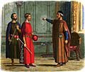
After the Norman Conquest in 1066, a knight named Roger Bigot became the main owner of Baylham. He was loyal to William the Conqueror and was given control of many places in Suffolk and Norfolk.

Control of Baylham stayed with the Earls of Norfolk for a long time. Later, in 1306, the land went back to the King, King Edward I. Important families like the de Weylands and de Bournevilles also lived in Baylham during this time.
During the black death in the 14th century, Baylham's population dropped. Only 20 taxpayers were recorded in 1327, and this number stayed low for many years. Around this time, the main part of the village church was also built and expanded.
Towards the end of the 14th century, a family called Andrew became important. James Andrew was a well-known person who worked for the Earl of Suffolk. In 1434, a disagreement over land in Baylham caused a big problem for James. This led to serious tensions between the Earl of Suffolk and the Duke of Norfolk, so much so that the King's Council had to step in to stop large-scale violence.
James's son, John, also became a supporter of the Earl and served in Parliament for Ipswich.
Early Modern Times
Many of Baylham's old buildings that are still standing today were built in the 15th and 16th centuries. These include the Millhouse, Baylham House Farm, and White Wheat Farm.
The Windsor family owned the manor of Baylham until the 17th century. On John Speed's map from 1610, the village is called Baleham. Later, John Acton bought the manor. He built Baylham Hall. However, the village faced hard times after the English Civil War. John Acton was thought to support the King, even though Suffolk was mostly on the side of Parliament. Many families in Baylham became very poor because they had to pay large fines.

Not everyone in Baylham was affected by the war in the same way. Baylham House Farm was home to William Dowsing, a famous Puritan who went around destroying religious images he thought were wrong. He lived there from at least 1642 to 1661.
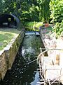
Baylham's farming industry got a boost in the late 1700s. The River Gipping was made into a canal from Stowmarket to Ipswich by engineer John Rennie. This made it easier to transport goods to and from the village's millhouse. You can still see parts of Rennie's original designs today.
Modern Baylham
Baylham remained a farming village into the 20th century. In 1831, 55 people worked on the land, and six worked in shops. The population grew to 310 in 1851 but then slowly decreased to 215 in 1981.
In 2002, Baylham Mill became famous for a surprising reason. A lost painting by the famous artist Nicolas Poussin, called The Destruction And Sack Of The Temple Of Jerusalem, was found there! A man named Ernest Onians, who lived at the mill, had bought the painting years ago, not knowing how valuable it was. After he died, the painting was mistakenly sold for a low price by an auction house. It was later discovered to be a masterpiece and was sold for a huge amount of money to the Rothschild foundation. The painting is now in the Israel Museum in Jerusalem.
In the 2010s, efforts were made to re-open the River Gipping for walking and boating. Baylham's sluice gates and lock were restored in 2013 and 2016.
The number of homes in Baylham has grown quite a bit since 2000, and the population increased by about 16% by the 2021 census.
What Does Baylham Do? (Economy)
Baylham has always had a strong farming economy. In the 11th century, sheep farming was important. From the 16th century onwards, farmers grew many different crops, with barley being a main one. Today, wheat, barley, and peas are common crops, and some land is used for horse pastures.
Besides the famous Baylham Rare Breeds Farm, other farms in the area include White Wheat Farm, Yew Tree and Hill Farm, and Moat Farm.
Modern businesses in Baylham include a garage and the Baylham Care Centre, a nursing home for people over 65. The care centre was in the news in 2014 for its special way of helping people with dementia, which included building a small replica village for residents. The Baylham Business Centre also has Eastern Region Training, a place where people learn about health and safety in construction.
Many of the village's older businesses, like the quarry, blacksmith, shoemaker, post office, and local shop, have now closed and become homes.
How Baylham Is Run (Governance)

In the past, Baylham was part of a system called "hundreds," specifically Bosmere. After the Norman Conquest, it became part of Bosmere and Claydon.
Today, Baylham is part of the Needham Market ward in the Mid Suffolk district council. The village is represented in the national Parliament by the MP for Central Suffolk and North Ipswich.
At a local level, Baylham has an active parish council that helps manage local matters.
Getting Around Baylham (Transport)
The 88 bus route, which goes from Ipswich to Stowmarket, stops at the bottom of the hill in Baylham. The closest train station is in Needham Market.
You can also walk along the River Gipping through Claydon to Bramford and Ipswich.
Who Lives in Baylham? (Demography)
The current population of Baylham is 300 people.
Before modern censuses, records of how many people lived in Baylham were not always consistent. They sometimes counted households or taxpayers instead of individuals. Since 1801, the census has counted all inhabitants.
Population Over Time
| Year | 1086 | 1327 | 1524 | 1603 | 1674 |
|---|---|---|---|---|---|
| Population | 38 | 20 | 20 | 80 | 35 |
| Year | 1801 | 1831 | 1851 | 1871 | 1901 | 1931 | 1951 | 1971 | 1981 | 2001 | 2011 | 2021 |
|---|---|---|---|---|---|---|---|---|---|---|---|---|
| Population | 232 | 238 | 310 | 275 | 255 | 249 | 218 | 239 | 215 | 251 | 266 | 300 |
All numbers are from Heritage Suffolk and ONS census data.
Important Places (Landmarks)

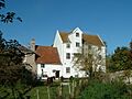
Baylham is in a Special Landscape Area. It's most famous for its old millhouse, built in the early 16th century. This millhouse has been featured in paintings by artists like Graham Bell and David Gentleman. Today, it's a private home. The bridge and watermill nearby were built later, in the 18th and 19th centuries.
Close by is Baylham House Farm, also known as Baylham Rare Breeds Centre. This 50-acre farm is built on the site of the old Roman settlement. While you won't see Roman ruins, you can find artifacts on display in the farm shop. Parts of the farmhouse itself are from the 16th century, and it was once home to William Dowsing.
Baylham Hall is a large manor house from the early 17th century. It's a Grade II* listed building, which means it's very important historically. Baylham Common is a green space near the church.
Column Field Quarry, also called Masons Quarry, is on the border between Baylham and Great Blakenham. It used to be a chalk pit for cement works but closed in 1999. Parts of it are now unused or used for landfill. There have been plans to develop it, including for a winter sports facility, but these have faced challenges.
On the edge of the parish, you'll find Tarston Hall, a Grade II listed building with a medieval double moat. Tarston Hall was likely built in the 16th century.
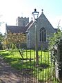
The Church of St Peter
The Church of St Peter is located on a hill at the west end of the village. It was first built in the 12th century in a Romanesque style. Later, in the 14th and 15th centuries, Gothic-style windows were added. Some of its original decorations survived the English Reformation and William Dowsing's inspections, though some animal figures were damaged. An alabaster carving of the crucifixion, hidden during Dowsing's time, was found and put back in the church in 1774.
The church was restored in the 1870s by Revd W E Downes, who hired architect Frederick Barnes for the work. Barnes also designed the railway stations in Needham Market and Stowmarket.
.jpg)
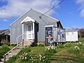
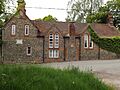
Two buildings that were once part of the church's property are the old vicarage (where the priest lived) and a village school. The school, founded in 1860, taught about 70 students from Baylham and nearby villages. It closed in the late 1960s, and both buildings are now private homes.
Famous People from Baylham
- William Acton (c. 1684–1744): A Member of Parliament for Orford.
- James Andrew (died 1434): A Member of Parliament for Ipswich.
- John Andrew (1421-1473): Also a Member of Parliament for Ipswich and Bletchingley.
- William Dowsing (c. 1596–1668): An important Puritan figure who removed religious images from churches.
- Katherine Rednall (born 1996): The youngest-ever World Indoor Bowls Champion.
Baylham's Environment (Geography)
Weather in Baylham (Climate)
The British Isles have a maritime climate, which means cool summers and mild winters. East Anglia, where Baylham is, is a bit warmer and sunnier in summer and colder and frostier in winter than other parts of Britain, with less rain.
The closest weather station to Baylham is at Wattisham Airfield, about 4.4 miles (7 km) away. Temperatures there usually range from 1°C to 22°C. It rarely gets colder than -3°C or hotter than 27°C.
| Climate data for Wattisham Airfield | |||||||||||||
|---|---|---|---|---|---|---|---|---|---|---|---|---|---|
| Month | Jan | Feb | Mar | Apr | May | Jun | Jul | Aug | Sep | Oct | Nov | Dec | Year |
| Mean daily maximum °C (°F) | 6 (43) |
7 (45) |
9 (48) |
12 (54) |
16 (61) |
18 (64) |
21 (70) |
21 (70) |
18 (64) |
14 (57) |
10 (50) |
7 (45) |
13 (56) |
| Daily mean °C (°F) | 4 (39) |
4 (39) |
6 (43) |
8 (46) |
12 (54) |
14 (57) |
17 (63) |
17 (63) |
14 (57) |
11 (52) |
7 (45) |
5 (41) |
10 (50) |
| Mean daily minimum °C (°F) | 2 (36) |
1 (34) |
3 (37) |
4 (39) |
7 (45) |
10 (50) |
12 (54) |
12 (54) |
10 (50) |
8 (46) |
4 (39) |
2 (36) |
6 (43) |
| Average precipitation mm (inches) | 39.7 (1.56) |
31.2 (1.23) |
30.2 (1.19) |
29.4 (1.16) |
37.1 (1.46) |
42.9 (1.69) |
37.1 (1.46) |
38.1 (1.50) |
39.5 (1.56) |
49.7 (1.96) |
45.8 (1.80) |
43.7 (1.72) |
464.4 (18.29) |
| Source: Met Office | |||||||||||||
Land and Rocks (Geology and Topography)
While much of Suffolk is flat, Baylham is in an area of Cretaceous chalk that runs along the Gipping Valley. The land rises from 10 meters above sea level near the river to 73 meters at Baylham Hall.
You can find sand and gravel on the valley floor. The soil on the hill is a mix of loam, sandy soil, and clay, sitting on top of chalk rock.
Animals and Plants (Wildlife)
Besides great crested newts, Grey Wagtails are known to nest in old river structures along the Gipping, including at Baylham Lock. Recently, Mistle Thrush and the Greater white-fronted goose have also been seen in the area.
Images for kids
-
Baylham Church
-
Roger Bigod, 5th Earl of Norfolk, was a powerful figure who challenged King Edward I.
-
Baylham Lock
-
Baylham Village Hall. This hall hosts regular events.
-
Baylham Mill
-
The School House, Baylham
