Roman River facts for kids
Quick facts for kids Roman River |
|
|---|---|

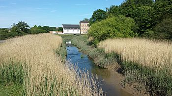
The Roman River above the former tide mill and granary at Fingringhoe
|
|
|
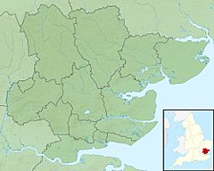
Location of the river mouth within Essex
|
|
| Country | England |
| County | Essex |
| Physical characteristics | |
| Main source | west of Great Tey 58 m (190 ft) 51°53′42″N 0°42′15″E / 51.8951°N 0.7041°E |
| River mouth | River Colne opposite Wivenhoe 0 m (0 ft) 51°51′13″N 0°57′15″E / 51.8537°N 0.9541°E |
| Basin features | |
| River system | River Colne |
| Tributaries |
|
The Roman River is a river in Essex, England. It flows into the River Colne near Colchester. The lower part of the Roman River is affected by tides, meaning the water level goes up and down with the sea.
Long ago, the river was very important for powering mills. These mills used the river's flow to grind things like grain. One special mill was a tide mill at Fingringhoe. It used the power of the incoming and outgoing tides. Another was a traditional watermill at Layer de la Haye, which was even mentioned in the old Domesday Book.
The Roman River has two main smaller rivers that flow into it: the Birch Hall Brook and Layer Brook. Layer Brook used to help fill Abberton Reservoir. This reservoir is super important for wildlife and has special protections to keep it safe. You can even visit a center there to see lots of birds!
Contents
Where Does the Roman River Flow?
The Roman River starts from natural springs west of Great Tey. Several small streams join together to form the river. It then flows under roads and railway lines. One big bridge carries both the Great Eastern Main Line railway and the A12 road over it.
The river then turns southeast, passing by Heckfordbridge. A smaller stream from Birch joins it. The river then turns east, flowing under Kings Ford Bridge. Here, the river gets wider, forming a pond for the old Layer de la Haye watermill. Next to the river is Roman River Valley, a nature reserve managed by the Essex Wildlife Trust.
Further along, the river flows past Friday Wood. This area is special because it has rare types of grassland and is home to over 1000 kinds of moths and butterflies! It's part of the Roman River SSSI, which means it's a "Site of Special Scientific Interest" and protected.
The Layer Brook, which flows out of Abberton Reservoir, joins the Roman River. After this point, the Roman River becomes tidal. It then flows through Donyland Wood, another protected area. Finally, the river winds its way east, passing under a bridge at Fingringhoe, and then joins the River Colne across from Wivenhoe.
Layer Brook: A Key Tributary
The Layer Brook is the main stream that feeds the Roman River. It starts near Tiptree Heath. It flows northeast and then southeast, entering Abberton Reservoir.
Abberton Reservoir is a huge lake that holds water. It's incredibly important for wildlife, especially birds. It's a protected area known as a Ramsar site (for wetlands) and a Special Protection Area (for migratory birds). In 2009, the reservoir was made even bigger by raising its water level. This created more space for the thousands of birds that visit every year. There's a visitor center run by the Essex Wildlife Trust where you can watch the birds.
The Layer Brook continues flowing after the reservoir's dam. It then joins the Roman River near the village of Abberton.
The History of Mills on the River
The Roman River was once a busy place with several mills. These mills used the river's power to do work.
Fingringhoe Tide Mill
The Fingringhoe Mill was a special tide mill. This means it used the power of the ocean's tides. When the tide came in, it filled a pool behind the mill. As the tide went out, the water flowed from the pool through a channel, turning a big waterwheel. This allowed the mill to work for several hours each tide.
The first mill here was built around 1520. The building you see today is from the late 1700s or early 1800s. It was used to grind flour, and later, animal feed. In 1936, the mill burned down but was rebuilt. The waterwheel was removed in the 1950s.
In 1997, the mill building and a nearby granary (where grain was stored) were restored. They were turned into homes and even won an award for the best restoration!
Layer de la Haye Watermill
Further upstream was a traditional watermill at Layer de la Haye. This mill was first mentioned in the Domesday Book, a famous survey from 1086! The mill was owned by a powerful lord, and local farmers had to pay him to grind their corn there.
Over the centuries, different families owned and ran the mill. By 1923, it was still grinding corn. Later, it was used to grind products for a mushroom farm nearby. In 1960, the mill was turned into a house, and its machinery was removed.
Other Mills on the River
There were two other smaller mills on the Roman River, but almost all traces of them are gone. These were fulling mills, which were used to process cloth, especially wool.
- Stanway Mill was on the main river channel.
- Birch Mill was on a smaller stream that flowed into the Roman River.
These mills were important for the local people. However, as fewer people lived in the valley, these mills stopped working. Birch Mill closed between 1770 and 1810, and Stanway Mill in the early 1800s. Today, you can barely find any signs that they ever existed.
River Health: Water Quality
The Environment Agency checks the health of rivers in England. They give each river an "ecological status" (how healthy the environment is) and a "chemical status" (how clean the water is from chemicals).
- Ecological Status: This looks at things like the types of bugs, plants, and fish living in the river. It can be high, good, moderate, poor, or bad.
- Chemical Status: This checks for harmful chemicals. It's either good or fail.
The Roman River is considered "heavily modified." This means people have changed its natural shape, for example, by building things along it.
In 2015, the Roman River's water quality was:
| Section | Ecological Status | Chemical Status | Overall Status | Length | Catchment |
|---|---|---|---|---|---|
| Roman River | Moderate | Good | Moderate | 12.1 miles (19.5 km) | 23.59 square miles (61.1 km2) |
| Colne (inc part of Roman River) | Moderate | Good | Moderate |
This table shows that in 2015, the Roman River had a "moderate" ecological status and a "good" chemical status. This means there's still work to do to make the river even healthier for all the plants and animals that live there.
Points of Interest Along the River
| Point | Coordinates (Links to map resources) |
OS Grid Ref | Notes |
|---|---|---|---|
| Source of Roman River | 51°53′42″N 0°42′15″E / 51.8951°N 0.7041°E | TL861252 | |
| Source of Roman River | 51°53′00″N 0°43′46″E / 51.8832°N 0.7294°E | TL879240 | |
| Crossing under railway and A12 road | 51°53′02″N 0°47′44″E / 51.8840°N 0.7955°E | TL924242 | |
| Source of Birch Hall Brook | 51°50′15″N 0°47′51″E / 51.8374°N 0.7975°E | TL928191 | |
| Junction with Birch Hall Brook | 51°51′25″N 0°50′28″E / 51.8569°N 0.8412°E | TL957214 | |
| Source of Layer Brook | 51°48′30″N 0°43′18″E / 51.8084°N 0.7217°E | TL877157 | |
| Layer Brook enters Abberton Reservoir | 51°48′47″N 0°49′02″E / 51.8130°N 0.8171°E | TL942164 | |
| Layer Brook joins Roman River | 51°50′39″N 0°53′52″E / 51.8441°N 0.8978°E | TL997201 | |
| B1025 Manwood Bridge | 51°50′44″N 0°55′06″E / 51.8456°N 0.9182°E | TM011203 | Tidal below here |
| Fingringhoe Tide Mill | 51°50′49″N 0°56′46″E / 51.8470°N 0.9460°E | TM030205 | |
| Junction with River Colne | 51°51′13″N 0°57′17″E / 51.8537°N 0.9546°E | TM035213 |
 | Kyle Baker |
 | Joseph Yoakum |
 | Laura Wheeler Waring |
 | Henry Ossawa Tanner |


