
Rosetta Head facts for kids
Quick facts for kids Rosetta HeadSouth Australia |
|
|---|---|

Rosetta Head, west side
|
|

Rosetta Head
Location in South Australia
|
|
| Postcode(s) | 5211 |
| Elevation | 97 m (318 ft) |
| LGA(s) | City of Victor Harbor |
Rosetta Head, also known as Kongkengguwar by the Ramindjeri people, is a well-known piece of land that sticks out into the sea. Most people call it The Bluff. It is located on the south coast of the Fleurieu Peninsula in Encounter Bay, South Australia. This area is part of the City of Victor Harbor.
Rosetta Head is a famous landmark on the coast. It is about 77 kilometers (48 miles) south of Adelaide, the capital city. Today, it is a popular place for people to visit and enjoy outdoor activities.
Contents
What is Rosetta Head Like?
Rosetta Head is found in the area called Encounter Bay. It is about 3.9 kilometers (2.4 miles) southwest of the center of Victor Harbor. It is also about 77 kilometers (48 miles) south of Adelaide.
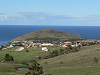
If you see it from a ship, it looks like a grassy hill that is 97 meters (318 feet) high. Its eastern side has cliffs and is covered with large granite rocks. The eastern and southern sides are very steep.
The southern tip of Rosetta Head marks the western edge of Encounter Bay. On its northern side, there is a small wharf. A road connects this wharf to the nearby town. The water next to the wharf is called Rosetta Harbor. On the southern side, there is a small bay known as Petrel Cove.
How Was Rosetta Head Formed?
Rosetta Head was shaped over thousands of years. It became a headland when the sea reached its current level about 7,500 years ago. This happened after sea levels started to rise at the beginning of the Holocene period.
This landform is a large, rounded hill that stands alone. It is considered the most noticeable feature along the Encounter Bay coastline. Its unique shape comes from two main geological processes. First, molten granite pushed into older rocks and changed them. Second, it was shaped by two stages of erosion. A glacier moving north during the Permian period created its distinct dome shape. Later, ocean waves from the south, caused by rising sea levels, further shaped it.
When seen from the nearby coast, Rosetta Head looks like a typical example of a glacial landform called a roche moutonnee. This means it looks like a rock shaped by a glacier.
Geologically, Rosetta Head was formed when hot, melted rock (called Encounter Bay Granite) pushed into a gray metamorphic rock. This happened between 475 and 500 million years ago. Later, this area was lifted up as part of a mountain-building event called the Delamerian Orogeny.
The water at the base of Rosetta Head gets deep very quickly. It drops to a maximum depth of 12.8 meters (42 feet) within just 100 meters (328 feet) of the shore.
A Look at Rosetta Head's Past
Who Lived Here First?
The Ramindjeri clan of the Ngarrindjeri people are the traditional owners of Encounter Bay. However, some experts suggest that the Kaurna people's traditional lands might have reached as far east as Encounter Bay. It is thought that the Ramindjeri moved into Encounter Bay in the late 1830s because of whalers in the area.
In 1836, Colonel Light and his group met people at Rapid Bay. These "Encounter Bay people" spoke the Kaurna language.
European Exploration and Use
Rosetta Head was once the site of a whaling station. The top of the headland was used as a lookout point to spot whales in the ocean. This station started in 1837 and was used until the early 1860s.
A small wharf, a sea wall, and a connecting road were finished in 1856. The South Australian Government built these to help the whaling industry. The wharf was called the "Lilliputian Jetty" because it was quite small. It was 12.7 meters (42 feet) wide and 4.6 meters (15 feet) deep.
In 1863, a mine was opened on Rosetta Head to look for copper and other minerals. However, this mining project was stopped in 1866.
On April 8, 1902, a special plaque was placed on a granite rock near the top of Rosetta Head. The Governor of South Australia, Baron Tennyson, unveiled it. This plaque celebrates 100 years since the European explorers, Matthew Flinders and Nicolas Baudin, met in the nearby waters.
How Rosetta Head Got Its Names
The Ramindjeri language name for Encounter Bay was Ramong. Some people believe this name also referred to The Bluff itself. However, the name Kongkengguwar is more commonly used for The Bluff.
Rosetta Head received its modern name in 1839. It was named after Rosetta French, the wife of George Fife Angas. It is believed that George Gawler, the second Governor of South Australia, gave it this name. The name "The Bluff" is the most common name for the headland today. Whalers working in the area used this name before Rosetta Head was officially named.
Protected Status of Rosetta Head
Rosetta Head has been recognized for its special importance. It was listed on the now-closed Register of the National Estate on October 21, 1980. It was also listed on the South Australian Heritage Register on September 1, 1983. These listings help protect its natural and historical value.
What Can You Do at Rosetta Head Today?
Rosetta Head is now a public recreation area. The City of Victor Harbor manages it. There is a walking trail that goes up to the top. From the summit, you can see amazing views of the coast, including the town of Victor Harbor and nearby islands.
Between May and November, it is a great place to watch for southern right whales in the nearby waters. As of 2007, there was a plan to connect the Rosetta Head walking trail to the Heysen Trail to its west. This new trail would follow the coastline.
A sandy beach on the north side of Rosetta Head is a good spot for swimming. The wharf is used for recreational fishing. On the south side of the headland, there is a sandy beach at Petrel Cove. This beach is known for surfing and surf fishing, but it can be dangerous for swimming. The sea around Rosetta Head is also a popular place for recreational diving. Divers often see amazing creatures like Leafy sea dragons here.
Gallery
-
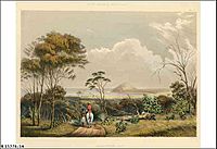
Painting of Encounter Bay by George French Angas from around 1846, showing Rosetta Head from the east.
-
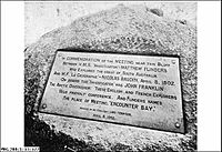
Plaque unveiled on April 8, 1902, celebrating the meeting of Matthew Flinders and Nicolas Baudin in 1802.
-
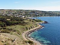
View of Victor Harbor from Rosetta Head.
-
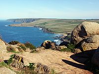
View of the coastline west of Rosetta Head.
-
View of Rosetta Head from the north.
.jpg)
.jpg)


