Russell County, Alabama facts for kids
Quick facts for kids
Russell County
|
||
|---|---|---|

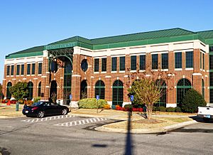
County courthouse in Phenix City
|
||
|
||

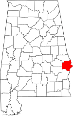
Location within the U.S. state of Alabama
|
||
 Alabama's location within the U.S. |
||
| Country | ||
| State | ||
| Founded | December 18, 1832 | |
| Named for | Gilbert C. Russell | |
| Seat | Phenix City | |
| Largest city | Phenix City | |
| Area | ||
| • Total | 647 sq mi (1,680 km2) | |
| • Land | 641 sq mi (1,660 km2) | |
| • Water | 6.1 sq mi (16 km2) 0.9% | |
| Population
(2020)
|
||
| • Total | 59,183 | |
| • Estimate
(2023)
|
58,744 |
|
| • Density | 91.47/sq mi (35.318/km2) | |
| Time zone | UTC−6 (Central) | |
| • Summer (DST) | UTC−5 (CDT) | |
| Congressional district | 3rd | |
|
||
Russell County is a county located in the southeastern part of Alabama, a U.S. state. In 2020, about 59,183 people lived there. The main city and county seat is Phenix City.
The county is named after Colonel Gilbert C. Russell. He was a military leader who took part in conflicts against the Creek Native Americans.
Russell County is part of the larger Columbus, GA-AL Metropolitan Statistical Area. This means it is connected to the economy and community of Columbus, Georgia.
It's interesting to know that Russell County has a unique feature. More than half of its residents, about 54%, work in a different state. Most of these people work in Columbus, Georgia.
Contents
History of Russell County
Russell County was officially created on December 18, 1832. This happened through a decision by the state's general assembly. The land for the county was once part of the territory of the Creek Native Americans.
Over the years, the county seat, which is the main administrative town, has changed several times. It was first Girard from 1833 to 1839. Then it moved to Crawford (originally called Crockettsville) from 1839 to 1868. After that, Seale was the county seat from 1868 to 1935. Finally, Phenix City became the county seat in 1935 and remains so today.
The county was named after Colonel Gilbert Christian Russell, Sr. He was a brave soldier who fought in the War of 1812. He was born in 1782 and passed away in 1861.
Geography and Location
Russell County covers a total area of about 647 square miles. Most of this area, about 641 square miles, is land. The remaining 6.1 square miles, which is about 0.9% of the total, is water.
Main Roads in Russell County
Many important roads pass through Russell County. These highways help people travel and transport goods across the area.
Neighboring Counties
Russell County shares its borders with several other counties. Some of these are in Alabama, and others are in Georgia.
- Lee County (to the north)
- Muscogee County, Georgia (to the northeast, on the Eastern Time border)
- Chattahoochee County, Georgia (to the east, on the Eastern Time border)
- Stewart County, Georgia (to the southeast, on the Eastern Time border)
- Barbour County (to the south)
- Bullock County (to the southwest)
- Macon County (to the northwest)
Protected Natural Areas
Part of the Eufaula National Wildlife Refuge is located within Russell County. This refuge helps protect wildlife and their natural homes.
Population and People
The number of people living in Russell County has changed over time. Here's a look at the population counts from different years:
| Historical population | |||
|---|---|---|---|
| Census | Pop. | %± | |
| 1840 | 13,513 | — | |
| 1850 | 19,548 | 44.7% | |
| 1860 | 26,592 | 36.0% | |
| 1870 | 21,636 | −18.6% | |
| 1880 | 24,837 | 14.8% | |
| 1890 | 24,093 | −3.0% | |
| 1900 | 27,083 | 12.4% | |
| 1910 | 25,937 | −4.2% | |
| 1920 | 27,448 | 5.8% | |
| 1930 | 27,377 | −0.3% | |
| 1940 | 35,775 | 30.7% | |
| 1950 | 40,364 | 12.8% | |
| 1960 | 46,351 | 14.8% | |
| 1970 | 45,394 | −2.1% | |
| 1980 | 47,356 | 4.3% | |
| 1990 | 46,860 | −1.0% | |
| 2000 | 49,756 | 6.2% | |
| 2010 | 52,947 | 6.4% | |
| 2020 | 59,183 | 11.8% | |
| 2023 (est.) | 58,744 | 10.9% | |
| U.S. Decennial Census 1790–1960 1900–1990 1990–2000 2010–2020 |
|||
What the 2020 Census Shows
The 2020 United States census counted 59,183 people living in Russell County. There were 23,262 households and 14,948 families.
Here's a breakdown of the different groups of people living in Russell County in 2020:
| Race | Number of People | Percentage |
|---|---|---|
| White (not Hispanic) | 26,679 | 45.08% |
| Black or African American (not Hispanic) | 25,930 | 43.81% |
| Native American | 180 | 0.3% |
| Asian | 408 | 0.69% |
| Pacific Islander | 128 | 0.22% |
| Other/Mixed Race | 2,663 | 4.5% |
| Hispanic or Latino | 3,195 | 5.4% |
What the 2010 Census Showed
In the 2010 United States census, there were 52,947 people in the county.
- About 53.7% were White.
- About 41.8% were Black or African American.
- About 0.4% were Asian.
- About 0.4% were Native American.
- About 0.2% were Pacific Islander.
- About 1.3% were from some other race.
- About 2.1% were of two or more races.
- About 3.7% of the total population identified as Hispanic or Latino.
Towns and Communities
Russell County has one main city, one town, and several smaller communities.
City
- Phenix City (This is the county seat. Part of it is also in Lee County.)
Town
Census-designated place
Unincorporated Communities
These are smaller communities that are not officially organized as cities or towns.
Former City
- Girard (This city merged with Phenix City in 1923.)
Notable Person
- James Abercrombie was a United States Congressman from Alabama. He lived in Russell County.
Images for kids
See also
 In Spanish: Condado de Russell (Alabama) para niños


