Sacul, El Petén facts for kids

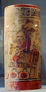
Late Classic vase from Sacul, on display in the Museo Regional del Sureste de Petén in Dolores
|
|
| Location | Dolores |
|---|---|
| Region | Petén Department, Guatemala |
| History | |
| Abandoned | Postclassic Period |
| Periods | Classic Period |
| Cultures | Maya civilization |
| Site notes | |
| Archaeologists | Juan Pedro Laporte |
| Architecture | |
| Architectural styles | Classic Maya |
Sacul is an ancient city built by the Maya civilization in what is now Guatemala. It's an important archaeological site located near the Mopan River in the Petén Department. Sacul was a key city because it sat on a major trade route through the Maya Mountains.
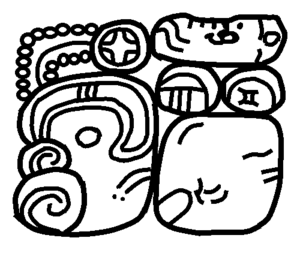
The city was most active during the Late Classic Period, which was from about AD 600 to 900. During the late 700s and early 800s, Sacul was one of the few Maya kingdoms in its region that had its own special symbol, called an Emblem Glyph. This symbol was like a unique flag for the city, showing its power and importance. Other cities with their own Emblem Glyphs included Ixtutz and Ucanal.
In AD 779, Sacul fought a war against a city called Ixkun and lost. However, just 11 years later, the king of Sacul, Ch'iyel, visited Ixkun. Stone monuments, called stelae, at both cities tell us about this visit. It seems the two cities then formed a military alliance, meaning they became friends and worked together.
The center of Sacul has many open areas, called plazas. One of these plazas forms a large, important area known as a monumental acropolis. The plazas were rebuilt and covered with new surfaces during the Terminal Classic period (around AD 800-900). At this time, many people lived in Sacul, and there was a lot of new construction. Buildings were made bigger or changed. Sacul continued to be inhabited into the Postclassic Period, but with fewer people. We don't know if these later residents were direct descendants of the Classic Period Maya. During this final phase, people lived in both the city's main ceremonial area and in the surrounding neighborhoods. Pottery found there shows that Sacul traded with areas like the Belize Valley.
The main part of the city includes large pyramids, a ballcourt for playing games, and special groups of buildings called a triadic complex and E-Group astronomical complexes. These E-Groups were used to track the movements of the sun and stars.
Contents
Sacul's Location
The Sacul Valley is in the northern part of the Maya Mountains. It's only about 10 miles (16 km) from the border with Belize. The land here is hilly, with heights ranging from about 1,476 to 2,132 feet (450 to 650 meters) above sea level.
The Sacul River flows north and is part of the larger Mopan River system. The Sacul River joins the Mopan and Xaan Rivers, then flows into Belize where it becomes the Belize River. Finally, it empties into the Caribbean Sea.
The area has north-south limestone ridges. Along the river banks, there's a narrow flat area, or flood plain, which is never wider than about 0.6 miles (1 km). This plain is surrounded by tall cliffs. The mountain tops around Sacul are covered with thick rainforest. However, the lower slopes have been cleared for farming, especially for milpa (a traditional farming system) and raising cattle.
Sacul was built on a natural pathway through the mountains. From Sacul, ancient routes led about 17 miles (28 km) south to Poptún. Other paths went west to Xaan (about 3 miles or 5 km) and Ixtonton (about 7 miles or 12 km). To the north, a route led to Ucanal (about 22 miles or 36 km). There were also paths northwest to El Chal and northeast to Caracol.
Sacul's History
Important Rulers
The most powerful known ruler of Sacul was King Ch'iyel. He ruled from around 760 AD to at least 790 AD. Ch'iyel was involved in many important events, including wars, special ceremonies, and visits from other kings. He was likely the ruler who oversaw the most building projects in the city.
| Ruler's Name | When They Ruled |
|---|---|
| Ch'iyel | Around 760–790+ AD |
The Late Classic Period
Between AD 760 and 820, cities in the northern Maya Mountains began to create their own carved stone monuments. This shows a big change in how power was shared. New powerful cities like Sacul, Ixkun, Ixtutz, and Ixtonton became very important. Out of these, only Sacul and Ixtutz had their own special Emblem Glyphs.
King Ch'iyel of Sacul was a very active ruler. On February 12, 760 AD, he received a visit from King Shield Jaguar II of Ucanal. This visit was to mark Ch'iyel officially becoming a ruler, symbolized by him receiving a special "mannequin sceptre."
During the Late Classic period, Sacul was part of a large trading network. It also made its own pottery. A stone monument called Stela 2 at Ixkun tells us about a battle between Sacul and Ixkun on December 21, 779 AD. Sacul seems to have lost this battle. Ixkun fought another battle against Ucanal a few months later. This might mean Ucanal was helping its ally, Sacul, but Ixkun still won.
However, the fighting between Sacul and Ixkun didn't last long. On October 11, 790 AD, King Ch'iyel of Sacul visited Ixkun. This visit is recorded on stelae at both cities. The monuments show the two kings together, suggesting they formed a military alliance. They might have teamed up against another city, possibly Ixtonton. Their goal might have been to capture people for sacrifice. After this expedition, both kings celebrated a k'atun-ending ceremony (a special event every 20 years) and took part in a bloodletting ritual.
The Terminal Classic Period
In the Terminal Classic period (around AD 800-900), the southeastern Petén region saw big changes in its political landscape. Sacul's power grew, and it took over nearby centers like Caxeba and El Mozote. These cities were then abandoned as Sacul became stronger.
At the same time, trade patterns changed. People started using more pottery made locally in the Maya Mountains, and there was less trade with distant regions.
By 820 AD, many cities in the Dolores region became quiet and were abandoned. This was part of the Classic Maya collapse. The last stone monument put up in Sacul dates to AD 800. While many cities were abandoned, Sacul survived longer than its rivals and allies. It continued into the Postclassic Period, once again becoming part of the regional trade network.
Sacul's Layout
The Sacul site is divided into five main areas, all part of the same ancient city. These are called Sacul 1 through Sacul 5. Sacul 1 is the main part of the city from the Late Classic period. The presence of a triadic complex in Plaza C shows that Sacul was connected to the wider Maya world. This type of building style started in the central Maya lowlands a long time ago.
The main part of Sacul is built on a natural hill about 130 feet (40 meters) high. This hill was flattened by the Maya to create two large terraces.
Group A
Group A (also known as the West Group) is on the lower terrace. It has three main building areas. Many carved stone monuments from the Late Classic period were found here. A burial from the Terminal Classic period was found carved into the bedrock under the plaza. It was covered with limestone slabs. Inside the burial were ten ceramic pots, including an incense burner, plates, and bowls.
The Ballcourt is in Plaza B. It's lined up north-south, and the playing area is about 56 feet (17 meters) long and 13 feet (4 meters) wide. It had sloped sides and open ends, which was common for ballcourts in this region. The side walls were about 11 feet (3.4 meters) high.
Plaza C is north of Group A. It was built on a platform about 39 feet (12 meters) high, overlooking Group A. This platform measured about 223 by 197 feet (68 by 60 meters). You could reach it by a stairway on the southwest side. It was first built during the Late Classic period and was changed many times until the Terminal Classic. Twelve buildings were on this platform, including pyramids. The plaza also has three structures that form a clear example of a triadic architectural complex. Two plain stone monuments were found in Group C.
The East Structure of Plaza C had two plain round altars found during digging. These altars might have been moved from other parts of the city. This structure had several levels. In the Terminal Classic, a small burial chamber, called a cist, was placed in the upper level and covered with limestone slabs. An offering was placed on top of it, including an obsidian blade and eleven ceramic pots. Inside the cist were the remains of a teenager, along with many valuable items. These included two ceramic pots, an alabaster vase, and various ornaments, rings, and beads made from snail shells, mother-of-pearl, greenstone, and pyrite.
Group B
Group B (also known as the East Group) is on the upper terrace. You could get to it from Group A by a long, raised pathway called a causeway. This causeway was about 426 feet (130 meters) long and 46 feet (14 meters) wide, with low walls on its sides. Group B has nine buildings on one large platform, arranged around two plazas, D and E.
Plaza D has a large traditional E-Group astronomical complex. This complex might have been more important for ceremonies than a similar one in Group A. The plaza covers an area of about 12,917 square feet (1200 square meters).
The E-Group west pyramid is about 24 feet (7.4 meters) high. The east platform is lower, which is common in Maya E-Groups, though it's unusual for this specific region. It stands about 13 feet (4 meters) high.
Plaza E (also called the Northeast Plaza) has a north structure that looks similar to the east platforms of E-Group complexes. It has a small temple on the central part of a longer platform. This is the only example of this type of building in the Dolores region that isn't part of a formal astronomical complex.
The North Structure of Plaza E contained a large collection of Terminal Classic pottery. This included hundreds of simple plates and many incense burners. The plates were tied together with vines, suggesting they were likely placed there by traders.
Sacul's Monuments
Archaeologists found many stone monuments at Sacul. These include six carved monuments, five plain stone slabs called stelae, and seven plain altars in the West Group. Two rows of stelae were set up in front of the East Platform of Plaza A. Besides these numbered monuments, other unnumbered pieces were found around the site, especially near the ballcourt.
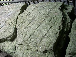
Stela 1 was moved to the West Plaza during archaeological work. King Ch'iyel dedicated it on March 17, 761 AD. It also has an earlier date, February 12, 760 AD. The carvings on it describe Ch'iyel taking part in a bloodletting ceremony. Stela 1 is the oldest dated monument found at Sacul. It was made from a type of stone called slate and was found broken into four pieces. The top part with hieroglyphs was cut away by looters.
Stela 2 was set up to remember King Ch'iyel's visit to Ixkun on October 11, 790 AD. It shows portraits of both the king of Sacul and the king of Ixkun. This monument was found lying down in Plaza A of the West Group, near an altar. It looks very similar to Stela 1 from Ixkun. It shows the two rulers facing each other, holding staffs that represent their power. A prisoner is shown in a panel below their feet. Stela 2 was made from limestone, is broken in two parts, and is very worn down.
Stela 3 was found lying down in Plaza A of the West Group, west of Stela 2, and was associated with an altar. It is very worn, but it had three carved sections, called cartouches, with hieroglyphic writing. Even though most of it is hard to read now, it clearly included several dates from the Maya calendar.
Stela 6 is in the front row of stelae at the base of the East Platform. The main part of the stela has broken and fallen forward, but its base is still in place. Stela 6 was found with Altar 4. It was carved with a royal figure and a hieroglyphic text that included a Maya calendrical date. The text is very worn, so the full date is incomplete, but the day "1 Muluc 8 Zip" is still readable. Experts believe this monument was made around the early 800s AD, because it looks similar to Stela 11 from Naranjo.
Stela 9 is a carved monument in Plaza A of the West Group. It was dedicated on October 11, 790 AD, and shows the carved figure of King Ch'iyel. This stela was originally placed at the start of the causeway leading to the East Group, but it was moved in the late 1900s.
Stela 10 was dedicated in AD 800 and might be the last monument ever put up in Sacul. It was found fallen at the base of Structure 7 in the northwest part of Plaza A, near a plain altar, Altar 5. The date on it seems to be August 19, 800 AD.
Images for kids
See also
 In Spanish: Sacul para niños
 | Precious Adams |
 | Lauren Anderson |
 | Janet Collins |


