St. Croix Falls, Wisconsin facts for kids
Quick facts for kids
St. Croix Falls, Wisconsin
|
|
|---|---|
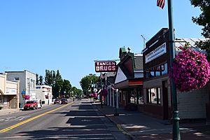
Downtown St. Croix Falls, 2018
|
|
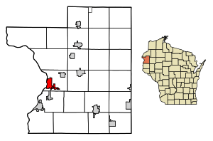
Location of St. Croix Falls in Polk County, Wisconsin.
|
|
| Country | United States |
| State | Wisconsin |
| County | Polk |
| Area | |
| • Total | 5.12 sq mi (13.25 km2) |
| • Land | 4.98 sq mi (12.91 km2) |
| • Water | 0.13 sq mi (0.34 km2) |
| Population
(2020)
|
|
| • Total | 2,208 |
| • Density | 442.8/sq mi (171.0/km2) |
| Time zone | UTC-6 (Central (CST)) |
| • Summer (DST) | UTC-5 (CDT) |
| ZIP codes |
54024
|
| Area code(s) | 715 & 534 |
| FIPS code | 55-70550 |
St. Croix Falls is a city in Polk County, Wisconsin, United States. It's located right next to the St. Croix River, which is where it gets its name. In 2020, about 2,208 people lived here. You can reach St. Croix Falls using major roads like U.S. Route 8, Wisconsin Highway 35, and Wisconsin Highway 87.
Contents
History of St. Croix Falls
In the 1840s, people from places like Scandinavia and Germany started to settle the land that would become St. Croix Falls. The area grew a lot because of the logging industry. In 1887, St. Croix Falls officially became an "incorporated" town, meaning it had its own local government.
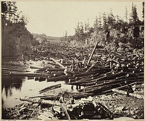
Logging was very important here. Many people from New England moved to the area to cut down huge amounts of white pine trees. These logs were then sent down the St. Croix River and the Mississippi River. By the late 1890s, the logging business started to slow down. The very last log was cut at the local mill in 1914. After that, St. Croix Falls became more of a farming town.
In 1907, the Saint Croix Falls Dam was built on the river. This dam helps create hydroelectricity, which is power made from moving water, for the city of Minneapolis. St. Croix Falls officially became a city in 1958.
Geography of St. Croix Falls
St. Croix Falls is located at 45°24′43″N 92°38′20″W / 45.41194°N 92.63889°W. The city covers about 4.78 square miles (12.38 square kilometers). Most of this area is land, with a small part being water.
The city is right across the St. Croix River from Taylors Falls, Minnesota.
Population and People
| Historical population | |||
|---|---|---|---|
| Census | Pop. | %± | |
| 1870 | 288 | — | |
| 1880 | 216 | −25.0% | |
| 1890 | 745 | 244.9% | |
| 1900 | 622 | −16.5% | |
| 1910 | 569 | −8.5% | |
| 1920 | 825 | 45.0% | |
| 1930 | 952 | 15.4% | |
| 1940 | 1,007 | 5.8% | |
| 1950 | 1,065 | 5.8% | |
| 1960 | 1,249 | 17.3% | |
| 1970 | 1,425 | 14.1% | |
| 1980 | 1,497 | 5.1% | |
| 1990 | 1,640 | 9.6% | |
| 2000 | 2,033 | 24.0% | |
| 2010 | 2,133 | 4.9% | |
| 2020 | 2,208 | 3.5% | |
| U.S. Decennial Census | |||
2020 Census Information
In 2020, the population of St. Croix Falls was 2,208 people. Most residents, about 93.5%, were White. There were also smaller groups of Asian, Black or African American, and Native American people. About 3.9% of the population identified as being from two or more races. About 1.9% of the people were of Hispanic or Latino background.
2010 Census Information
Back in 2010, there were 2,133 people living in St. Croix Falls. About 96.7% of the people were White. Other groups included African American, Native American, and Asian residents. About 1.8% of the population was Hispanic or Latino.
There were 967 households in the city. About 26% of these households had children under 18 living there. The average age of people in the city was 44.3 years old. About 22.1% of residents were under 18, and 21.8% were 65 or older.
Fun Things to Do and See
St. Croix Falls hosts a four-day event called Wannigan Days. This festival is held in both St. Croix Falls and Taylors Falls, Minnesota. It celebrates the history of logging in the St. Croix River area.
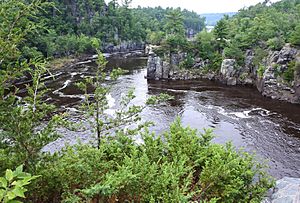
The city is also home to the headquarters for the St. Croix National Scenic Riverway. This is a special area that protects the river. St. Croix Falls is also right next to Interstate Park, which is a state park in both Minnesota and Wisconsin. This park is famous for the Dalles of the St. Croix River, which are amazing rock formations.
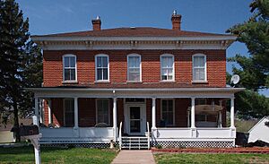
If you like trails, St. Croix Falls is the starting point for both the Ice Age Trail and the Gandy Dancer State Trail. You can also find historic buildings here, like the Cushing Land Agency Building, the Lamar Community Center, and the Thomas Henry Thompson House.
Schools in St. Croix Falls
The local schools are part of the St. Croix Falls School District. Students attend St. Croix Falls High School for their high school education.
Famous People from St. Croix Falls
- Vernon A. Forbes, who was a representative in Oregon.
- Donald L. Iverson, who was a representative in Wisconsin.
- Megan Kalmoe, a U.S. Olympian.
- William R. Marshall, who was the Governor of Minnesota.
- James Henry McCourt, who was a representative in Wisconsin.
- John Morgan, a Vice Admiral in the U.S. Navy.
- Roy Patterson, a Major League Baseball player for the Chicago White Sox.
- James Breck Perkins, an author and United States Congressman.
See also
 In Spanish: St. Croix Falls (Wisconsin) para niños


