
Sakaiminato, Tottori facts for kids
Quick facts for kids
Sakaiminato
境港市
|
|||||||||||
|---|---|---|---|---|---|---|---|---|---|---|---|

Downtown Sakaiminato, near Sakaiminato Station
|
|||||||||||
|
|||||||||||

Location of Sakaiminato in Tottori Prefecture
|
|||||||||||

Sakaiminato
Location in Japan
|
|||||||||||
| Country | Japan | ||||||||||
| Region | Chūgoku (San'in) | ||||||||||
| Prefecture | Tottori | ||||||||||
| Area | |||||||||||
| • Total | 29.10 km2 (11.24 sq mi) | ||||||||||
| Population
(1 June 2016)
|
|||||||||||
| • Total | 32,012 | ||||||||||
| • Density | 1,100.07/km2 (2,849.2/sq mi) | ||||||||||
| Time zone | UTC+09:00 (JST) | ||||||||||
| City hall address | 3000, Agarimichichō, Sakaiminato-shi, Tottori-ken 684-8501 | ||||||||||
| Climate | Cfa | ||||||||||
|
|||||||||||


Sakaiminato (境港市 (Sakaiminato-shi)) is a city in Tottori Prefecture, Japan. As of December 31, 2021, about 32,012 people lived there. They lived in 13,178 homes.
The city has a population density of 1,110 people per square kilometer. The total area of Sakaiminato is 272.06 square kilometers.
Contents
Where is Sakaiminato?
Sakaiminato is in the far western part of Tottori Prefecture. It sits at the northern end of the Yumigahama Peninsula.
The city is surrounded by water on three sides. These waters include Lake Nakaumi, the Sea of Japan, and the Sakai Channel. The Sakai Channel connects the lake and the sea.
Across the Sakai Channel, or by crossing the Eshima Ohashi Bridge, you can reach the city of Matsue in Shimane Prefecture. Sakaiminato is built on a sandbar. This means the land is very flat. Its average height is only two meters above sea level.
Nearby Cities
What is the Climate Like?
Sakaiminato has a humid climate. This means it has warm, wet summers. Winters are cold and often have heavy snowfall.
The average yearly temperature in Sakaiminato is 15.5 degrees Celsius. The city gets about 1903.3 millimeters of rain each year. July is usually the wettest month.
Temperatures are highest in August, around 27.3 degrees Celsius. They are lowest in January, around 4.9 degrees Celsius. The hottest day ever recorded was 38.5 degrees Celsius on August 22, 2018. The coldest day was -9.7 degrees Celsius on January 27, 1904.
| Climate data for Sakaiminato (1991−2020 normals, extremes 1883−present) | |||||||||||||
|---|---|---|---|---|---|---|---|---|---|---|---|---|---|
| Month | Jan | Feb | Mar | Apr | May | Jun | Jul | Aug | Sep | Oct | Nov | Dec | Year |
| Record high °C (°F) | 19.7 (67.5) |
24.6 (76.3) |
26.7 (80.1) |
31.2 (88.2) |
32.9 (91.2) |
35.0 (95.0) |
37.5 (99.5) |
38.5 (101.3) |
36.9 (98.4) |
33.6 (92.5) |
27.7 (81.9) |
22.3 (72.1) |
38.5 (101.3) |
| Mean daily maximum °C (°F) | 8.3 (46.9) |
9.2 (48.6) |
12.8 (55.0) |
18.4 (65.1) |
23.1 (73.6) |
26.0 (78.8) |
29.9 (85.8) |
31.5 (88.7) |
27.0 (80.6) |
22.1 (71.8) |
16.7 (62.1) |
11.0 (51.8) |
19.7 (67.4) |
| Daily mean °C (°F) | 4.9 (40.8) |
5.3 (41.5) |
8.3 (46.9) |
13.3 (55.9) |
18.1 (64.6) |
21.8 (71.2) |
25.9 (78.6) |
27.3 (81.1) |
23.2 (73.8) |
17.8 (64.0) |
12.4 (54.3) |
7.3 (45.1) |
15.5 (59.8) |
| Mean daily minimum °C (°F) | 1.7 (35.1) |
1.6 (34.9) |
3.9 (39.0) |
8.4 (47.1) |
13.6 (56.5) |
18.4 (65.1) |
22.9 (73.2) |
24.1 (75.4) |
20.0 (68.0) |
13.8 (56.8) |
8.4 (47.1) |
3.9 (39.0) |
11.7 (53.1) |
| Record low °C (°F) | −9.7 (14.5) |
−8.2 (17.2) |
−5.6 (21.9) |
−2.1 (28.2) |
1.8 (35.2) |
7.0 (44.6) |
12.0 (53.6) |
14.5 (58.1) |
8.3 (46.9) |
2.3 (36.1) |
−1.4 (29.5) |
−7.9 (17.8) |
−9.7 (14.5) |
| Average precipitation mm (inches) | 188.4 (7.42) |
136.0 (5.35) |
139.7 (5.50) |
111.2 (4.38) |
123.3 (4.85) |
170.8 (6.72) |
215.2 (8.47) |
140.9 (5.55) |
212.8 (8.38) |
133.5 (5.26) |
145.9 (5.74) |
193.2 (7.61) |
1,903.3 (74.93) |
| Average snowfall cm (inches) | 32 (13) |
25 (9.8) |
6 (2.4) |
0 (0) |
0 (0) |
0 (0) |
0 (0) |
0 (0) |
0 (0) |
0 (0) |
0 (0) |
14 (5.5) |
75 (30) |
| Average precipitation days (≥ 1.0 mm) | 19.6 | 15.0 | 13.2 | 10.4 | 9.1 | 9.9 | 11.0 | 9.4 | 10.8 | 10.1 | 13.0 | 18.5 | 150 |
| Average snowy days (≥ 1 cm) | 7.1 | 5.8 | 1.1 | 0 | 0 | 0 | 0 | 0 | 0 | 0 | 0 | 3.4 | 17.4 |
| Average relative humidity (%) | 74 | 72 | 69 | 68 | 70 | 77 | 79 | 76 | 77 | 74 | 73 | 74 | 74 |
| Mean monthly sunshine hours | 63.0 | 81.8 | 137.9 | 183.9 | 208.9 | 162.0 | 174.3 | 207.1 | 147.5 | 154.8 | 109.2 | 74.7 | 1,705.1 |
| Source: Japan Meteorological Agency | |||||||||||||
How Many People Live Here?
The population of Sakaiminato has changed over the years. Here is how it has grown and shrunk, based on Japanese census data:
| Historical population | ||
|---|---|---|
| Year | Pop. | ±% |
| 1920 | 21,199 | — |
| 1930 | 24,267 | +14.5% |
| 1940 | 22,386 | −7.8% |
| 1950 | 29,746 | +32.9% |
| 1960 | 32,714 | +10.0% |
| 1970 | 34,145 | +4.4% |
| 1980 | 38,278 | +12.1% |
| 1990 | 37,282 | −2.6% |
| 2000 | 36,843 | −1.2% |
| 2010 | 35,219 | −4.4% |
What Does the Name Sakaiminato Mean?
The name Sakaiminato comes from two kanji characters in Japanese.
So, Sakaiminato means "border port."
A Look at Sakaiminato's History
The area where Sakaiminato is located has a very long history. People lived here during the Yayoi period and Kofun period. We know this because old remains from these times have been found in the city.
During the Muromachi period, a powerful family called the Amago clan controlled this area. Sakaiminato was an important place for shipping rice. It was also a safe harbor for navy ships.
Later, in the Sengoku period, the Mōri clan took control. During the Edo Period, the Ikeda clan of Tottori Domain owned the land.
After the Meiji restoration, the port became very busy. It was a key stop for ships traveling along the Sea of Japan. In 1896, it became a trading port. Ships from Sakaiminato traded with cities like Busan, Incheon, and Wonsan on the Korean Peninsula.
The town of Sakai was officially created on October 21, 1889. It became a city on April 1, 1956. At that time, its name was changed to Sakaiminato.
Sakaiminato's Economy

The seaport of Sakaiminato has been important for a long time. It serves the San'in Region of Japan.
After World War II, the city became a major center for fishing. It is now a base for the fishing industry in all of Western Japan. Because of this, making products from seafood is also a big business in the city.
Schools in Sakaiminato
Sakaiminato has several schools for children.
- There are six public elementary schools.
- There are three public junior high schools.
These schools are run by the city government.
The city also has two public high schools. These are managed by the Tottori Prefectural Board of Education.
Getting Around Sakaiminato
Airports
- Miho-Yonago Airport
Trains
![]() JR West operates the Sakai Line.
JR West operates the Sakai Line.
- The train stops are: Yonago Airport - Nakahama - Takamatsuchō - Amariko - Agarimichi - Babasakichō - Sakaiminato
Main Roads
 National Route 431
Seaports
- Port of Sakaiminato: This port is home to the DBS Cruise ferry Eastern Dream. This ferry connects Japan to Donghae, South Korea, and Vladivostok, Russia.
Sister Cities
Sakaiminato has a special friendship with another city. This is called being "twinned".
 Hunchun, China
Past Sister Cities
 Wonsan, North Korea (this agreement ended in 2006).
Sakaiminato was the only Japanese city to have a sister city agreement with a city in North Korea. This agreement lasted from 1992 to 2006. In 2006, the mayor, Katsuji Nakamura, ended the agreement. This happened after North Korea announced a nuclear test. The Japanese government also decided to place economic restrictions. The sister city activities had already mostly stopped by 2002. After that, the cities only sent each other a letter once a year.
Fun Places to Visit
- Tottori Domain Battery Sites, which is a National Historic Site.
Famous People from Sakaiminato
- Shigeru Mizuki was the creator of GeGeGe no Kitaro. This is a very popular character seen all over Japan. Even though he was born in Osaka, Mizuki grew up in Sakaiminato. You can find the spirit of Kitaro in Sakaiminato on Kitaro Road. This street is dedicated to all the characters from Mizuki's stories. More than one hundred bronze statues of the characters line both sides of the road.
- Shōji Ueda
Images for kids
-
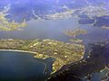
Aerial view of part of Sakaiminato.
-
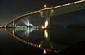
Eshima Ohashi Bridge links Sakaiminato and Matsue across a narrow channel.

.jpg)
See also
 In Spanish: Sakaiminato (Tottori) para niños
