Salado River (Argentina) facts for kids

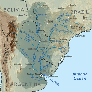
The Salado River is a long river in Argentina. Its name, Río Salado, means "Salty River" in Spanish. This river flows for about 1,150 kilometers (715 miles) across several parts of Argentina. It starts in the Salta Province and ends by joining the Paraná River in the Santa Fe Province.
The amount of water in the Salado River changes a lot during the year. Sometimes, parts of it can even dry up in winter. The most important river that flows into the Salado is the Horcones River. It begins in Salta as the Cajón River and joins the Salado in the Santiago del Estero Province.
Contents
Where the Salado River Begins
The Salado River starts high up in the Andes mountains. It begins on the eastern side of the Altiplano, a high plateau. Here, it is called the Juramento River. Its water comes from melting snow and rain from tall mountains like Acay and Cachi, which are about 6,500 meters (21,300 feet) high. These mountains are in the Salta Province, close to the Catamarca Province.
A large structure called the Cabra Corral Dam helps control how much water flows in the river. It also sends some water to help farmers grow crops through irrigation.
As the river leaves the mountains and enters the flat Gran Chaco plains, it spreads out. It forms many smaller streams and channels within a wide riverbed. However, only part of this wide area is filled with water.
The Salado River in Santiago del Estero
The river then flows into the Santiago del Estero Province from the north. When it enters this province, it officially gets the name Salado. The Salado River and the Dulce River ("Sweet River"), which is to its south, both flow diagonally towards the southeast.
These two rivers are very important for the dry lands of Santiago del Estero. They provide water and are central to the economy and where people live in the province.
The water flow of the Salado River is managed by the Los Figueroa Reservoir. There is also a special dam called a Derivation Dam (Dique Derivador). This dam redirects some of the river's water into long canals, which can be up to 200 kilometers (124 miles) long. These canals are used for irrigation.
Further downstream, the river creates large, wet areas called marsh wetlands. These areas often flood during the summer when there is a lot of rain and the water levels are high. After the Añatuya marshlands, the river's flow becomes much smaller. Because of this, the river can be dry for most of the year in these parts.
The Salado River's Journey to the Paraná
After flowing for about 800 kilometers (497 miles) through Santiago del Estero, the river reaches the Santa Fe Province. Here, it is sometimes called Salado del Norte, meaning "Northern Salty River." It finally joins the Paraná River in Santa Fe. The Salado is the last major tributary that flows into the Paraná River.
In Santa Fe Province, there is more rainfall. This extra rain causes the Salado River to have more water. During rainy summers, the river can sometimes overflow its banks. This can lead to floods. For example, a flood in 2003 greatly affected the city of Santa Fe.
The Salado River flows into the Paraná River southeast of Santa Fe City. This area is often flooded and has many lagoons.
Other Rivers Named Salado in Argentina
There are a few other rivers in Argentina that are also called Salado, but they are not as big or important as the one we just learned about. Here are a couple of them:
- In Buenos Aires Province, a different Río Salado starts at the El Chañar lagoon. It flows southeast for about 650 kilometers (404 miles) to the Samborombón Bay.
- In Mendoza Province, San Luis Province, and La Pampa Province, there is a river system called the Desaguadero-Salado. This river flows down to the Colorado River.
See also
 | Chris Smalls |
 | Fred Hampton |
 | Ralph Abernathy |

