Salt River (Wyoming) facts for kids
Quick facts for kids Salt River |
|
|---|---|

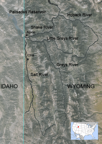
Map of Salt, Greys and Hoback River showing the Salt
|
|
| Country | United States |
| State | Wyoming |
| Physical characteristics | |
| Main source | Mount Wagner, Salt River Range, Wyoming 42°35′38″N 110°48′08″W / 42.59389°N 110.80222°W |
| River mouth | Palisades Reservoir Alpine, Wyoming 43°10′02″N 111°03′52″W / 43.16722°N 111.06444°W |
| Length | 84 mi (135 km) |
| Basin features | |
| Basin size | 890 sq mi (2,300 km2) |
The Salt River is a river in western Wyoming. It is about 84 miles (135 km) long. It flows through Lincoln County.
The river gets its name from salty areas and springs nearby. These springs have very pure salt. Some of this salty water flows into the Salt River through Stump Creek.
Long ago, Native American tribes and pioneers visited the Salt River valley. They came to find salt and hunt animals. The river starts high up near Mount Wagner in the Salt River Range.
It flows west from the mountains. Then it turns north, following the border between Wyoming and Idaho. The river flows past towns like Smoot, Wyoming. It winds through the farming area known as Star Valley. Many smaller creeks join the Salt River along the way. Finally, it meets the Snake River near the town of Alpine.
Contents
About the Salt River's Journey
The Salt River collects water from about 890 square miles (2,300 km²) of land. This area includes the western part of the Salt River Range in Wyoming. It also includes the eastern part of the Caribou Range in Idaho.
The Greys River is another river that flows into the Snake River. It joins the Snake River just a few miles east of where the Salt River does.
The Narrows and Palisades Reservoir
About halfway along its path, the Salt River flows through a section called "the Narrows." Here, the river cuts between two ridges. These ridges divide Star Valley into an upper and lower part.
The end of the Salt River now flows into the Palisades Reservoir. This happens especially when water levels are high. The reservoir is located in Idaho.
Traveling Along the River
Wyoming Highway 89 runs right next to the Salt River. This highway goes north towards famous places. These include Grand Teton and Yellowstone National Park.
Fishing in the Salt River
The Salt River is a great place for fly fishing. You can catch several types of trout here. These include brook trout, rainbow trout, cutthroat trout, and brown trout.
The state of Wyoming considers the Salt River a "Class 2 (red)" fishing spot. This means it has very good trout waters. These fisheries are important for the whole state.
A Look Back: Salt River History
Before about 1890, the Salt River valley was a popular summer spot. Different Native American tribes visited it often. They valued the many animals and fish, and the salt found there.
From about 1810 to 1840, many trappers came to the river. They trapped beaver, muskrats, and other animals for their fur. They usually did this in the spring and fall.
The Lander Road and Salt Works
From about 1858 to 1910, a famous trail followed the river. This was the Lander Road. It was part of the Oregon and California Trail. It ran alongside much of the river, from above Smoot to Auburn, Wyoming.
Between 1866 and 1880, a large salt business operated here. It was called the Oneida Salt Works. They dried salt from the springs. Then they sold it to miners, ranchers, and others in Wyoming, Idaho, and Montana. They would close down during the winter months.
Before about 1879, people did not stay in the high valley during winter. They would leave for warmer places. Later, this valley became known as Star Valley.
Salt River Tributaries and Towns
Many smaller creeks flow into the Salt River. Some of these are Cottonwood, Stump, Willow, Strawberry, Cedar, Jackknife, and Dry creeks.
Several towns are located near the river as it flows north:
 | Ernest Everett Just |
 | Mary Jackson |
 | Emmett Chappelle |
 | Marie Maynard Daly |

