
San Elizario, Texas facts for kids
Quick facts for kids
San Elizario, Texas
|
|
|---|---|
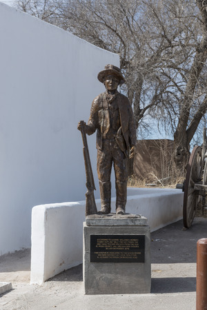
Statue of William Bonney, or "Billy the Kid," in the arts district of little San Elizario, near El Paso, Texas
|
|

Location of San Elizario, Texas
|
|
 |
|
| Country | United States |
| State | Texas |
| County | El Paso |
| Incorporated | November 5, 2013 |
| Government | |
| • Type | Mayor-council |
| Area | |
| • Total | 6.89 sq mi (17.83 km2) |
| • Land | 6.88 sq mi (17.83 km2) |
| • Water | 0.00 sq mi (0.01 km2) |
| Elevation | 3,639 ft (1,109 m) |
| Population
(2020)
|
|
| • Total | 10,116 |
| • Density | 1,468.2/sq mi (567.36/km2) |
| Time zone | UTC-7 (Mountain (MST)) |
| • Summer (DST) | UTC-6 (MDT) |
| ZIP code |
79849
|
| Area code(s) | 915 |
| FIPS code | 48-65360 |
| GNIS feature ID | 2770964 |
San Elizario is a city in El Paso County, Texas, United States. In 2020, about 10,116 people lived there. It is part of the larger El Paso area. The city is located right next to the Rio Grande. This river forms the border between the United States and Mexico. San Elizario is next to the city of Socorro on its west side. The town of Clint is to its north.
Contents
History of San Elizario
San Elizario has a long and interesting history. It started as a small settlement and grew over many years.
The "Taking Possession" of New Mexico
In 1598, a Spanish nobleman named Juan de Oñate led a large group of people. They were colonists and had many animals, like horses and cattle. They traveled from southern Mexico to settle a new area called the province of New Mexico.
After weeks of travel, they reached the Rio Grande river near where San Elizario is today. Oñate held a special ceremony. He officially claimed the new land for the King of Spain. This event is seen as the "Birth of the American Southwest".
Hacienda de los Tiburcios
The area that became San Elizario was first settled before 1760. It was a civilian settlement called Hacienda de los Tiburcios. A hacienda was like a large estate or farm. It was located along an old trade route called Camino Real de Tierra Adentro. This hacienda was later left empty by the 1770s.
Presidio San Elzeario: A Fort for Protection
In 1789, the old hacienda site became a new fort. It was called Presidio de San Elzeario. A presidio was a military fort used by the Spanish. This fort was moved here to better protect the Camino Real. It also protected the nearby towns of Socorro and Ysleta.
The town that grew around the fort took its name from the presidio. "San Elzeario" means Saint Elzear in Spanish. Saint Elzéar of Sabran is known as the patron saint of soldiers. After the Mexican American War, the United States took control of the town. Its name was then changed to the more Americanized "San Elizario."
San Elizario: County Seat and Salt War
San Elizario was once the first county seat for El Paso County. A county seat is the main town where the county government is located.
The Salt War of 1877
In 1877, a conflict called the Salt War happened. It was a fight over who owned the salt lakes nearby. A group of Texas Rangers were involved. They surrendered, and some were harmed by the local people. After this, the people who caused the trouble went to Mexico. The town of San Elizario lost some of its importance because of this event.
Becoming an Official City
San Elizario tried to become an official city many times between 1871 and 1911. Another attempt in 1986 was not successful. Finally, on November 5, 2013, the people of San Elizario voted to become a city again. They had worked hard to prevent the nearby city of Socorro from taking over some of their land.
On November 18, 2013, San Elizario officially became an incorporated city. In May 2014, Maya Sanchez was elected as the mayor. She had led the effort to make San Elizario a city.
Geography of San Elizario
San Elizario covers an area of about 6.89 square miles (17.83 square kilometers). Only a very small part of this area is covered by water.
Population Information
| Historical population | |||
|---|---|---|---|
| Census | Pop. | %± | |
| 1980 | 1,548 | — | |
| 1990 | 4,385 | 183.3% | |
| 2000 | 11,046 | 151.9% | |
| 2010 | 13,603 | 23.1% | |
| 2020 | 10,116 | −25.6% | |
| U.S. Decennial Census | |||
San Elizario first appeared in the U.S. Census in 1980. After it became a city in 2013, it was listed as a city in the 2020 Census.
2020 Census Data
The 2020 United States census showed that 10,116 people lived in San Elizario. There were 2,435 households and 2,168 families in the city.
| Race | Number | Percentage |
|---|---|---|
| White (NH) | 162 | 1.6% |
| Black or African American (NH) | 22 | 0.22% |
| Native American or Alaska Native (NH) | 19 | 0.19% |
| Asian (NH) | 1 | 0.01% |
| Some Other Race (NH) | 18 | 0.18% |
| Mixed/Multi-Racial (NH) | 21 | 0.21% |
| Hispanic or Latino | 9,873 | 97.6% |
| Total | 10,116 |
Education in San Elizario
Students in San Elizario attend schools that are part of the San Elizario Independent School District.
San Elizario Chapel
The San Elizario Chapel is a very old and important building. It was never a mission church. Instead, it was a chapel for a presidio, which was a military outpost. It served the religious needs of the soldiers stationed there.
The presidio was moved to its current spot in 1789. Its job was to protect travelers and settlers along the Camino Real. This "Royal Highway" went from Mexico City all the way to Santa Fe, New Mexico. The chapel also helped protect the nearby Ysleta and Socorro missions.
When Mexico became independent from Spain in 1821, fewer soldiers were at the presidio. By 1848, the presidio was in ruins. People started rebuilding in 1853, first with a small church. The current, larger building was finished in 1882. The outside of the chapel looks almost the same today as it did back then.
A scene from the 1985 movie Fandango was filmed in the plaza of the San Elizario church.
See also
 In Spanish: San Elizario, Texas para niños
