
San Juan de los Morros facts for kids
Quick facts for kids
San Juan de los Morros
|
||
|---|---|---|
|
City
|
||
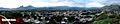
    San Juan de los Morros panoramic view, the San Juan Bautista Statue and the Morros de San Juan
|
||
|
||
.svg)
San Juan de los Morros
Location in Venezuela
|
||
| Country | ||
| State | Guárico | |
| Municipality | Juan Germán Roscio Municipality | |
| Founded | 26 May 1780 | |
| Founded by | Mariano Martí | |
| Elevation | 428.5 m (1,405.8 ft) | |
| Population | ||
| • Total | 120,111 | |
| Demonym(s) | Sanjuanero/a | |
| Time zone | UTC−4 (VET) | |
| postal code |
2301
|
|
| area code | 0246 | |
| Climate | Aw | |
.svg)
San Juan de los Morros is the capital city of Guárico State in Venezuela. People often call it the "Gateway to the Central Plains" (Puerta a Los Llanos Centrales). This city is known for its amazing mountains. About 120,111 people lived here in 2011. It is the second most populated city in Guárico State, after Calabozo. However, it has the most people living per square kilometer.
San Juan de los Morros was one of the first cities founded in Guárico State. Other early cities include Calabozo, Valle de la Pascua, and Zaraza. Important places in the city are the Monument to the Flag and the mountains called Arístides Rojas, also known as Morros de San Juan. There is also a big Statue of San Juan Bautista, El Platillón hill, and the monument to Madre Candelaria de San José. The city also has La Villa Olímpica and famous hot springs. These hot springs are special because their water has sulfur, which many believe has healing powers. Long ago, President Antonio Guzmán Blanco even built the first highway to the city so people could visit these springs.
The weather in San Juan de los Morros is usually between 24 and 32 degrees Celsius. The city's landscape is mostly mountains, which is different from the flat plains in the rest of the state.
Guárico is the fourth largest state in Venezuela by size, but it does not have a very large population. San Juan de los Morros used to be part of Aragua State. In the 1930s, it became part of Guárico State. Later, it was named the state capital, taking over from the old capital, Ortiz.
Some of the main attractions in the city are the Statue of San Juan Bautista, which is 19.8 meters (62.3 feet) tall, the Bandera Monument, and Bolivar Square. There's also the 'Los Morros de San Juan' monument, the historic site called "La Puerta" (The Gate), and the hot springs. These hot springs are a big draw for tourists because of their medicinal sulfur content.
Typical foods from the Guárico area include cachapa (a corn pancake), pabellón criollo (Venezuela's national dish), and arepas (corn cakes).
The city is connected to the south with Parapara and Ortiz by a national highway. It also has the Guarico Municipal Airport.
Contents
History of San Juan de los Morros
The name Guárico State was given on April 28, 1856. It comes from the Guárico River, which flows into Carabobo State. In the language of the Caribe Indians, "guárico" means chief. Three main groups of indigenous people lived in Guárico state: the Arawacos, the Caribes, and the Ciparicotos. When Spanish missionaries arrived, the local Indians started to adopt Western customs, like growing cotton. Indigenous women learned how to spin cotton.
This is how San Juan de los Morros began to be settled in the 1500s. European visitors first founded the area, naming it after the mountains outside the city.
San Juan de los Morros is in the mid-north of Venezuela. It is a city known for sports, travel, and its university campus. It is also seen as the entrance to the Central Plains. It seems that by the late 1500s, a famous landowner, Garci González de Silva, visited its "Morros" looking for gold. At that time, it was simply called "San Juan."
Starting in 1567, people from Caracas began exploring nearby areas. They were looking for more land, gold, and Indians to work. From these explorations, towns like San Juan de La Paz were created near rivers and mines. In 1590, Sancho del Villar claimed to find mines he named "San Juan, La Platilla, Sangergen and Tiznado and other quebradas." He said they were "very rich and much gold has been extracted."
Also, in 1594, land titles were given for "the hills called Paurario to the one called Tucunuma." This was where the Spanish stayed when they were conquering the Cumanagotos. In reality, there was almost no gold there, but there was a lot of pyrite (fool's gold).
When Bishop Martí visited San Juan in 1783, he noted it was already a parish. He mentioned a conflict over the worship of the Virgin of La Caridad with San Sebastián de Los Reyes. San Sebastián eventually won this dispute. During the Venezuelan War of Independence in 1812, the royalist leader Antoñanzas caused problems for the people of San Juan, just as he did in Calabozo.
In the mid-1800s, a nobleman from Austria-Hungary, Pál Rosty de Barkócz, took the first photo of San Juan de los Morros in 1857. This was during one of his many trips through America. Don Víctor Manuel Ovalles, a famous person from San Juan de los Morros, born in 1862, said that San Juan had no single founder. He believed it "arose without anyone knowing its birth. It appeared among little hills and ravines, and it was accommodating its homes wherever it wanted and however it wanted."
By 1873, San Juan was a district. Since 1934, it has been the capital of Guárico. This happened because the dictator General Juan Vicente Gómez ordered it. The governments of Aragua and Guárico states agreed to swap cities and territories.
A quick move happened from Calabozo with records and officials. At first, the government had to set up in a hotel because there was no palace. In 1935, they opened the new government building and a large statue that Gómez had ordered. On a small hill, Juan Vicente Gómez built a big house called La Mulera. This was all to remember what he had left behind in his home state of Táchira. Some people think Calabozo lost its capital status because students burned a picture of Juan Vicente Gómez in 1928. However, it is also believed that Gómez, being old and distrustful, wanted to create a strong connection between Maracay, Valencia, and San Juan de los Morros.


San Juan de los Morros has a unique geography with impressive mountains. These mountains are why the city is called Los Morros. Besides these mountains, San Juan has many hot springs. These springs helped the city grow and become famous in the country. In 1901, a battle took place at the Historical Site of La Puerta, where Gómez won against Luciano Mendoza. This victory made him famous and he started to get to know the town better. In 1913, he ordered the road from La Villa to San Juan to be rebuilt. He also ordered the building of the spa in 1916, and the Thermal Hotel opened in 1920. His visits to the city increased. In 1924, he brought Father Borges to speak at the opening of the Arch of La Puerta, remembering his own glory. In 1929, he had a 24-meter lighthouse built on the highest hill, which lit up the plain. He also brought electricity, telephones, resorts, and public transportation to the city.
Economy
The economy of Guárico State relies on four main things: livestock, water resources, agriculture, and oil. Agriculture is the most important. Farmers raise cattle, horses, pigs, and goats for milk and cheese. Oil, cement, and natural gas also bring money to the state, like in other parts of Venezuela. In the countryside, people grow rice, watermelons, tobacco, cotton, cassava, beans, corn, and tomatoes.
Culture
Visitors to Guárico State can enjoy many different dishes and desserts. These foods are typical of the region and show the spirit of the Llanero people. The most famous dish is the "Pisillo Guariqueño". This is a fried food made with garlic and bell pepper. It includes dried deer or cattle meat, fish, or capybara.
The traditional "sancocho de gallina" (chicken stew) is also very popular here. It is made with chicken, lots of green seasonings, and vegetables. Another well-known dish is "tripe," which is different in San Juan. Besides vegetables and beef, it also has lemon, cattle legs, and belly. A less common but highly recommended dish is fried pomfret. This uses the meat of this tasty fish, seasoned with garlic, salt, and lemon, then fried in flour.
Morrocoy (a type of turtle) cake is a very famous and prized dish in the region. It is made with morrocoy meat, seasonings, raisins, eggs, potatoes, wine, and spices. A similar dish is turtle cake, which uses the same ingredients but with turtle meat. In some places, people are eating less of this to help protect the species.
However, you can still find many places to try it. For drinks, you can find kiosks selling corn carato. This is a soft drink made from corn dough, cooked with pineapple juice and papelón (unrefined sugar), then left to sit overnight. Chicha criolla (creole chicha) is another refreshing drink. It is flavored with guayabita pepper, orange blossom water, lemon or orange, and almond essence.
Don't forget the "panela guarapo." This drink is made with brown sugar dissolved in water with lemon and ice. It is perfect for cooling down in the city's heat. For desserts, the "dulce de leche" is a favorite. It is made from milk, cut into slices, and cooked in a syrup of water with papelón and fig leaves. Rice pudding is also a tempting choice.
In the lowland region (Los Llanos), people often celebrate cultural and religious events. These events show the local traditions and feelings at different times of the year. Many of these, like the "joropo" dance, the tailed bulls, and the Velorio de los Angeles Cruz, are practiced across the country with some local changes. Some of these events include:
- Los Velorios de Cruz
- Toros coleados (bull tailing)
- El Pájaro Guarandol (a traditional dance)
- La Burriquita (a traditional dance)
- El Chiriguare (a traditional dance)
- Baile del Joropo (Joropo dance)
Geography
Climate
San Juan de los Morros has a tropical savanna climate (Köppen Aw). This means it has a wet season and a dry season. The wet season is often cloudy, while the dry season is humid and mostly cloudy. It is hot all year round. Temperatures usually range from 18 to 35 °C (64 to 95 °F). It rarely goes below 16 °C (61 °F) or above 38 °C (100 °F).
The best time to visit San Juan de los Morros for hot-weather activities, like going to the beach or pool, is from late May to late March.
| Climate data for San Juan de los Morros (1991–2020) | |||||||||||||
|---|---|---|---|---|---|---|---|---|---|---|---|---|---|
| Month | Jan | Feb | Mar | Apr | May | Jun | Jul | Aug | Sep | Oct | Nov | Dec | Year |
| Record high °C (°F) | 35.8 (96.4) |
37.0 (98.6) |
38.0 (100.4) |
37.5 (99.5) |
38.8 (101.8) |
38.6 (101.5) |
34.1 (93.4) |
34.2 (93.6) |
39.3 (102.7) |
35.2 (95.4) |
33.8 (92.8) |
34.6 (94.3) |
39.3 (102.7) |
| Mean daily maximum °C (°F) | 32.2 (90.0) |
33.0 (91.4) |
33.8 (92.8) |
33.6 (92.5) |
32.7 (90.9) |
31.6 (88.9) |
30.9 (87.6) |
30.9 (87.6) |
31.5 (88.7) |
31.5 (88.7) |
31.7 (89.1) |
31.9 (89.4) |
32.1 (89.8) |
| Daily mean °C (°F) | 23.9 (75.0) |
24.8 (76.6) |
26.0 (78.8) |
26.8 (80.2) |
26.5 (79.7) |
25.5 (77.9) |
24.8 (76.6) |
24.8 (76.6) |
25.1 (77.2) |
25.2 (77.4) |
24.9 (76.8) |
24.3 (75.7) |
25.2 (77.4) |
| Mean daily minimum °C (°F) | 17.2 (63.0) |
17.9 (64.2) |
19.4 (66.9) |
21.4 (70.5) |
22.3 (72.1) |
21.6 (70.9) |
21.0 (69.8) |
21.1 (70.0) |
21.2 (70.2) |
21.1 (70.0) |
20.5 (68.9) |
18.6 (65.5) |
20.3 (68.5) |
| Record low °C (°F) | 10.3 (50.5) |
6.8 (44.2) |
12.6 (54.7) |
15.6 (60.1) |
16.4 (61.5) |
15.6 (60.1) |
17.1 (62.8) |
16.4 (61.5) |
15.8 (60.4) |
15.4 (59.7) |
14.1 (57.4) |
11.8 (53.2) |
6.8 (44.2) |
| Average rainfall mm (inches) | 54.4 (2.14) |
31.1 (1.22) |
27.1 (1.07) |
86.5 (3.41) |
141.4 (5.57) |
193.2 (7.61) |
230.7 (9.08) |
245.4 (9.66) |
202.1 (7.96) |
208.1 (8.19) |
154.1 (6.07) |
107.0 (4.21) |
1,681.1 (66.19) |
| Average rainy days (≥ 1.0 mm) | 2.1 | 1.2 | 1.6 | 5.0 | 9.0 | 13.0 | 15.4 | 15.4 | 11.8 | 12.1 | 8.7 | 4.7 | 100.0 |
| Source: NOAA | |||||||||||||
Clouds in San Juan
The amount of clouds in the sky changes a lot throughout the year in San Juan de los Morros.
The clearest time of year is from about December 12 to March 21, lasting for 3.3 months. January is the clearest month, with the sky being clear or partly cloudy about 37% of the time.
The cloudiest time of year starts around March 21 and lasts for 8.7 months, ending around December 12. May is the cloudiest month, with the sky being mostly cloudy or overcast about 80% of the time.
Rain in San Juan
San Juan de los Morros has big changes in how much rain it gets each month. The rainy season lasts for about 9.2 months, from March 20 to December 26. During this time, there is at least 0.5 inches of rain over a 31-day period. August is the month with the most rain, getting about 140 millimeters on average.
The dry season lasts for about 2.8 months, from December 26 to March 20. February is the month with the least rain, with only about 4 millimeters on average.
Humidity in San Juan
Humidity is how much moisture is in the air. A lower dew point means the air feels drier, while a higher dew point means it feels more humid. Unlike temperature, which can change a lot between day and night, the dew point changes more slowly. So, even if it gets cooler at night, a humid day will usually have a humid night too.
In San Juan de los Morros, the humidity changes a lot. The most humid time of year lasts for about 9.2 months, from March 25 to December 31. During this period, the air feels muggy, oppressive, or miserable at least 49% of the time. October is the most humid month, with about 29.4 muggy days or worse.
February has the fewest muggy days, with about 9.7 muggy days or worse.
Transport
San Juan de los Morros has several ways to get around. There are public buses and other vehicles. The new Bus Guárico system has also been added. The prices for these change over time. Motorcycles, often called mototaxis, are a newer and growing way to travel. Bicycles, however, are becoming less common.
Guarico Bus Routes
| Route N.º | Destinations |
| 100 | Terminal - Villa Olímpica - Centro |
| 101 | Lucianero - Zona industrial - Plaza Bolívar - Centro |
| 102 | Las Minas-Centro |
| 103 | Urbanismo Hugo Chávez - Centro - Villa Olímpica |
| 104 | Urbanismo Hugo Chávez - Villa Olímpica - Centro |
| 200 | Urb. Guafal-Centro-Hospital |
| 201 | Urb. Guafal directo |
| 202 | San Sebastián - San Juan de los Morros |
| 203 | Pueblo Nuevo - Urb. Guafal-Centro |
| 300 | Vía Universidad - Av. Miranda Nueva-Centro - Terminal |
| 301 | Urb. Bella Vista - Plaza Bolívar - Centro |
| 302 | Vista Hermosa - Centro |
| 303 | Universidad (La Ceiba) - Zamora -Centro |
| 304 | Terminal - Agronomía - Unerg directo |
| 305 | Las Mercedes - Centro |
| 400 | Los Flores - Hospital - Centro |
| 500 | Urb. Rómulo Gallegos - Centro - Villa Olímpica |
| 600 | La Morera - Centro - Hospital |
| 601 | Pariapan - Hospital - Centro |
| 602 | Valle Verde - Centro |
| 900 | Cantagallo - San Juan de los Morros |
| 901 | Parapara - San Juan de los Morros |
| 902 | Ortiz - San Juan de los Morros |
| 903 | El Sombrero, (Municipio Julián Mellado) - San Juan de los Morros |

San Juan de los Morros Passenger Terminal
The main bus station is north of the city, on the highway to San Juan-Villa de Cura. From here, buses leave daily for many places like Caracas, Barquisimeto, Maracay, Cua, Zaraza, Calabozo, and other cities.
Main Roads and Streets
Here are some of the important roads and streets in San Juan de los Morros:
- Avenue Los Llanos (1.9 km)
- Avenue Bolívar (3.7 km)
- Avenue Miranda (San Juan de los Morros) (2.5 km)
- Avenue Sendrea (1.6 km)
- Avenue Rómulo Gallegos (San Juan de los Morros) (1.2 km)
- Avenue Simón Bolívar (2.1 km)
- Avenue Cedeño (1.3 km)
- Avenue Acosta Carles (3.8 km)
- Avenue Fermín Toro (2.5 km)
- Avenue Fuerzas Armadas (1.4 km)
- Avenue Universidad Dr. Federico Brito Figueroa (2.3 km)
- Avenue José Félix Ribas (1.8 km)
- Avenue Los Puentes (400 meters)
- Avenue Santa Isabel (300 meters)
- Avenue Luis Aparicio (600 meters)
- Avenue Villa Olímpica (850 meters)
- Avenue Hugo Chávez (650 meters)
- Avenue Las Industrias (1.5 km)
- Avenue Principal de la Morera (1.1 km)
- Avenue Principal de la Rómulo Gallegos (1.2 km)
- Avenue Principal de Pueblo Nuevo (550 meters)
- Street Roscio (1.4 km)
- Street Mellado (1.0 km)
- Street Infante (1.2 km)
- Street Páez (950 meters)
- Street Rivas (700 meters)
- Street Mariño (600 meters)
- Street Salias (850 meters)
- Street Sucre (700 meters)
- Street Zaraza (350 meters)
- Street Zamora (1.3 km)
- Street Lazo Marti (400 meters)
- Street Bermúdez (350 meters)
- Street Guaiquera (550 meters)
- Street Santa Rosa (1.2 km)
- Street Miranda (350 meters)
- Street Las Mercedes (500 meters)
- Street Lasso Marti (800 meters)
- Street José Gregorio Hernández (750 meters)
- Street Araguaney (290 meters)
- Street El Carmen (550 meters)
- Street Urdaneta (290 meters)
- Street San Juan (350 meters)
- Street Carabobo (300 meters)
- Street Farriar (900 meters)
- Street Ambrosio Plaza (1.4 km)
- Street Piar (350 meters)
Media
The city has a local TV channel called TV Llano. It also has three printed newspapers: El Nacionalista, La Antena, and La Prensa del Llano.
Images for kids
-
View of the Morros de San Juan
-
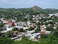
San Juan de los Morros City
-
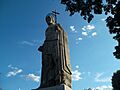
Evening at the San Juan Bautista monument
-
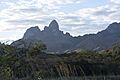
Morros de San Juan mountains
See also
 In Spanish: San Juan de los Morros para niños
