Santa Nella, California facts for kids
Quick facts for kids
Santa Nella, California
|
|
|---|---|

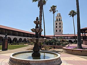
Hotel Mission de Oro
|
|
| Country | |
| State | |
| County | Merced |
| Named for | An English language corruption of the Spanish word centinela ("sentinel") |
| Area | |
| • Total | 4.683 sq mi (12.129 km2) |
| • Land | 4.683 sq mi (12.129 km2) |
| • Water | 0 sq mi (0 km2) 0% |
| Elevation | 154 ft (47 m) |
| Population
(2020)
|
|
| • Total | 2,211 |
| • Density | 472.13/sq mi (182.29/km2) |
| Time zone | UTC-8 (Pacific) |
| • Summer (DST) | UTC-7 (PDT) |
| ZIP code |
95322
|
| Area code | 209 |
| GNIS feature IDs | 1659597, 2583129 |
Santa Nella is a small community in Merced County, California. It's known as a "census-designated place" (CDP), which means it's a special area defined by the government for counting people. It sits about 10 miles (16 km) west of Los Banos.
In 2020, about 2,211 people lived in Santa Nella. This was a jump from 1,380 people in 2010. For a long time, Santa Nella has been a popular stop for travelers. Back in the 1800s, it was called Rancho de Centinela, which means "Sentinel Ranch" in Spanish. Today, major roads like Interstate 5 and State Route 33 pass through the area.
Contents
What's in a Name?
The name "Santa Nella" might sound like it refers to a saint, but it doesn't! There isn't a saint named "Nella." The name actually comes from a changed English version of the Spanish word centinela. This word means "sentinel," like a guard or lookout. It refers to an old building called the Centinela Adobe that used to be nearby.
A Look Back in Time
Santa Nella started as a ranch called Rancho de Centinela around 1810. Early settlers from San Juan Bautista and Monterey used it to raise horses. The original Centinela Adobe was a one-story building where people lived. It was located along an old road called El Camino Viejo a Los Ángeles.
Over time, many horses escaped, and there were conflicts with Native Americans. This made the ranch difficult to manage. Later, in 1843, the land became part of a larger ranch called Rancho San Luis Gonzaga.
During the California Gold Rush, Santa Nella became an important stopping point for travelers. People on stagecoaches and other journeys would stop here. In the 1860s, a two-story adobe house was built by Basque sheep farmers. A wooden barn was added in the 1870s. These buildings were local landmarks for many years.
By 1966, the old house and barn were gone. A new roadside stop was built on the site along State Route 33. This is when the name of the place became "Santa Nella." In 1981, it was officially recognized as "Santa Nella Village." Then, in 2010, it became a census-designated place called "Santa Nella."
Where is Santa Nella?
Santa Nella is located in western Merced County. It sits on the western edge of California's large Central Valley. Interstate 5 runs through the northern part of the community. You can get there from Exit 407, which is also California State Route 33.
- I-5 goes north about 66 miles (106 km) to Stockton.
- It goes southeast about 160 miles (257 km) to the Bakersfield area.
- State Route 33 goes north from Santa Nella about 11 miles (18 km) to Gustine.
- It goes southeast about 12 miles (19 km) to Los Banos.
The community covers an area of about 4.7 square miles (12.1 km²), and it's all land.
Nearby places to visit include the San Joaquin Valley National Cemetery. This cemetery also has the California Korean War Veterans Memorial. You can also find the San Luis Reservoir and the Forebay Golf Course close by.
Santa Nella's Weather
| Climate data for Santa Nella, California | |||||||||||||
|---|---|---|---|---|---|---|---|---|---|---|---|---|---|
| Month | Jan | Feb | Mar | Apr | May | Jun | Jul | Aug | Sep | Oct | Nov | Dec | Year |
| Record high °F (°C) | 73 (23) |
79 (26) |
85 (29) |
96 (36) |
104 (40) |
106 (41) |
110 (43) |
107 (42) |
105 (41) |
98 (37) |
82 (28) |
75 (24) |
110 (43) |
| Mean daily maximum °F (°C) | 55.3 (12.9) |
61.5 (16.4) |
66.7 (19.3) |
72.1 (22.3) |
80.1 (26.7) |
86.6 (30.3) |
93.0 (33.9) |
92.1 (33.4) |
87.9 (31.1) |
79.0 (26.1) |
65.5 (18.6) |
56.0 (13.3) |
74.6 (23.7) |
| Daily mean °F (°C) | 46.5 (8.1) |
51.7 (10.9) |
58.3 (14.6) |
60.6 (15.9) |
67.1 (19.5) |
72.8 (22.7) |
78.5 (25.8) |
77.9 (25.5) |
74.1 (23.4) |
66.3 (19.1) |
55.2 (12.9) |
47.2 (8.4) |
63.0 (17.2) |
| Mean daily minimum °F (°C) | 37.8 (3.2) |
42.0 (5.6) |
45.9 (7.7) |
49.0 (9.4) |
54.3 (12.4) |
59.0 (15.0) |
64.0 (17.8) |
63.6 (17.6) |
60.3 (15.7) |
53.5 (11.9) |
45.1 (7.3) |
38.0 (3.3) |
51.0 (10.6) |
| Record low °F (°C) | 19 (−7) |
22 (−6) |
27 (−3) |
30 (−1) |
35 (2) |
40 (4) |
44 (7) |
45 (7) |
45 (7) |
33 (1) |
24 (−4) |
14 (−10) |
14 (−10) |
| Average precipitation inches (mm) | 2.20 (56) |
1.96 (50) |
1.56 (40) |
0.68 (17) |
0.40 (10) |
0.06 (1.5) |
0.02 (0.51) |
0.07 (1.8) |
0.20 (5.1) |
0.53 (13) |
1.46 (37) |
1.55 (39) |
10.69 (270.91) |
| Source: National Weather Service | |||||||||||||
Getting Around
Interstate 5 and State Route 33 meet in Santa Nella. Another important road, State Route 152, runs south of town. This road connects nearby Los Banos to the Santa Clara Valley.
You can also use public transportation in Santa Nella. Merced County's "The Bus" offers a service called Dial-A-Ride. This service connects Santa Nella with other communities like Gustine, Los Banos, and Dos Palos.
What Santa Nella is Known For
Santa Nella is a very important stopping point for people traveling on Interstate 5. This highway is a major route between Los Angeles and either the San Francisco Bay Area or Sacramento. Because of this, Santa Nella has many places for travelers to stop.
You can find:
- Different fast food restaurants
- Motels for a place to sleep
- Gas stations to fill up your car
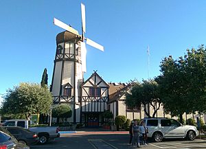
Some well-known places include Hotel Mission de Oro, The Kitchen at the Mission, Pea Soup Andersen's restaurant, In-N-Out Burger, and the Santa Nella Food Center.
People of Santa Nella
In 2010, the population of Santa Nella was 1,380 people. The community has grown since then, reaching 2,211 people in 2020. Most of the people living in Santa Nella live in households, not in group homes or institutions.
About one-third of the population is under 18 years old. The average age of people living in Santa Nella is about 30 years old.
See also
 In Spanish: Santa Nella (California) para niños
 | Frances Mary Albrier |
 | Whitney Young |
 | Muhammad Ali |


