Santa Rosa Island (Florida) facts for kids
Quick facts for kids
Santa Rosa Island
The Island of Santa Rosa
|
|
|---|---|
| Nickname(s):
SRI
|
|
| Country | United States |
| State | Florida |
| County | Escambia, Santa Rosa, Okaloosa County, Florida |
| Time zone | UTC-6 (CST) |
| Area code(s) | 850 |

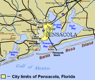
Santa Rosa Island is a long, narrow island in Florida, USA. It stretches about 40 miles (64 km) along the coast. This island is known as a barrier island, which means it protects the mainland from ocean storms.
You can find several communities on Santa Rosa Island. These include Pensacola Beach, Navarre Beach, and Okaloosa Island. On the side of the island facing the mainland, there are two large bodies of water: Pensacola Bay to the west and Choctawhatchee Bay to the east. These bays are connected by a waterway called Santa Rosa Sound.
Santa Rosa Island has faced many strong storms over the years. These include hurricanes like Erin and Opal in 1995, Ivan in 2004, and Dennis in 2005. Even with these storms, parts of the island are kept safe from building projects. These protected areas are part of the Gulf Islands National Seashore.
Contents
Island History
Early Explorers and Settlements
Spanish explorers, called Conquistadors, first visited Santa Rosa Island around 1519. Later, in August 1559, an expedition led by Tristan de Luna arrived. They came from Vera Cruz in New Spain to start a settlement.
However, these early Spanish settlements did not last long. Storms caused a lot of damage, and there wasn't enough food. Conflicts with the local Pensacola natives also made things difficult. Because of these problems, the Spanish left the area in 1561.
Spain tried to settle the island again in 1722. They built a colony called Presidio Isla de Santa Rosa. But hurricanes hit the colony in 1741 and 1752. These storms forced the settlers to move across the bay to what is now Pensacola. Another hurricane in 1762 destroyed what was left on the island.
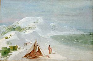
After a treaty in 1823, the Creek people lived on Santa Rosa Island. A famous painter named George Catlin visited in 1835. He painted a Creek family on the island, showing them catching and drying fish.
The American Civil War
During the American Civil War, some Union soldiers in Florida moved to Fort Pickens. This fort is located on the western end of Santa Rosa Island.
A battle took place on the island on October 9, 1861. Confederate General Richard Anderson led 1200 men across from the mainland. They tried to capture Fort Pickens but were not successful.
Later in 1863, the Union army set up a recruiting station on the eastern part of the island. By 1864, many people who supported the Union joined the soldiers there. The fort stayed under Union control throughout the entire war.
The 20th Century and Beyond
In 1929, the U.S. War Department decided Fort Pickens was no longer needed. They sold Santa Rosa Island to Escambia County, Florida, for $10,000. Ten years later, the county gave the island back to the federal government. They hoped it would become a national monument to protect Fort Pickens.
President Roosevelt created the Santa Rosa Island National Monument in 1939. However, it was closed seven years later. Today, Fort Pickens and other areas are part of the Gulf Islands National Seashore, which started in 1971.
In 1950, a part of Santa Rosa Island was given to Okaloosa County. This area is now known as Okaloosa Island. It has a long beach road that used to be open to the public. Now, for safety reasons, it is guarded or blocked. There are also military missile test sites on Santa Rosa Island.
The island continues to be hit by tropical storms. In 1995, Hurricanes Erin and Opal made landfall here. Hurricane Dennis hit in July 2005 with winds of 120 miles per hour (193 km/h). This was the strongest storm to hit the island. Tropical Storm Claudette also hit in 2009.
Between 2008 and 2009, a sunken Spanish ship was found near the island. This discovery helped confirm the reports of Tristan de Luna's 1559 expedition. It showed where his settlement in Pensacola might have been.
Santa Rosa Island is also used for military training. One of the final missions for the US Army's Ranger School takes place here.
See also
 In Spanish: Isla Santa Rosa (Florida) para niños


