
Sarmenstorf facts for kids
Quick facts for kids
Sarmenstorf
|
||
|---|---|---|
 |
||
|
||

Sarmenstorf
Location in Switzerland

Sarmenstorf
Location in Canton of Aargau
|
||
| Country | Switzerland | |
| Canton | Aargau | |
| District | Bremgarten | |
| Area | ||
| • Total | 8.3 km2 (3.2 sq mi) | |
| Elevation | 534 m (1,752 ft) | |
| Population
(Dec 2020 )
|
||
| • Total | 2,913 | |
| • Density | 351.0/km2 (909/sq mi) | |
| Postal code |
5614
|
|
| Surrounded by | Bettwil, Büttikon, Fahrwangen, Hilfikon, Kallern, Meisterschwanden, Seengen, Uezwil | |


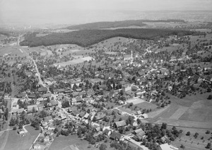
Sarmenstorf is a small town, also called a municipality, in the Bremgarten area of the canton of Aargau in Switzerland. It's a lovely place with a rich history!
Contents
History of Sarmenstorf
The very first people to live in the Sarmenstorf area built a special burial mound at a place called Zigiholz. This mound dates back to the neolithic period, which was a very long time ago when people first started farming.
Later, around the 1st Century AD, during the Roman era, a large Roman house, known as a villa, was built at Murimooshau. It even had a fancy porch (a portico) and a bath house! Around the same time, there was also a burial ground for the Alemanni people nearby.
Sarmenstorf was first written about in 1173. Back in the Middle Ages, many important religious houses, like Einsiedeln Abbey and Wettingen Abbey, owned land here. These abbeys were like monasteries where monks or nuns lived.
For a long time, the powerful House of Habsburg controlled the area starting in 1306. They had the right to make important legal decisions. Later, in 1415, these rights went to Lucerne, and then in 1425, to the Old Swiss Confederacy, which was like an early version of Switzerland.
The local church is first mentioned in 1185. The oldest church building on the site of the current Holy Cross church was from the Carolingian time. A new church was built in 1622, and then replaced by the beautiful late Baroque church you see today, built between 1778 and 1785. It has been carefully looked after and renovated over the years. There is also a Chapel of St. Wendelin, which became a special place for pilgrims even before it was built in 1659. A newer chapel was built in 1746-47.
For a short time, from 1798 to 1803, Sarmenstorf was an important district capital under the Canton of Baden.
Geography and Landscape
Sarmenstorf covers an area of about 8.3 square kilometers (about 3.2 square miles). A large part of this land, almost 60%, is used for farming. About 28.7% is covered by forests, and 11.5% has buildings or roads.
The municipality is located in the Bremgarten district, right on the edge of a hilly area called the Lindenberg. Sarmenstorf itself is a haufendorf village. This means it's an old-fashioned village that grew without a strict plan, so its buildings are often close together around a central area.
Sarmenstorf's Coat of Arms
The blazon (the official description) of Sarmenstorf's coat of arms says: Gules two Pilgrim Stocks Or in saltire. This means it shows two golden pilgrim staffs crossed over each other on a red background. These staffs are like walking sticks used by pilgrims on their journeys.
People and Population
Sarmenstorf has a population of about 2,900 people. Around 10.4% of the people living here are from other countries. Over the last ten years, the number of people living in Sarmenstorf has grown by about 14.1%.
Most people in Sarmenstorf speak German (about 93.8%). Italian is the second most common language (2.2%), followed by Spanish (0.7%).
Let's look at the age groups in Sarmenstorf:
- About 11.4% of the population are children aged 0 to 9 years old.
- Around 14.0% are teenagers aged 10 to 19.
- Young adults (20-29 years old) make up about 11.7%.
- People aged 30-39 are 12.3% of the population.
- The largest group is 40-49 year olds, making up 19.9%.
- People aged 50-59 are 12.7%.
- Seniors aged 60-69 are 9.1%.
- Those aged 70-79 are 5.8%.
- People aged 80-89 are 2.5%.
- And a small group, 0.5%, are 90 years old or older.
In 2007, the most popular political party in the federal election was the SVP, which got 35.5% of the votes. Other popular parties included the CVP, the FDP, and the SP.
Many adults in Sarmenstorf (about 73.4%) have completed higher education, either at a university or a specialized college. In the 2008/2009 school year, there were 208 students in primary school and 106 students in secondary school in the municipality.
Here's how the population of Sarmenstorf has changed over time:
| Historical population | ||
|---|---|---|
| Year | Pop. | ±% |
| 1650 | 450 | — |
| 1850 | 1,240 | +175.6% |
| 1900 | 1,212 | −2.3% |
| 1950 | 1,398 | +15.3% |
| 2000 | 2,146 | +53.5% |
Important Heritage Site
The Zigiholz is a very old tumulus (a type of burial mound) from the Stone Age. It is so important that it is listed as a Swiss heritage site of national significance. This means it's a protected historical treasure for the whole country!
Economy and Jobs
In 2007, Sarmenstorf had a low unemployment rate of 2.08%. This means most people who wanted jobs had them.
The economy is divided into three main parts:
- The primary sector (like farming) had 63 people working in 21 businesses.
- The secondary sector (like manufacturing and building) employed 210 people in 24 businesses.
- The tertiary sector (like services, shops, and offices) had 336 people working in 59 businesses.
Many people who live in Sarmenstorf actually work outside the municipality (about 74.8%). However, 248 people travel into Sarmenstorf for work. Most people (59%) use a private car to get to work, while 8.1% use public transportation.
Religion
Based on the 2000 census, most people in Sarmenstorf are Roman Catholic (about 64.9%). The next largest group, about 19.9%, belong to the Swiss Reformed Church. A very small number of people (0.09%) are part of the Christian Catholic faith.
See also
 In Spanish: Sarmenstorf para niños
