Sciota, Illinois facts for kids
Quick facts for kids
Sciota, Illinois
Amicus, Clarkesville
|
|
|---|---|

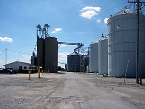
Farmers Elevator Company in Sciota, 2013
|
|
| Etymology: Named for Sciota Township | |

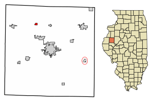
Location in McDonough County, Illinois
|
|
| Country | United States |
| State | Illinois |
| County | McDonough |
| Township | Sciota |
| Founded | 1867 |
| Government | |
| • Type | Village |
| Area | |
| • Total | 0.31 sq mi (0.81 km2) |
| • Land | 0.31 sq mi (0.81 km2) |
| • Water | 0.00 sq mi (0.00 km2) |
| Elevation | 758 ft (231 m) |
| Population
(2020)
|
|
| • Total | 38 |
| • Density | 121.79/sq mi (46.98/km2) |
| Time zone | UTC-6 (CST) |
| • Summer (DST) | UTC-5 (CDT) |
| ZIP code |
61475
|
| Area code(s) | 309 |
| FIPS code | 17-68198 |
Sciota (pronounced sigh-OH-duh) is a small village located in McDonough County, Illinois, United States. In 2020, only 38 people lived there. This was a decrease from 61 people in 2010.
Contents
The Story of Sciota: How the Village Got Its Name
Sciota was first planned in September 1867 by a man named William B. Clarke. He named the new settlement "Clarkesville" after himself. However, there was already another town in Illinois called Clarksville (without the "e").
To avoid confusion, when the town's post office opened in February 1868, it was given a different name: "Amicus." This meant the town had one name and its post office had another! To fix this, the people living there decided to change both names to "Sciota."
Why the Name Sciota?
The new name "Sciota" came from the township where the village is located. The township itself was named after the Scioto River in Ohio. The state government of Illinois officially approved the name change on March 29, 1869.
Early Buildings and Businesses
In the early years, important buildings were constructed in Sciota:
- A Christian church was built in 1869.
- A Baptist church followed in 1871.
- A school building was completed in 1872.
By 1878, Sciota became a very important place for selling grain in McDonough County. Farmers mainly grew corn and oats back then. Today, the area around the village is still covered with fields of corn and soybeans.
A local newspaper called The Sciota Sentinel was published around 1895. However, only one copy of this newspaper seems to still exist today.
Where is Sciota Located?
Sciota is found in the northern part of McDonough County, Illinois. It sits at an elevation of about 758 feet (231 meters) above sea level.
The village is located about half a mile (0.8 kilometers) north of Illinois Route 9. It is also about 10 miles (16 kilometers) northwest of Macomb, which is the main town and county seat of McDonough County.
Land and Water Around Sciota
Sciota covers an area of about 0.31 square miles (0.81 square kilometers), and all of this area is land. The village is situated just east of where a small stream begins. This stream flows into Spring Creek, which then flows into the East Fork of the La Moine River. All these waterways are part of the larger Illinois River system.
The land around Sciota is known for its excellent prime farmland. The soil in this area is classified as Mollisols, which are very fertile and good for growing crops.
Who Lives in Sciota? A Look at the Population
The number of people living in Sciota has changed over the years. Here's how the population has looked:
| Historical population | |||
|---|---|---|---|
| Census | Pop. | %± | |
| 1880 | 349 | — | |
| 1890 | 238 | −31.8% | |
| 1900 | 238 | 0.0% | |
| 1910 | 160 | −32.8% | |
| 1920 | 195 | 21.9% | |
| 1930 | 150 | −23.1% | |
| 1940 | 156 | 4.0% | |
| 1950 | 128 | −17.9% | |
| 1960 | 120 | −6.2% | |
| 1970 | 101 | −15.8% | |
| 1980 | 81 | −19.8% | |
| 1990 | 68 | −16.0% | |
| 2000 | 58 | −14.7% | |
| 2010 | 61 | 5.2% | |
| 2020 | 38 | −37.7% | |
| U.S. Decennial Census | |||
According to the 2010 census, there were 61 people living in Sciota. These people lived in 26 different homes, and 12 of these were families. At that time, all the residents of the village were White.
Getting Around and Village Services
Sciota can be reached by public roads from the south. McDonough County road East 800th Street (also called County Highway 13) connects to Illinois Route 9 about half a mile south of the village. This road is known as Buel Street inside Sciota and continues north to the county line.
Railroad Connections
The village is also served by the Keokuk Junction Railway. As of 2010, there were two rail sidings (short tracks where trains can wait). There is one crossing where the road meets the train tracks. This crossing has crossbuck signs with flashing lights and a warning bell to keep people safe.
Water and Sewer Systems
In 2001, Sciota received a special grant of $400,000 from the state. This money was used to connect the village to the Good Hope water supply system and to build a water tower. So, Sciota has a system for clean water.
However, the village does not have a central sewer system for waste water. Instead, residents use septic systems at their homes to handle sewage disposal.
Education in Sciota
Sciota is part of the West Prairie Community Unit School District 103. Students in elementary school attend North Elementary in Good Hope. The West Prairie High School used to be in Sciota but is now located in Colchester, Illinois.
See also
 In Spanish: Sciota (Illinois) para niños


