
Scott, New York facts for kids
Quick facts for kids
Scott, New York
|
|
|---|---|

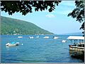
Skaneateles Lake marina, hamlet of Fair Haven
|
|

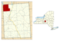
Location within Cortland County and New York
|
|

Scott, New York
Location in the United States

Scott, New York
Location in New York
|
|
| Country | United States |
| State | New York |
| County | Cortland |
| Government | |
| • Type | Town Council |
| Area | |
| • Total | 22.39 sq mi (57.99 km2) |
| • Land | 22.24 sq mi (57.61 km2) |
| • Water | 0.15 sq mi (0.38 km2) |
| Elevation | 1,795 ft (547 m) |
| Population
(2010)
|
|
| • Total | 1,176 |
| • Estimate
(2016)
|
1,139 |
| • Density | 51.21/sq mi (19.77/km2) |
| Time zone | UTC-5 (Eastern (EST)) |
| • Summer (DST) | UTC-4 (EDT) |
| ZIP code |
13077
|
| Area code(s) | 607 |
| FIPS code | 36-023-65915 |
| GNIS feature ID | 0979477 |
Scott is a small town located in Cortland County, New York, United States. In 2010, about 1,176 people lived there. The town was named after a famous military leader, General Winfield Scott. It is in the northwestern part of Cortland County, a bit northwest of the City of Cortland.
Contents
History of Scott
Scott is part of an area that was once known as the Central New York Military Tract. The very first European settler arrived in this area around the year 1799.
The town of Scott was officially created in 1815. It was formed from a part of the town of Preble. By 1865, the population of Scott was about 1,149 people.
Interestingly, the town is the birthplace of James Henry Salisbury. He was a doctor who later became famous for creating the Salisbury Steak!
Geography and Nature

The town of Scott covers a total area of about 58.1 square kilometers (22.4 square miles). Most of this area, about 57.7 square kilometers (22.3 square miles), is land. The rest, about 0.4 square kilometers (0.15 square miles), is water.
The western edge of Scott touches the border of Cayuga County. The northern edge borders Onondaga County. A main road, New York State Route 41, runs north and south through Scott.
Lakes and Streams
The southern end of Skaneateles Lake is located in the northwestern part of Scott. This lake is one of the beautiful Finger Lakes. Grout Brook, a stream known for trout fishing, flows into Skaneateles Lake from the town.
The small community of Fair Haven in Scott, along with nearby Glen Haven and Spafford Landing, is a lovely spot for visitors and residents. You can find places to stay, eat, and even a marina for boats there.
The eastern two-thirds of the town has streams like Cold Brook and Factory Brook. These streams flow south into the West Branch of the Tioughnioga River. This river is part of the larger Susquehanna River system.
Hewitt State Forest
Hewitt State Forest, also called Cortland Reforestation Area #1, is New York State’s very first State Forest. It covers 937 acres and is located in the Town of Scott, just off State Route 41 on Hewitt Road. It's a great place to explore nature!
Population and People
| Historical population | |||
|---|---|---|---|
| Census | Pop. | %± | |
| 1820 | 775 | — | |
| 1830 | 1,452 | 87.4% | |
| 1840 | 1,368 | −5.8% | |
| 1850 | 1,293 | −5.5% | |
| 1860 | 1,211 | −6.3% | |
| 1870 | 1,083 | −10.6% | |
| 1880 | 980 | −9.5% | |
| 1890 | 987 | 0.7% | |
| 1900 | 852 | −13.7% | |
| 1910 | 718 | −15.7% | |
| 1920 | 625 | −13.0% | |
| 1930 | 544 | −13.0% | |
| 1940 | 535 | −1.7% | |
| 1950 | 527 | −1.5% | |
| 1960 | 600 | 13.9% | |
| 1970 | 805 | 34.2% | |
| 1980 | 1,193 | 48.2% | |
| 1990 | 1,167 | −2.2% | |
| 2000 | 1,193 | 2.2% | |
| 2010 | 1,176 | −1.4% | |
| 2016 (est.) | 1,139 | −3.1% | |
| U.S. Decennial Census | |||
Based on the census from 2000, there were 1,193 people living in Scott. These people lived in 417 households, and 321 of these were families. The population density was about 53.6 people per square mile.
Most of the people living in Scott were White (98.32%). A small percentage were from other racial backgrounds. About 0.17% of the population identified as Hispanic or Latino.
About 41.7% of households had children under 18 living with them. Most households (64.7%) were married couples living together. The average household had 2.86 people, and the average family had 3.18 people.
The population in Scott was spread out by age:
- 29.9% were under 18 years old.
- 7.5% were between 18 and 24.
- 31.3% were between 25 and 44.
- 23.3% were between 45 and 64.
- 8.0% were 65 years or older.
The average age of people in Scott was 36 years. For every 100 females, there were about 102.9 males.
The average income for a household in the town was $39,000 per year. For families, the average income was $43,438. About 9.9% of the population lived below the poverty line. This included 9.8% of those under 18 and 4.0% of those 65 or older.
Communities and Places in Scott
- East Scott – This is a small hamlet located near the eastern border of the town, along County Road 102.
- Fair Haven – Another hamlet found on the eastern shore of Skaneateles Lake, close to the northern town line. It's different from Glen Haven, which is on the western side of the lake. The Glen Haven District No. 4 School and Public Library here is a historic building, listed on the National Register of Historic Places in 1997.
- Grout Mill – A hamlet located about one mile west of the main Scott village, near the western town border.
- Scott – This is the main hamlet of Scott. It's located on Route 41 where it meets County Road 101. It used to be called "Scott Center."
Images for kids
-
Skaneateles Lake marina, hamlet of Fair Haven
-
Location within Cortland County and New York
See also
 In Spanish: Scott (Nueva York) para niños
