
Seaforth Channel facts for kids
Quick facts for kids Seaforth Channel |
|
|---|---|
| French: Canal Seaforth | |

Ivory Island Lighthouse at the northwest entrance to Seaforth Channel
|
|

Seaforth Channel
Location in British Columbia
|
|
| Coordinates | 52°14′48″N 128°17′58″W / 52.2467°N 128.2995°W |
| Part of | Inside Passage |
| Primary outflows | Milbanke Sound Lama Passage |
| Basin countries | Canada |
| Designation | Voluntary Tanker Exclusion Zone |
| Islands | Athlone Island Dufferin Island Horsfall Island Campbell Island Denny Island Ivory Island Beasley Islands |
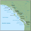
The Seaforth Channel is a waterway located on the Central Coast of British Columbia, a province in Canada. It is an important part of the Inside Passage. This passage is a long marine highway, about 950 miles (1,529 km) long. It stretches from Seattle, Washington, all the way to Juneau, Alaska.
The Seaforth Channel is used by ferries, including the Prince Rupert/Port Hardy BC ferry route. It runs west from Denny Island towards Milbanke Sound. This channel is bordered by Denny Island, Campbell Island, and the Wright group of islands. In 2016, an incident involving a tug and barge caused an oil spill here. This event led to a major cleanup effort and new plans to protect Canada's oceans.
Contents
Exploring Seaforth Channel's Geography
The Seaforth Channel has many interesting natural features. Lama Passage connects the Seaforth Channel to Fitzburgh Sound. Dryad Point is located across from Saunders Island where these waterways meet.
- Wood Island and Ark Island are close to the shore. They are found where Seaforth Channel and Troup Passage join.
- Newby Island, Munsie Point, and Christiansen Point are a bit further west.
- Nose Island is west of Christiansen Point. It has a tall, noticeable tree about 60 meters (197 feet) high.
Ivory Island, with its lighthouse, marks the northwest entrance to Seaforth Channel. People have known since the 1800s that the northern shores of the channel are very uneven. They have many bays and inlets. The area around the Beazley Islands is also tricky. It has many small islands and hidden rocks.
The southern shore of Seaforth Channel is smoother. After passing Athlone, Dufferin, Horsfall, and Campbell islands, the channel turns sharply. It then goes between Campbell Island and Denny Island. The channel continues along Denny Island to where it meets Lama Passage.
Denniston Point on Dufferin Island is another notable spot. Idol Point is on the south side of the channel. Bush Point is also located along Seaforth Channel.
The Inside Passage Shipping Route

The Inside Passage is a coastal shipping route. It uses a network of waterways that wind through islands. This route stretches along the Pacific coast of North America. It goes from Alaska down to Washington state. Ships often use the Inside Passage when the open Pacific Ocean is too rough.
Today, it's like a marine highway. You can see cruise ships, cargo ships, tugboats, and fishing boats. Ferries from the Alaska Marine Highway, BC Ferries, and Washington State Ferries also use it. British Columbia's part of the Inside Passage has a huge coastline. It includes areas like the Strait of Georgia and the Hecate Strait.
By the 1880s, sailors already had a preferred route. They would travel from Queen Charlotte Sound to Dixon Entrance. This route included Fitzhugh Sound, Lama Passage, and Seaforth Channel. Lama Passage connected Seaforth Channel with Fisher Channel. The Seaforth Channel and Lama Passage meet near the northern end of Campbell Island. Ships still prefer Seaforth Channel when the weather is bad offshore.
Protecting the Environment: The 2016 Oil Spill
On October 13, 2016, a tugboat named Nathan E Stewart ran aground. It was pulling an empty oil barge called DBL 55. The accident happened on Edge Reef near Athlone Island. This area is at the entrance to Seaforth Channel. It is also part of the traditional lands of the Heiltsuk Nation.
The accident caused over 100,000 liters (26,417 gallons) of fuel to spill. The tugboat itself held about 200,000 liters (52,834 gallons) of industrial oils. The Seaforth Channel is in a "Voluntary Tanker Exclusion Zone." This means large oil tankers are asked to avoid the area. However, smaller vessels like this tugboat were allowed to pass without a local pilot. This was common if the crew met certain experience standards.
The fuel spill happened about 20 kilometers (12 miles) west of Bella Bella. This is the main community of the Heiltsuk Nation. The spill threatened many local species. This included clam beds that provide income for the community. A ban on shellfish harvesting was put in place. The spill also affected the Great Bear Rainforest. This is the largest untouched old-growth forest in the world.
The Canadian Coast Guard led the cleanup. Other groups, like the Western Canada Marine Response Corporation, also helped. The submerged tugboat was eventually pumped out and raised. However, oil was found in several coves. Bad weather made the cleanup difficult.
Many people, including the Heiltsuk Nation, felt the cleanup was too slow. Canada's Prime Minister Justin Trudeau also called the response "unacceptable." This incident highlighted concerns about how prepared Canada was for such spills. It also raised questions about future shipping traffic.
In response, Prime Minister Trudeau announced a $1.5 billion plan. This plan aims to improve marine safety. It also focuses on restoring ocean ecosystems. And it will fund research into better oil spill cleanup methods.
"The ongoing incident at Bella Bella is unacceptable...It's time for a change."
—Prime Minister Justin Trudeau
Images for kids
-
Map showing the Inside Passage route
