Seaman Range facts for kids
Quick facts for kids Seaman Range |
|
|---|---|

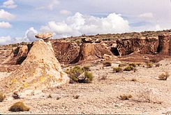
Weepah Spring Wilderness at Timber Mountain
|
|
| Highest point | |
| Elevation | 8,442 ft (2,573 m) |
| Dimensions | |
| Length | 30 mi (48 km) NNE (10 mi north section, NW) |
| Width | 9 mi (14 km) (widest at Timber Mountain massif, northwest section, ~6 mi) |
| Geography | |
| Country | United States |
| Communities | Hiko and Crystal Springs |
| Topo map | USGS Timber Mountain Pass East |
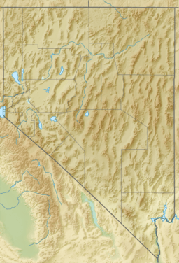
The Seaman Range is a mountain range in Nevada, a state in the western United States. It stretches for about 30 miles (48 km) through Lincoln and Nye counties.
This mountain range sits at the southern edge of the large White River Valley. To its west is Coal Valley. The Seaman Range also guides the path of the White River. The river flows south, then turns southeast, and finally southwest. It heads towards towns like Hiko and the Key Pittman Wildlife Management Area.
In the south-central part of the range, you'll find the Timber Mountain massif. A massif is a compact group of mountains. This area also forms the White River Narrows. The Weepah Spring Wilderness is a protected natural area located near Timber Mountain.
Contents
Exploring the Seaman Range
The Seaman Range is made up of two main parts. The northern part extends about 10 miles northwest from Timber Mountain. This section is at the southern end of the White River Valley.
Timber Mountain: A Key Feature
Timber Mountain is a very important part of the range. It stands tall at 8,442 feet (2,573 meters). The entire southern part of the range stretches for about 20 miles. It goes in a south-southwesterly direction.
Parallel Mountain Ranges
Many mountain ranges and valleys in this area run in a similar direction. This is a common feature of the Basin and Range region. The Basin and Range is a large area in the western United States where the land has been stretched and broken into parallel mountains and valleys.
Looking from west to east, you can see this pattern. It includes the Golden Gate Range, Coal Valley, the Seaman Range, and a part of the White River. Further east are Delamar Valley and Dry Lake Valley, the Burnt Springs Range, and the Delamar Mountains. Even further east, you'll find a section of Meadow Valley Wash.
Getting to the Seaman Range
There are a few ways to reach the Seaman Range.
Main Roads and Access Points
Nevada State Route 318 runs along the southeast, east, and part of the northeast sides of the range. This road follows the White River. It starts from towns like Hiko and Crystal Springs. These towns are about 20 miles south of Timber Mountain. Route 318 continues north into the eastern side of White River Valley. It eventually reaches Lund, which is about 50 miles away.
Dirt Roads for Exploration
If you want to explore more, there are dirt roads. Seaman Wash Road is an unpaved road on the southwest edge of the range. It leads to the center-south of Coal Valley and the Coal Valley Reservoir. This area has interesting landforms, including dry lakebeds called saltflats. Other dirt roads from eastern Coal Valley or Seaman Wash Road can take you to the western, southwestern, and northwestern parts of the Seaman Range.
 | May Edward Chinn |
 | Rebecca Cole |
 | Alexa Canady |
 | Dorothy Lavinia Brown |


