Sheridan, Colorado facts for kids
Quick facts for kids
Sheridan, Colorado
|
|
|---|---|
| City of Sheridan | |

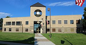
The Sheridan City Hall.
|
|

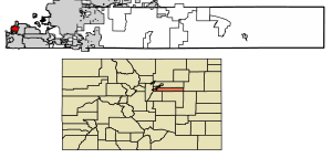
Location of the City of Sheridan in Arapahoe County, Colorado.
|
|
| Country | |
| State | |
| County | Arapahoe County |
| City | Sheridan |
| Incorporated | April 1890 |
| Named for | Philip Sheridan |
| Government | |
| • Type | Home rule municipality |
| Area | |
| • Total | 2.29 sq mi (5.93 km2) |
| • Land | 2.22 sq mi (5.76 km2) |
| • Water | 0.07 sq mi (0.17 km2) |
| Elevation | 5,325 ft (1,623 m) |
| Population
(2020)
|
|
| • Total | 6,105 |
| • Density | 2,666/sq mi (1,029.5/km2) |
| Time zone | UTC-7 (MST) |
| • Summer (DST) | UTC-6 (MDT) |
| ZIP code |
80110
|
| Area code(s) | Both 303 and 720 |
| FIPS code | 08-69645 |
| GNIS feature ID | 0204714 |
Sheridan is a city in Arapahoe County, Colorado, United States. It's a special type of city called a home rule municipality, which means it has its own local government rules. Sheridan is also part of the larger Denver area. In 2020, about 6,105 people lived there.
Contents
Sheridan's Early Days: A Look at Its History
Sheridan started as a small community. It was once part of the Indian Territory.
First Settlers and the Name Change
The first European settler in the area was John McBroom. He arrived in the spring of 1859. John claimed about 160 acres of land. The town was first called Petersburg. John built a log cabin near Bear Creek. He became a successful farmer. He sold his crops in Denver.
John's brother, Isaac McBroom, joined him in 1860. Isaac also claimed land. He is given credit for planning the town of Sheridan. Isaac also changed the town's name from Petersburg to Sheridan. You can visit Isaac McBroom's cabin at the Littleton Historical Museum.
Another Important Pioneer: Peter Magnes
Peter Magnes was another key person in Sheridan's early history. He was a farmer from Sweden. Peter came to the United States when he was 26. In 1859, his first daughter was born near Cherry Creek.
Peter also bought 160 acres of land. He built a small log cabin. In 1865, Magnes planned the town of Petersburg. He encouraged other Swedish families to move there. This early town had a railroad, a hotel, and a post office. It also had a blacksmith shop, a church, and a newspaper.
Becoming an Official City
Citizens wanted Sheridan to become an official city in January 1890. There were some discussions about the city's borders. The final plans were approved in February 1890. On April 14, 1890, the town of Sheridan officially became a city.
How Sheridan Got Its Name
Sheridan is named after U.S. Army General Philip H. Sheridan. General Sheridan started Fort Logan. This fort was first called "Camp close to Denver." It was built on land known as the Johnson Tract. The location was chosen for its water, railroad access, and views. It was also far enough from Denver's busy areas.
The military post helped Sheridan grow. Later, the post closed down. Today, it is a mental health facility. It is located right next to Sheridan. Sheridan continues to be an important community. It has many new development projects happening now.
Sheridan's Location and Size
Sheridan is located at 39°38′56″N 105°1′4″W / 39.64889°N 105.01778°W.
The city covers about 5.9 square kilometers (2.29 square miles). Most of this area is land. About 0.2 square kilometers (0.07 square miles) is water.
Population Changes Over Time
| Historical population | |||
|---|---|---|---|
| Census | Pop. | %± | |
| 1900 | 442 | — | |
| 1910 | 498 | 12.7% | |
| 1920 | 455 | −8.6% | |
| 1930 | 587 | 29.0% | |
| 1940 | 712 | 21.3% | |
| 1950 | 1,715 | 140.9% | |
| 1960 | 3,559 | 107.5% | |
| 1970 | 4,787 | 34.5% | |
| 1980 | 5,377 | 12.3% | |
| 1990 | 4,976 | −7.5% | |
| 2000 | 5,600 | 12.5% | |
| 2010 | 5,664 | 1.1% | |
| 2020 | 6,105 | 7.8% | |
| U.S. Decennial Census | |||
This table shows how Sheridan's population has changed. You can see how many people lived in the city during different years.
Schools in Sheridan
The Sheridan School District manages the public schools in the area.
Getting Around Sheridan: Transportation
Major Roads in Sheridan
Three main highways pass through the city of Sheridan:
 US 85 (South Santa Fe Drive) runs along the eastern side of the city. It connects Sheridan with Englewood.
 US 285 goes from east to west through the city. It connects Sheridan to Englewood and Denver.
 State Highway 88 (South Federal Boulevard) runs from south to north. It connects Sheridan to Englewood and Denver.
Public Transport: Buses and Light Rail
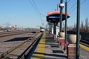
The Regional Transportation District (RTD) offers bus and light rail services in Sheridan. Light rail trains started serving the city on July 14, 2000. These trains were on the C and D Lines. The C Line stopped running here on January 10, 2021.
The Oxford-City of Sheridan station is the only light rail station in the city. The train platform is in Sheridan. However, you can only enter the station from Englewood.
See also
 In Spanish: Sheridan (Colorado) para niños
 | Emma Amos |
 | Edward Mitchell Bannister |
 | Larry D. Alexander |
 | Ernie Barnes |


