Sherman, Michigan facts for kids
Quick facts for kids
Sherman, Michigan
|
|
|---|---|

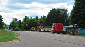
Looking south along North 13 Road (M-37)
|
|
| Country | United States |
| State | Michigan |
| County | Wexford |
| Townships | Antioch, Hanover, Springville, and Wexford |
| Settled | 1862 |
| Platted | 1869 |
| Incorporated | 1887 (village) |
| Disincorporated | 1940 |
| Elevation | 915 ft (279 m) |
| Time zone | UTC-5 (Eastern (EST)) |
| • Summer (DST) | UTC-4 (EDT) |
| ZIP code(s) |
49668 (Mesick)
|
| Area code(s) | 231 |
| GNIS feature ID | 1621586 |
Sherman is a small, unincorporated community in Wexford County, located in the U.S. state of Michigan. An unincorporated community means it doesn't have its own official government or exact borders.
Sherman is found in the northwest part of Wexford County. It sits right where four different townships meet: Antioch, Hanover, Springville, and Wexford.
This area was first settled in 1862. Sherman was one of the very first towns in Wexford County. It even served as the county's first main government center, called the county seat, from 1869 to 1881. Sherman became an official village in 1887. However, after 1920, a series of fires and people moving away caused it to become almost empty. The village stopped being an official village around 1940.
Contents
Where is Sherman Located?
Sherman is a small place in northwestern Wexford County. This area is part of Northern Michigan. The community is about 20 miles (32 km) north of the city of Cadillac.
Sherman's Unique Location
Sherman is special because it sits at the corner of four different civil townships:
- Wexford Township to the northwest
- Hanover Township to the northeast
- Springville Township to the southwest
- Antioch Township to the southeast
The land in Sherman is about 915 feet (279 meters) above sea level.
Roads and Nearby Towns
The main road through Sherman is M-37, also known as North 13 Road. Another important road, M-115, crosses M-37 about 1.5 miles (2.4 km) south in the village of Mesick.
Other nearby communities include:
- Buckley (about 5.5 miles north on M-37)
- Bagnall and Glengary (to the west)
- Wexford Corner (to the north)
- Harlan (to the northwest)
- Meauwataka (to the southwest)
- Baxter (to the northeast)
Natural Features Around Sherman
Briar Hill is a tall spot located southeast of Sherman. It's about 1,706 feet (520 meters) above sea level, making it one of the highest points in Michigan's Lower Peninsula. The area around it is part of the Manistee National Forest.
The Manistee River flows just north of Sherman. This part of the river is popular for boating and fishing. The bridge over the river on M-37 is called the Sherman Bridge. The North Country Trail, a long hiking trail, also passes through Sherman, crossing the bridge and following the river.
Local Services
Sherman no longer has its own post office. Mail for Sherman is handled by the Mesick 49668 ZIP Code. Students in Sherman attend schools within the Mesick Consolidated Schools district.
Sherman's History: From Settlement to Decline
| Historical population | |||
|---|---|---|---|
| Census | Pop. | %± | |
| 1900 | 427 | — | |
| 1910 | 260 | −39.1% | |
| 1920 | 108 | −58.5% | |
| U.S. Decennial Census | |||
The first European settler in the Sherman area was Benjamin Hall in 1862. He built his cabin near the Manistee River. This area was along the Northport State Road, which was an old trail. A bridge was built over the river in 1864, making travel easier.
In 1867, Lewis J. Clark opened a general store. The community became known as Manistee Bridge. A post office opened in 1868. Soon after, the town was renamed Sherman, honoring the famous Civil War general, William Sherman. This name was chosen by Sanford Gasser, who officially planned the town in 1869.
Becoming the County Seat
Wexford County was officially organized in 1869. Since Sherman was one of the earliest settlements, it was chosen as the first county seat. Most people in the county lived near Sherman at that time. Many Civil War veterans moved here, getting land from the government. The lumber and railroad industries were also growing, bringing more settlers.
Early businesses in Sherman focused on cutting down trees, known as the lumber industry. Many sawmills were built. The Manistee River made it easy to float logs to these mills. By 1872, the county finished building a two-story courthouse in Sherman. This made Sherman's role as the county seat even stronger.
By 1872, Sherman was growing with about 400 residents. It had hotels, stores, mechanic shops, a pharmacy, and sawmills. By 1877, it also had churches, a newspaper, flour mills, and more businesses.
The Battle for the County Seat
Even though Sherman was the county seat, other towns like Clam Lake (now Cadillac) and Manton wanted to be the county seat too. This led to a big argument called the "Battle of Sherman" or "Battle of Manton." This fight lasted through the 1870s.
The argument became very intense by 1877. Government meetings were tense, and sometimes people even fought physically. There were attempts to steal county records from the courthouse in Sherman. Important people, like Cadillac's mayor George A. Mitchell, tried to bribe officials to move the records.
There were many political scandals and threats. For example, a township supervisor was kidnapped to force him to resign! Despite all this, Sherman officials felt confident. In an April 1879 election, people voted 971 to 290 for Sherman to remain the county seat over Manton.
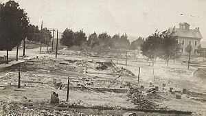
However, in 1880, a terrible fire destroyed most of Sherman's businesses. The courthouse survived, but the damage was so bad that the county moved its offices and records to Manton. This meant Sherman was no longer the county seat. Manton became the temporary county seat in 1881. Later, in 1882, Cadillac, which had a much larger population, became the permanent county seat.
Sherman as a Village
After the 1880 fire, Sherman was quickly rebuilt. In 1885, the old courthouse was bought and turned into a school. Sherman officially became a village in 1887. A map of the village was made in 1889.
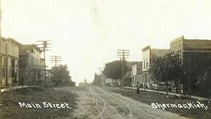
The Toledo, Ann Arbor, and North Michigan Railway expanded into the area by 1890. Sadly for Sherman, the railway went through Mesick to the south and then west, completely missing Sherman. Even without a direct train, Sherman was doing well by 1895. It had five sawmills, a bank, pharmacies, doctors, and many other businesses. The most famous building was the Exchange Hotel, a three-story hotel with 37 rooms. In 1900, a telegraph station was built. In the 1900 census, the village had 427 people.
Sherman was growing fast, but the lack of a direct railroad stopped its development. It continued as a lumber town and a stop for travelers. However, another huge fire in 1909 destroyed most of the business district. Only the Exchange Hotel remained. This fire caused many lumber companies and residents to leave Sherman. The post office closed soon after. By the 1910 census, the population dropped to 260.
In 1919, the M-42 state highway was built through Sherman. But this new road didn't help the struggling community much. In the 1920 census, Sherman's population was only 108. After this, the village became mostly empty. The school, which was in the old courthouse, closed in 1937. Around 1940, Sherman officially stopped being a village and became an unincorporated community again.
Sherman Today
After losing most of its people and its village status by 1940, Sherman was largely abandoned. Streets became overgrown, and buildings fell apart. In 1940, M-42 was renamed M-37, which still runs through Sherman.
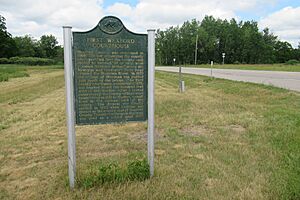
By 1968, Sherman had only one grocery store and a gas station. The spot where the old courthouse stood is now a Michigan State Historic Site. A marker was placed there on February 28, 1969, to remember the first Wexford Courthouse. Another marker about the "Battle of Manton" was placed in Manton on June 18, 1970.
Today, Sherman is still an unincorporated community north of Mesick along M-37. It has a small number of permanent residents and a few small businesses. Because of its decline after the 1920s, some people might even consider it a ghost town.
Notable People from Sherman
- Ed Wheeler: A professional baseball player for the Brooklyn Superbas in 1902. He was born in Sherman.


