
Sierra de Guadalupe, Mexico facts for kids
Quick facts for kids Sierra de Guadalupe |
|
|---|---|

Highest point as seen from Coacalco
|
|
| Highest point | |
| Peak | Picacho Moctezuma |
| Elevation | 3,055 m (10,023 ft) |
| Dimensions | |
| Length | 25 km (16 mi) W x E |
| Width | 8 km (5.0 mi) N × S |
| Geography | |
 |
|
| Country | Mexico |
| State | State of Mexico Mexico City |
| Region | Central Mexico |
| Geology | |
| Volcanic arc/belt | Trans-Mexican Volcanic Belt |
The Sierra de Guadalupe is a mountain range in Mexico. It is located between the northern part of Mexico City (in the Gustavo A. Madero area) and several towns in the State of Mexico. These towns include Cuautitlán Izcalli, Tultitlán, Coacalco, Ecatepec, and Tlalnepantla. The highest point of the Sierra de Guadalupe is about 3,055 meters (10,023 feet) tall.
Contents
History of the Sierra de Guadalupe

Long ago, the Aztecs believed that Tepeyac hill, which is part of the Sierra de Guadalupe, was a special place. They worshipped a goddess named Tonantzin there. She was known as the Goddess of Sustenance, meaning she helped provide food and life.
The mountain range gets its name from Our Lady of Guadalupe. This is a famous story about a vision that Juan Diego saw on Tepeyac hill. This happened a long time ago, and the story is found in old writings like the Huei tlamahuiçoltica.
Later, in 1937, a special area called the El Tepeyac National Park was created. This park is on Tepeyac hill, in the eastern part of the Sierra. It was made a national park by President Lázaro Cárdenas to protect the area.
Geology of the Mountains
The Sierra de Guadalupe is actually a dormant volcano. This means it is a volcano that is not active right now but could become active again in the future. It is part of a larger chain of volcanoes called the Trans-Mexican Volcanic Belt.
The ground in the Sierra is made of special types of rock called andesitic and dacitic soil. Scientists believe that the last time this volcano was active was about 14 to 15 million years ago. That's a very long time!
Nature and Wildlife

Climate in the Sierra
The Sierra de Guadalupe has a humid subtropical climate. This means it's usually warm and gets a lot of rain, especially during the summer months. About 700 to 800 millimeters (27 to 31 inches) of rain falls each year.
The temperature in the Sierra usually stays between 12 and 16 degrees Celsius (53 to 60 degrees Fahrenheit). This makes it a comfortable place for many plants and animals to live.
Animals of the Sierra
Many different animals call the Sierra de Guadalupe home. You might find the Mexican pine snake slithering through the plants. Birds like the American kestrel and the speedy roadrunner fly through the skies.
Other animals include the clever opossum and the wild bobcat. Some animals, like the white-tailed deer, have also been brought into the area.
Plants of the Sierra
The Sierra de Guadalupe is full of interesting plants. You can find many quercus trees, which are also known as oak trees. There are also many xerophile plants. These are special plants that are very good at living in dry places.
Protecting the Environment
Sadly, the Sierra de Guadalupe has faced some problems. One big issue is deforestation, which means many trees have been cut down. This harms the environment and the animals that live there.
To help fix this, parts of the eastern Sierra have been reforested. This means new trees have been planted. Some of the trees planted include eucalyptus, pinus (pine trees), cedrus (cedar trees), and casuarina trees. These efforts help to bring back the natural beauty and health of the mountain range.
Hills of the Sierra
The Sierra de Guadalupe is made up of several different hills. Here are some of them:
- Cerro del Sombrero or Pico Tres Padres
- Cerro de los Gachupines (2,330 m)
- Cerro del Chiquihuite (2,730 m)
- Cerro del Picacho Moctezuma (3,055 m)
- Cerro del Picacho El Fraile (2,902 m)
- Cerro del Picacho El Jaral
- Cerro del Tenayo
- Cerro Petlecatl
- Cerro de la Calavera
- Cerro Gordo
- Cerro Zacatenco (2,500 m)
- Cerro del Guerrero (2,440 m)
- Cerro de Santa Isabel
- Cerro del Tepeyac (2,270 m)
Gallery
-
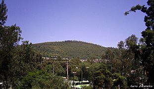
Cerro Zacatenco
-
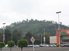
Cerro Los Gachupines
-
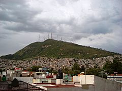
Cerro del Chiquihuite
-
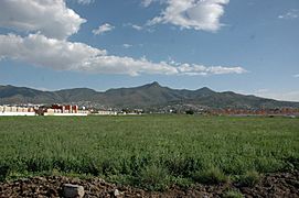
Wider view


See also
 In Spanish: Sierra de Guadalupe (México) para niños
