Silurian Hills facts for kids
Quick facts for kids Silurian Hills |
|
|---|---|

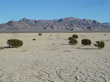
View of Silurian Hills beyond Silurian Dry Lake, and the occasional creosote bush.
|
|
| Highest point | |
| Elevation | 1,056 ft (322 m) |
| Geography | |
| Country | United States |
| State | California |
| Region | Mojave Desert |
| District | San Bernardino County |
| Range coordinates | 35°31′59.912″N 116°7′38.059″W / 35.53330889°N 116.12723861°W |
| Topo map | USGS Silurian Lake |
The Silurian Hills are a small group of hills in the Mojave Desert. This desert is located in southern California, southeast of Death Valley National Park. The flat lands around these hills are very important. They help animals move safely between different mountain ranges nearby.
This area is a vital home and travel path for many animals. These include bighorn sheep, desert tortoises, and kit foxes. Golden eagles also build their nests here, and burrowing owls live in the ground. The Silurian Valley, which is mostly untouched, helps keep these animals safe. It is a key link for this part of the northern Mojave Desert.
Contents
Exploring the Silurian Hills: Location and Size
The Silurian Hills stretch from the northwest to the southeast. They are about 9 miles (14 kilometers) long. To the east, you will find the Shadow Mountains. To the west, across the Silurian Valley, are the Avawatz Mountains.
Waterways and Neighboring Ranges
Salt Creek flows through the Silurian Valley, which is about 19 miles (30 kilometers) long. This creek does not always have water, but when it does, it connects Silver Lake in the south to Death Valley in the north. Other mountain ranges close by include the Salt Spring Hills and the Sperry Hills.
Places to See Near Silurian Hills
Highway 127 runs through the Silurian Valley. This road goes from the northwest to the southeast. It connects three important protected areas. These are Joshua Tree National Park, the Mojave National Preserve, and Death Valley National Park. Many people think this part of Highway 127 is one of the most beautiful roads in California.
Nearby Communities and Historic Trails
The small town of Halloran Springs is about 12 miles (19 kilometers) to the southeast. It is located near Interstate 15. The historic Old Spanish Trail also passed through this area. This old trade route had different paths to find better water or to make the journey shorter. One of these paths, called the Kingston Cutoff, went southwest from Mountain Springs, Nevada, to Silurian Lake.
 | Georgia Louise Harris Brown |
 | Julian Abele |
 | Norma Merrick Sklarek |
 | William Sidney Pittman |


