Snells Beach facts for kids
Quick facts for kids
Snells Beach
|
|
|---|---|

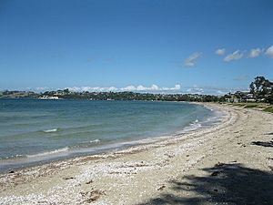
Snells Beach from northern end
|
|
| Country | New Zealand |
| Region | Auckland Region |
| Ward | Rodney ward |
| Local board | Rodney Local Board |
| Subdivision | Warkworth subdivision |
| Electorates |
|
| Area | |
| • Total | 3.83 km2 (1.48 sq mi) |
| Population
(June 2023)
|
|
| • Total | 3,810 |
| • Density | 994.8/km2 (2,576/sq mi) |
| Postcode(s) |
0982
|
Snells Beach is a small town on the coast in the north of the Auckland Region in New Zealand. It is located on the eastern side of the Mahurangi Peninsula. The town's beach faces east across Kawau Bay towards Kawau Island. The closest town is Warkworth, which is about 8 kilometers (5 miles) to the west. You can easily travel between Snells Beach and Warkworth by bus.
Contents
Geography of Snells Beach
Snells Beach is located on a narrow strip of land called an isthmus. This land connects the wider Mahurangi Peninsula to the mainland. It sits between the Mahurangi Harbour and Kawau Bay, which is part of the Hauraki Gulf. The town is about 8 kilometers (5 miles) east of Warkworth. It is also close to the small towns of Sandspit and Algies Bay.
The shallow waters near Snells Beach have important seagrass meadows. These seagrass beds help protect the beach from strong waves. They also provide a vital food source for many native animals that live in or visit the shoreline.
History of Snells Beach
Māori History
People have lived in the wider Mahurangi area since at least the 1200s. One of the first known iwi (tribes) to settle here was Ngāi Tāhuhu. Important canoes like Te Arawa and Tainui visited the area. Descendants of Manaia, captain of the Māhuhu-ki-te-rangi canoe, married into Ngāi Tāhuhu.
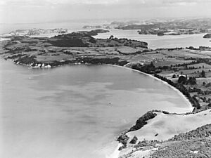
The Māori people of Mahurangi mainly settled along the shores of the Hauraki Gulf. They moved between different kāinga (villages) depending on where seasonal food was available. Snells Beach and nearby Algies Bay (called Horahorawai in Māori) were protected by pā (fortified villages) on the headlands. These pā looked out towards Kawau Island and Kawau Bay (called Moanauriuri), which was an important place for catching sharks. Old shell middens (piles of discarded shells) and terraces have been found near the headlands of Snells Beach.
By the mid-1700s, Marutūāhu tribes from the Hauraki Gulf, especially Ngāti Pāoa, wanted to control the shark fishing grounds along the Mahurangi coast. This led to wars between Ngāti Pāoa and the local Kawerau hapū (sub-tribes). By the early 1800s, Kawerau-descended hapū had rights to the land in Mahurangi. Fishing rights were shared between these hapū and the Marutūāhu tribes. At this time, the Mahurangi Harbour was mainly settled by Ngāti Rongo and their related hapū, Ngāti Kā and Ngāti Raupō. These groups had strong connections to Ngāti Manuhiri. Marutūāhu tribes often visited the coast during summer.
In the early 1820s, during the Musket Wars, Ngāpuhi and other northern tribes attacked settlements in the Mahurangi area. This caused many people to leave the Mahurangi area. Ngāti Rongo, Ngāti Raupō, and Ngāti Mahuhiri found safety with different tribes in Northland. Ngāti Rongo returned to Mahurangi in 1836, led by Te Hēmara Tauhia. They settled at Te Muri. By the late 1830s or early 1840s, Ngāti Rongo, Ngāti Raupō, and Ngāti Mahuhiri had all returned. During this time, many Kawerau hapū had also formed connections with Ngāti Whātua. The Mahurangi area was a place where Kawerau, Ngāti Whātua, and Marutūāhu tribes all had claims.
European Settlement
After the Treaty of Waitangi was signed in 1840, the Crown bought the Mahurangi and Omaha land blocks on April 13, 1841. Some iwi and hapū with traditional interests, like Ngāti Paoa, were involved. However, Ngāti Rongo, Ngāti Raupō, and Ngāti Manuhiri were not part of this first deal. It took until the 1850s for the Crown to finalize agreements with these tribes.
Early European settlers called the area Long Beach. In 1854, a Cornish miner named James Snell bought the land. He had first settled on Kawau Island after working in mines in South Australia. Snell settled at the beach, and his family farmed there for many generations. A Scottish immigrant, Alexander Algie, and his wife Mina, bought land to the south at Martins Bay. Alexander's brother Samuel settled there in 1867. The Algie family opened a boarding house on the beach in the late 1890s, which stayed open until 1941.
In 1904, J. Clayden and J. Parkinson found a large amount of kauri gum at Snells Beach. They dug up seven tons of it during low tide. More digging happened in 1907, mostly by new immigrants from Dalmatia. By the early 1900s, Snells Beach became a popular place for holidays. In the 1930s, a metal road was built along the Mahurangi Peninsula, making it easier to reach from Auckland.
The first group of shops in Snells Beach was built in 1982. The shops and light industrial area made Snells Beach a service center for the wider Mahurangi Peninsula. It became the second largest business area in the Warkworth/Matakana region. In the 2010s, Snells Beach changed from being mainly a holiday town to a place where people live permanently, like a smaller town connected to Warkworth. In 2012, the Snells Beach library was planned for closure, which made many residents upset.
Population and People
Snells Beach is considered a small urban area by Statistics New Zealand. It covers about 3.83 square kilometers (1.48 square miles). In the 2023 New Zealand census, Snells Beach had a population of 3,678 people. This was an increase of 273 people (8.0%) since the 2018 census.
The median age in Snells Beach was 48.1 years. About 17.8% of the people were under 15 years old. Most residents, 90.0%, identified as European (Pākehā). About 10.8% identified as Māori. English was spoken by 98.0% of the people. About 27.7% of the people were born overseas.
When it came to religion, 34.2% of people identified as Christian. A large number, 54.2%, said they had no religion.
Things to Do and See
The beach at Snells Beach is about 2.5 kilometers (1.5 miles) long. It is a tidal sandy beach, meaning the water level changes with the tides. Many shorebirds visit the beach. It is a popular spot for kite surfing, paddle boarding, swimming, and fishing. People also enjoy walking their dogs here.
The esplanade (a long, open, level area) along the beach is lined with pohutukawa trees. It has footpaths, playgrounds, and picnic areas. There is also a public barbecue, a waterfront café, public toilets, and showers. For boats, there are boat ramps. Motorhomes can park overnight for free.
The Mahurangi Shopping Centre has cafés, shops, public toilets, and Wifi. It also offers overnight parking for motorhomes. Next to the shopping center is Goodalls Reserve. This reserve has a community center, a library, a bowling club, a tennis club, a kindergarten, a skate park, sports fields, and walking tracks. There is also an area for dogs to exercise. Nearby, you can find a petrol station, two motels, and several bed and breakfast places.
The Brick Bay Sculpture Trail is located at the western entrance to Snells Beach. This is an outdoor art gallery where you can see modern sculptures. They are placed among native trees, palms, and birdlife. Snells Beach is also home to Family TV, the regional television broadcaster for the Rodney District.
Education in Snells Beach
Snells Beach has two main schools:
- Snells Beach Primary: This is a coeducational primary school for students in years 1-6 (ages 5-11). It opened in 2009 and is planned to grow to about 500 students. As of February 2024, it had 357 students.
- Horizon School: This school used to be called Mahurangi Christian School. It is a coeducational full primary school for years 1-8 (ages 5-13). It is a state-integrated school. As of February 2024, it had 238 students.
 | Ernest Everett Just |
 | Mary Jackson |
 | Emmett Chappelle |
 | Marie Maynard Daly |


