
Morris, Connecticut facts for kids
Quick facts for kids
Morris, Connecticut
|
||
|---|---|---|
| Town of Morris | ||

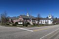
Morris Community Hall
|
||
|
||
 Litchfield County and Connecticut Litchfield County and Connecticut Northwest Hills Planning Region and Connecticut Northwest Hills Planning Region and Connecticut |
||
| Country | ||
| U.S. state | ||
| County | Litchfield | |
| Region | Northwest Hills | |
| Settled 1723 | Incorporated 1859 | |
| Government | ||
| • Type | Selectman-town meeting | |
| Area | ||
| • Total | 18.7 sq mi (48.5 km2) | |
| • Land | 17.3 sq mi (44.9 km2) | |
| • Water | 1.4 sq mi (3.6 km2) | |
| Elevation | 994 ft (303 m) | |
| Population
(2020)
|
||
| • Total | 2,256 | |
| • Density | 120.47/sq mi (46.52/km2) | |
| Time zone | UTC−5 (Eastern) | |
| • Summer (DST) | UTC−4 (Eastern) | |
| ZIP code |
06763
|
|
| Area code(s) | 860/959 | |
| FIPS code | 09-49460 | |
| GNIS feature ID | 0213465 | |

Morris is a small and charming town located in Litchfield County, Connecticut, United States. In 2020, about 2,256 people lived here. It's part of the Northwest Hills Planning Region, an area known for its beautiful scenery.
People from Europe first started settling in the Morris area around 1723. It was originally part of the town of Litchfield. Because it was about 5 miles south of Litchfield's center, it was called "South Farms." In 1767, it became its own church district. Then, in 1859, it officially became a separate town. It was named after James Morris, a local hero. He was a graduate of Yale University, an officer in the Revolutionary War, and he started one of the first schools in the country that allowed both boys and girls to attend.
Morris is located in a hilly area with lots of woods, wetlands, fields, and ponds. It also includes a large part of Bantam Lake, which was originally called the Great Pond. This lake covers about 947 acres and is the biggest natural lake in Connecticut. The town's official seal even shows a pine tree from Lone Tree Hill, which looks out over the lake. Morris is special because it has one of Connecticut's oldest state parks and also one of its newest.
Over time, Morris changed from a farming settlement in the 1700s to a mix of rural and modern life today. In the 1800s, farming became a business. But as time went on, it became harder for farms to make enough money. Small local businesses also faced challenges and many moved to bigger nearby cities like Waterbury and Torrington.
By the 1970s and 1980s, Morris was still mostly rural. However, people started working in many different jobs. Today, farming is still a tradition, but residents also work in various professions, businesses, and arts. Many people who own second homes in Morris come from the New York City area. Besides the two state parks and Bantam Lake, the White Memorial Conservation Center offers 4,000 acres for outdoor activities. Camp Washington is a spiritual retreat run by the Episcopal Diocese of Connecticut.
The center of Morris looks like a classic small New England village. It has a white Congregational church, a school, and a town hall. Homes, both old and new, are spread out along the roads, mixed with fields and woods. Children in Morris attend the local James Morris Elementary School and Wamogo High School. Wamogo High School is recognized as a "school of excellence" by the U.S. Department of Education. Interestingly, Morris also has a Buddhist temple and a Jewish cemetery from the early 1900s.
Contents
History of Morris, Connecticut
Morris was first settled around 1723. In 1767, it was set up as the South Farms church district of Litchfield. Morris started as a farming community. It became its own town in 1859. The town was named after James Morris (1752–1820). He was a soldier in the Revolutionary War. In 1790, he opened an academy (a type of school) in town. The old ruins of his academy are next to the current James Morris Elementary School. Morris played a role in the Revolutionary War. Many homes in Morris were used to house soldiers from Maine and Vermont as they traveled south to battles in New York.
Geography of Morris
Morris is located in Litchfield County. According to the United States Census Bureau, the town covers a total area of about 18.7 square miles (48.5 square kilometers). Most of this area, about 17.2 square miles (44.9 square kilometers), is land. The remaining 1.5 square miles (3.6 square kilometers) is water, which makes up about 8.17% of the town's total area.
Main Areas in Morris
Morris has a few distinct areas within its borders:
- Lakeside
- Morris center
- West Morris
- East Morris
Population and People of Morris
Morris has seen its population change over the years. Here's how many people have lived in Morris during different census years:
| Historical population | |||
|---|---|---|---|
| Census | Pop. | %± | |
| 1860 | 769 | — | |
| 1870 | 701 | −8.8% | |
| 1880 | 627 | −10.6% | |
| 1890 | 584 | −6.9% | |
| 1900 | 535 | −8.4% | |
| 1910 | 681 | 27.3% | |
| 1920 | 499 | −26.7% | |
| 1930 | 481 | −3.6% | |
| 1940 | 606 | 26.0% | |
| 1950 | 799 | 31.8% | |
| 1960 | 1,190 | 48.9% | |
| 1970 | 1,609 | 35.2% | |
| 1980 | 1,899 | 18.0% | |
| 1990 | 2,039 | 7.4% | |
| 2000 | 2,301 | 12.8% | |
| 2010 | 2,388 | 3.8% | |
| 2020 | 2,256 | −5.5% | |
| U.S. Decennial Census | |||
In 2000, there were 2,301 people living in Morris. There were 912 households and 640 families. The population density was about 133.9 people per square mile (51.7 people per square kilometer). Most of the people living in Morris were White (97.48%). A small percentage were African American (0.70%), Native American (0.13%), or Asian (0.83%). About 0.87% of the population identified as Hispanic or Latino.
About 31.6% of households had children under 18 living with them. Most households (60.2%) were married couples. The average household had 2.52 people, and the average family had 3.03 people.
The age breakdown in Morris in 2000 was:
- 24.6% were under 18 years old.
- 4.9% were between 18 and 24.
- 28.4% were between 25 and 44.
- 27.9% were between 45 and 64.
- 14.2% were 65 years or older.
The average age in town was 41 years.
Voter Registration in Morris
As of October 25, 2005, here's how people in Morris were registered to vote:
| Voter registration and party enrollment as of October 25, 2005 | |||||
|---|---|---|---|---|---|
| Party | Active voters | Inactive voters | Total voters | Percentage | |
| Republican | 653 | 8 | 661 | 40.01% | |
| Democratic | 339 | 2 | 341 | 20.64% | |
| Unaffiliated | 639 | 11 | 650 | 39.35% | |
| Minor Parties | 0 | 0 | 0 | 0.0% | |
| Total | 1,631 | 21 | 1,652 | 100% | |
Transportation in Morris
Morris has several main roads that help people get around. These roads connect Morris to other towns and areas.
North-South Roads
- Route 63: This road is on the east side of town. It goes north from East Morris to Litchfield and south to Watertown.
- Route 61: This road starts in Morris center. It goes north for a short distance before turning east on County Road to connect with Route 63 towards Litchfield. It also goes south from the center on South Street to Bethlehem.
- Route 209: Also known as Bantam Lake Road, this route runs north-south through Lakeside, along the western shore of Bantam Lake. It connects Route 109 and Route 202.
East-West Roads
- Route 109: This road goes east from Morris center on East Street. It passes through East Morris, crosses Route 63, and continues as Thomaston Road, ending in Thomaston. Heading west from Morris center on West Street, it goes through Lakeside and West Morris to Washington Depot.
- U.S. Route 202: This major route runs through the northwest corner of Morris. It connects Litchfield and New Milford.
Places to Visit in Morris
Morris is home to many interesting and fun places:
- Bantam Lake: This is the largest natural lake in Connecticut. It's a popular spot for recreation and is home to the oldest water ski club in America.
- Camp Columbia State Park/State Forest: One of Connecticut's newest state parks, offering outdoor activities.
- Camp Washington: A summer camp for both boys and girls, and a retreat center for the Episcopal Diocese of Connecticut.
- Mattatuck Trail: A hiking trail that offers a medium difficulty level. It stretches from Warren to Waterbury.
- Mount Tom State Park: This park is located in Morris, Litchfield, and Washington. The summit of Mount Tom (981 feet or 299 meters) and its tower are in Morris.
- South Farms: A registered historic farm that is now a popular venue for events.
- White Memorial Foundation: A large nature sanctuary covering 4,000 acres, located in Morris and Litchfield. It's a great place for nature lovers.
- Winvian: A luxury hotel and resort.
Famous People from Morris
Many notable individuals have connections to Morris, Connecticut:
- Chuck Aleksinas (born 1959): A basketball player drafted by the Chicago Bulls. He played for the Golden State Warriors and was a star player at Wamogo High School and UConn.
- P.T. Barnum (1810–1891): A famous showman and businessman. He owned a copper mine in East Morris that was not successful.
- John Brown (1800–1859): A well-known abolitionist who fought against slavery. He was a student at Morris Academy.
- Alexander Hamilton Holley (1804–1887): A student at Morris Academy who later became the 40th Governor of Connecticut.
- Sally May Johnson (1880–1957): A pioneering nurse who was Chief Nurse at the Army School of Nursing during World War I.
- James Morris (1752–1820): The town of Morris is named after him. He was a Revolutionary War officer and founded one of the first coeducational schools in the nation.
- John Mason Peck (1789–1858): A Baptist minister and missionary who was educated at Morris Academy.
- Winthrop H. Smith (1893–1961): A successful investment banker and a name partner of Merrill Lynch.
Images for kids
-
Morris Community Hall
-
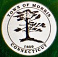
Seal of the Town of Morris
-
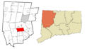
Morris' location within Litchfield County and Connecticut
-
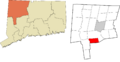
Morris' location within the Northwest Hills Planning Region and Connecticut
See also
 In Spanish: Morris (Connecticut) para niños
