Sprague, Washington facts for kids
Quick facts for kids
Sprague
|
|
|---|---|
| Sprague, Washington | |
 |
|

Location of Sprague, Washington
|
|
| Country | United States |
| State | Washington |
| County | Lincoln |
| Area | |
| • Total | 1.05 sq mi (2.72 km2) |
| • Land | 1.05 sq mi (2.72 km2) |
| • Water | 0.00 sq mi (0.00 km2) |
| Elevation | 1,903 ft (580 m) |
| Population
(2020)
|
|
| • Total | 495 |
| • Density | 471.4/sq mi (182.0/km2) |
| Time zone | UTC-8 (Pacific (PST)) |
| • Summer (DST) | UTC-7 (PDT) |
| ZIP code |
99032
|
| Area code(s) | 509 |
| FIPS code | 53-67175 |
| GNIS feature ID | 1508614 |
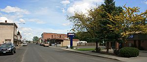
Sprague (pronounced sprayg) is a small city in Lincoln County, Washington, United States. In 2020, about 495 people lived there. The city was planned in 1880. It was named after John Wilson Sprague, a general from the American Civil War.
Contents
History of Sprague
Sprague was first settled by a man named William Newman. He built an inn in the area.
The city of Sprague officially became a city on November 28, 1883. It was first called Hoodooville. This name came from a local person known as Hoodoo Billy. Later, the name was changed to honor General John W. Sprague. He was an important leader in the railroad business.
What Happened in 1895?
A big fire destroyed Sprague on August 3, 1895. After the fire, the Northern Pacific Railroad decided not to rebuild in the town. This decision had a major effect on Sprague.
Sprague had been the county seat since 1884. A county seat is the main town where the county government is located. Because of the fire and the railroad's decision, the county seat moved. It was relocated to Davenport in 1896 after a vote.
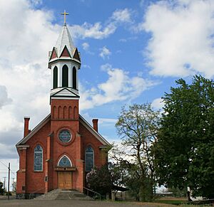
Mary Queen of Heaven Catholic Church
The Mary Queen of Heaven Catholic Church in Sprague was first built in 1883. The church you see today was built in 1902. It has a beautiful Gothic Revival style. It was built just south of where the first church stood.
A bishop from the Diocese of Nesqually blessed the new church. In 1990, the U.S. Department of Interior added it to the National Register of Historic Places. This means it is an important historical building.
Where is Sprague Located?
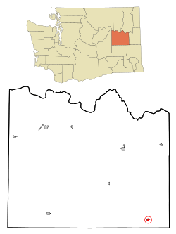
Sprague is found at coordinates 47°17′56″N 117°58′39″W / 47.29889°N 117.97750°W. It is where Interstate 90 and State Route 23 meet. The city is northeast of Sprague Lake.
It is about 23 miles (37 km) from Ritzville. Sprague is also about 36 miles (58 km) from Spokane. The United States Census Bureau says the city covers about 0.63 square miles (1.63 square kilometers). All of this area is land.
What is the Climate Like in Sprague?
Sprague has a climate that is a mix of two types. It is between a dry-summer humid continental climate and a semi-arid climate. This means it has warm, dry summers and cold winters.
| Climate data for Sprague | |||||||||||||
|---|---|---|---|---|---|---|---|---|---|---|---|---|---|
| Month | Jan | Feb | Mar | Apr | May | Jun | Jul | Aug | Sep | Oct | Nov | Dec | Year |
| Record high °F (°C) | 59 (15) |
64 (18) |
75 (24) |
90 (32) |
99 (37) |
106 (41) |
109 (43) |
110 (43) |
102 (39) |
92 (33) |
72 (22) |
62 (17) |
110 (43) |
| Mean daily maximum °F (°C) | 34.1 (1.2) |
41.6 (5.3) |
51.1 (10.6) |
60.8 (16.0) |
70 (21) |
77.6 (25.3) |
87.1 (30.6) |
85.7 (29.8) |
76.3 (24.6) |
62.4 (16.9) |
45.4 (7.4) |
37.4 (3.0) |
60.8 (16.0) |
| Mean daily minimum °F (°C) | 18.7 (−7.4) |
24.7 (−4.1) |
29 (−2) |
34.1 (1.2) |
40.7 (4.8) |
46.7 (8.2) |
51.1 (10.6) |
49.3 (9.6) |
42.4 (5.8) |
34.3 (1.3) |
27.8 (−2.3) |
23.4 (−4.8) |
35.2 (1.8) |
| Record low °F (°C) | −31 (−35) |
−33 (−36) |
0 (−18) |
14 (−10) |
21 (−6) |
27 (−3) |
31 (−1) |
31 (−1) |
20 (−7) |
4 (−16) |
−15 (−26) |
−21 (−29) |
−33 (−36) |
| Average precipitation inches (mm) | 1.74 (44) |
1.45 (37) |
1.26 (32) |
1.03 (26) |
1.10 (28) |
1.00 (25) |
0.43 (11) |
0.47 (12) |
0.77 (20) |
1.18 (30) |
2.02 (51) |
2.03 (52) |
14.48 (368) |
| Average snowfall inches (cm) | 8.3 (21) |
3.8 (9.7) |
1.4 (3.6) |
0.1 (0.25) |
0 (0) |
0 (0) |
0 (0) |
0 (0) |
0 (0) |
0.1 (0.25) |
2.6 (6.6) |
6.5 (17) |
22.9 (58) |
| Average precipitation days | 10 | 8 | 8 | 6 | 7 | 6 | 3 | 3 | 4 | 7 | 10 | 11 | 83 |
Population of Sprague
| Historical population | |||
|---|---|---|---|
| Census | Pop. | %± | |
| 1890 | 1,689 | — | |
| 1900 | 695 | −58.9% | |
| 1910 | 1,110 | 59.7% | |
| 1920 | 822 | −25.9% | |
| 1930 | 639 | −22.3% | |
| 1940 | 641 | 0.3% | |
| 1950 | 598 | −6.7% | |
| 1960 | 597 | −0.2% | |
| 1970 | 550 | −7.9% | |
| 1980 | 473 | −14.0% | |
| 1990 | 410 | −13.3% | |
| 2000 | 490 | 19.5% | |
| 2010 | 446 | −9.0% | |
| 2020 | 495 | 11.0% | |
| U.S. Decennial Census 2020 Census |
|||
Sprague in 2010
According to the 2010 census, Sprague had 447 people. There were 197 households and 128 families living in the city. The city had about 708 people per square mile (273 people per square kilometer).
Most people in Sprague were White (94.2%). There were also Native American (2.0%), Asian (1.6%), and other races. About 3.6% of the population was Hispanic or Latino.
About 26.4% of households had children under 18. Many households (51.8%) were married couples. Some households had a female (9.1%) or male (4.1%) head without a spouse. About 32.5% of households had people living alone.
The average age in Sprague was 46.5 years. About 23.1% of residents were under 18. About 19.5% were 65 years or older. The population was almost evenly split between males (51.1%) and females (48.9%).
Famous People from Sprague
- Scott Buchanan (1895-1968), a well-known American thinker and teacher.
- Eugene E. Lindsey, a brave naval pilot during World War II.
- Mary Carolyn Davies (1888-1974), a poet and writer. She wrote "A Casualty List" in 1918.
See also
 In Spanish: Sprague (Washington) para niños
 | John T. Biggers |
 | Thomas Blackshear |
 | Mark Bradford |
 | Beverly Buchanan |


