St. Thomas Township, Pennsylvania facts for kids
Quick facts for kids
St. Thomas Township
|
|
|---|---|
|
Township
|
|

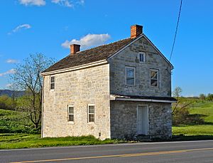
The Toll House along U.S. Route 30
|
|

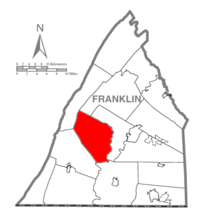
Map of Franklin County, Pennsylvania highlighting St. Thomas Township
|
|

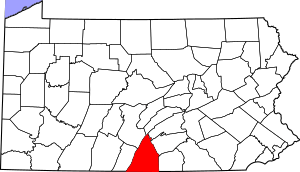
Map of Franklin County, Pennsylvania
|
|
| Country | United States |
| State | Pennsylvania |
| County | Franklin |
| Settled | 1731 |
| Incorporated | 1818 |
| Area | |
| • Total | 51.90 sq mi (134.41 km2) |
| • Land | 51.87 sq mi (134.33 km2) |
| • Water | 0.03 sq mi (0.08 km2) |
| Population
(2020)
|
|
| • Total | 5,917 |
| • Estimate
(2016)
|
5,978 |
| • Density | 115.26/sq mi (44.50/km2) |
| Time zone | UTC-5 (Eastern (EST)) |
| • Summer (DST) | UTC-4 (EDT) |
| Area code(s) | 717 |
| FIPS code | 42-055-67400 |
St. Thomas Township is a community located in Franklin County, Pennsylvania, in the United States. It is a type of local government area called a township. In 2020, about 5,917 people lived here.
This township is special because two famous people were born here. One is Nellie Fox, a baseball star who is in the Baseball Hall of Fame. The other is Charles Thomas Campbell, who was a brigadier general in the United States Army and also a lawmaker.
Contents
History of St. Thomas Township
The area where St. Thomas Township is located was first settled in the 1740s. Some of the early settlers included John Armstrong, John Campbell, and John Dixon. There were many families named Campbell living here. Because of this, an old map from the 1700s simply called the village "Campbells."
How the Township Got Its Name
Later, the village was known as "Campbelltown." This name was used for many years. Then, a person named William Archibald suggested a new name: "St. Thomas." This name was chosen to honor Thomas Campbell, who had helped plan the village. The name "Saint Thomas" was reportedly a playful joke about Thomas Campbell's personality.
When St. Thomas Township Was Formed
The exact records of when the township was officially formed were lost. This happened when the Confederates burned the county seat of Chambersburg in 1864 during the American Civil War. However, older residents remembered that the township was organized around 1818. It was created from parts of Peters and Hamilton townships.
Early Churches in the Township
The organization of the township happened at the same time as the St. Thomas or "Campbeltown" Presbyterian Church was formed in 1818. Not long after, local Evangelical Lutheran and German Reformed church groups joined the Presbyterians. They built a church building together. These three groups shared the church from 1829 until 1854.
Historic Places in St. Thomas Township
Several important historical sites in St. Thomas Township are listed on the National Register of Historic Places. These include the Franklin Furnace Historic District, the Chambersburg and Bedford Turnpike Road Company Toll House, and a place called Woodland. These places help preserve the history of the area.
Geography of St. Thomas Township
St. Thomas Township is located in the west-central part of Franklin County. It sits in a large area known as the Great Appalachian Valley. However, it also stretches northwest into the Ridge and Valley Province of the Appalachian Mountains.
Mountains and Waterways
The township includes four mountain ridges from east to west: Front Mountain, Broad Mountain, Little Mountain, and Blue Mountain.
The Conodoguinet Creek starts in the very western part of the township, where Little and Blue mountains meet. This creek flows into the Susquehanna River. Most of the rest of the township is drained by smaller streams that flow into Conococheague Creek. Conococheague Creek is part of the Potomac River watershed.
Main Roads and Communities
U.S. Route 30 is a major road that goes through the township. This road goes east to Chambersburg, which is the main town of the county. It goes west to McConnellsburg. U.S. Route 30 passes through the main community of St. Thomas, which is in the center of the township. Another community, Williamson, is in the southern part of the township.
Size of the Township
According to the United States Census Bureau, St. Thomas Township covers a total area of about 134.3 square kilometers (about 51.9 square miles). A very small part of this area, about 0.08 square kilometers (0.03 square miles), is water.
Neighboring Townships
St. Thomas Township shares its borders with several other townships:
- Antrim Township (to the southeast)
- Hamilton Township (mostly to the east)
- Letterkenny Township (to the north)
- Metal Township (to the northwest)
- Peters Township (to the west)
Communities in St. Thomas Township
St. Thomas Township is home to several smaller communities:
- Carlton Heights
- Edenville
- Franklin Furnace
- Saint Thomas
- Stone Bridge
- Williamson
Population of St. Thomas Township
| Historical population | |||
|---|---|---|---|
| Census | Pop. | %± | |
| 2000 | 5,775 | — | |
| 2010 | 5,935 | 2.8% | |
| 2020 | 5,917 | −0.3% | |
| 2016 (est.) | 5,978 | 0.7% | |
| U.S. Decennial Census | |||
In 2020, the population of St. Thomas Township was 5,917 people. The population has stayed fairly steady over the years. For example, in 2000, there were 5,775 people, and in 2010, there were 5,935 people.
Who Lives in St. Thomas Township?
In 2000, there were 2,141 households in the township. About 34% of these households had children under 18 living with them. The average household had about 2.68 people.
The population was spread out by age. About 25.4% of the people were under 18 years old. About 12.1% were 65 years or older. The average age of people in the township was 37 years.
See also
 In Spanish: Municipio de St. Thomas (Pensilvania) para niños
 | William Lucy |
 | Charles Hayes |
 | Cleveland Robinson |

