
Conococheague Creek facts for kids

The Conococheague Creek is a beautiful, free-flowing stream that starts in Pennsylvania and flows into the Potomac River near Williamsport, Maryland. A "tributary" is a smaller stream that flows into a larger river. This creek is about 80 miles (129 km) long. About 57 miles (92 km) of it are in Pennsylvania, and 23 miles (37 km) are in Maryland. The area of land where all the water drains into Conococheague Creek, called its "watershed," is about 566 square miles (1,466 sq km). Only a small part of this area, about 65 square miles (168 sq km), is in Maryland.
The name "Conococheague" comes from the Lenape Native American language. It means "many-turns-river," which describes how the creek winds and bends. In 1790, a law was passed about where the United States capital would be. The Conococheague was the northernmost point mentioned in this law. President George Washington later chose the area for the capital, Washington, D.C., further south.
The high ground that separates the water flowing into Conococheague Creek from the water flowing into Conodoguinet Creek is sometimes seen as the border between the Hagerstown Valley and the Cumberland Valley.
East Branch of Conococheague Creek

The main part of Conococheague Creek, before it meets its West Branch, is sometimes called the East Branch. This "East Branch" is about 53.1 miles (85.5 km) long. It starts in the South Mountain area of south-central Pennsylvania. It forms in northwestern Adams County, Pennsylvania, between East Big Flat Ridge and Piney Mountain.
The creek flows southwest, then turns west near Caledonia State Park. It continues past Fayetteville, Pennsylvania, and into the Great Appalachian Valley. It turns southwest again near Chambersburg, Pennsylvania, and flows west of Greencastle, Pennsylvania.
From Fayetteville to where it meets Back Creek near Williamson, the water quality of the creek is affected by things from farms. Over the last 30 years, there have been fewer native fish species, like yellow perch, eel, horned chub, calico bass, rock bass, and white sucker. This is partly because of sediment collecting on the bottom, which makes it harder for these fish to lay their eggs.
West Branch Conococheague Creek
The West Branch of Conococheague Creek is about 60.0 miles (96.6 km) long. It runs through almost all of western Franklin County, Pennsylvania. It joins the main branch near the town of Greencastle. This West Branch is generally cleaner than the East Branch. A large part of it flows through wilderness areas. This makes it a great place for fishing, especially for smallmouth bass, warmouth, and rock bass.
However, there are a few small water treatment plants on the lower part of the West Branch, starting at Fort Loudon, Pennsylvania. These plants can make it harder for native fish to lay their eggs in that area. Fish like Northern pike and pickerel have also been caught in this creek.
The West Branch flows southwest along the Tuscarora Trail to around Fort Loudon. Then it turns south, and finally southeast. It joins the main part of the creek about 5.1 miles (8.2 km) north of the Mason–Dixon line.
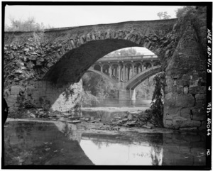
The Bridge in Metal Township crosses the West Branch Conococheague Creek in Metal Township, Franklin County, Pennsylvania. This bridge was added to the National Register of Historic Places in 1988.
Conococheague Creek in Maryland
Conococheague Creek continues south into Maryland. It flows into the Potomac River near Williamsport, Maryland. This area was historically important. The Great Wagon Road, a major travel route, crossed the Potomac River here at William's Ferry. From there, it continued on to Winchester, Virginia.
General Edward Braddock and his army also crossed the Potomac River at this spot. They were on their way to Winchester after leaving Frederick, Maryland. The Tuscarora Trail, a hiking path, also crosses the Conococheague Creek.
