Stapleton, Leicestershire facts for kids
Quick facts for kids Stapleton |
|
|---|---|
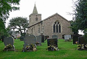
 Saint Martin's Church |
|
| Population | 427 (2001 census) |
| OS grid reference | SP434984 |
| Civil parish |
|
| District |
|
| Shire county | |
| Region | |
| Country | England |
| Sovereign state | United Kingdom |
| Post town | Leicester |
| Postcode district | LE9 |
| Dialling code | 01455 |
| Police | Leicestershire |
| Fire | Leicestershire |
| Ambulance | East Midlands |
| EU Parliament | East Midlands |
| UK Parliament |
|
Stapleton is a small village in Leicestershire, England. It is located in the south-west part of the county, about ten miles south-west of the city of Leicester. In 2001, about 427 people lived there.
Stapleton used to be a separate area called a "civil parish." A civil parish is a local government area. Now, Stapleton is part of a larger parish called Kirkby Mallory, Peckleton and Stapleton. It is also part of the Hinckley and Bosworth district.
Contents
Exploring Stapleton's Location
Stapleton is built on a long, raised area of land called a ridge. This ridge starts in a place called Barwell to the south. It then goes north, getting higher, until it reaches Osbaston. From there, the land slopes down towards a small river.
Rivers Near Stapleton
The closest major river to Stapleton is the River Sence. However, a smaller river called the River Tweed is even closer. A small stream that feeds into the River Tweed starts in the northern part of Stapleton. The main source of the River Tweed begins near Hinckley. It then flows north along the edge of Barwell before turning west and continuing north-east.
Stapleton's Rich History
The village of Stapleton has a very long history. It is centered around St. Martin's Church, which was built around the year 1300. This church is located on Church Lane, at the southern end of the village. It was likely an important stop for people traveling between Ashby-de-la-Zouch Castle and areas like Coventry, Warwick, and Kenilworth.
Early Mentions of Stapleton
The first time Stapleton is mentioned in writing was in the year 833. This was in a special document from King Wiglaf of Mercia. He was a king who ruled a part of England called Mercia a very long time ago. This document gave land in Stapleton and Sutton to a religious leader called the Abbot of Crowland.
Stapleton is also mentioned in the Domesday Book. The Domesday Book was a huge survey of England ordered by William the Conqueror in 1085. It recorded who owned land and what was on it after the Norman Conquest. The Domesday Book says that Stapleton had about five or six families living there. It also says that a powerful person named Hugh de Grandmesnil owned the village. He was given most of West Leicester by William the Conqueror after the Normans took over England.
 | William L. Dawson |
 | W. E. B. Du Bois |
 | Harry Belafonte |


