
Steeple Ashton facts for kids
Quick facts for kids Steeple Ashton |
|
|---|---|
 The village, seen from across a field |
|

Steeple Ashton
|
|
| Population | 1,221 (in 2021) |
| OS grid reference | ST907569 |
| Unitary authority |
|
| Ceremonial county | |
| Region | |
| Country | England |
| Sovereign state | United Kingdom |
| Post town | TROWBRIDGE |
| Postcode district | BA14 |
| Dialling code | 01380 |
| Police | Wiltshire |
| Fire | Wiltshire |
| Ambulance | Great Western |
| EU Parliament | South West England |
| UK Parliament |
|
Steeple Ashton is a lovely village in Wiltshire, England. It's about 3 miles (5 km) east of a bigger town called Trowbridge. A "civil parish" is like a small local area with its own council that helps run things for the people living there.
In the northern part of Steeple Ashton, you'll find two smaller areas called Ashton Common and Bullenhill.
The Story of Steeple Ashton
Steeple Ashton has a long and interesting history! Long ago, before the Dissolution of the Monasteries (when many religious places in England were closed down), Steeple Ashton was owned by Romsey Abbey. This abbey was a very important religious house. The village was also the main place for the local "hundred" (an old way of dividing land), where courts were held.
Why the Name "Steeple"?
The first part of the village's name, "Steeple," comes from a tall, pointed tower that used to be on the village church. This steeple was built around 1480–1500. Imagine how tall it was! In 1606, it was measured and found to be 32 yards (about 29 meters) taller than the church tower itself. This made the total height of the church about 186 feet (57 meters)!
Sadly, the steeple was hit by lightning in July 1670. Even after repairs, it was struck again in October of the same year. This second strike badly damaged the church, and two workers were even killed. After that, no one tried to rebuild the steeple.
A Busy Market Town
Steeple Ashton was once a busy market town. It was given permission to hold a weekly market way back in 1266. Today, you can still see a market cross (a stone pillar that marks where the market was held) on the village green. It's dated 1679.
In the early 1500s, a big fire hit the town. This fire especially affected the cloth-making industry, which was very important here. After the fire, many cloth businesses moved to nearby Trowbridge. Trowbridge had the River Biss, which was perfect for powering fulling mills (machines used to clean and thicken cloth). Because of this, the market business in Steeple Ashton also moved to other towns like Market Lavington.
Changes Over Time
The main road through Steeple Ashton used to connect Edington to Trowbridge. This road was part of a route from Salisbury, but it stopped being used much after the late 1700s.
In 1818, the parish of Steeple Ashton was much larger. It included areas like Great Hinton, Semington, and West Ashton. But later in the 1800s, these areas became their own separate parishes. This made Steeple Ashton parish much smaller.
In 1991, the village had 955 people. This number was lower than in 1981 because some new houses built near Trowbridge were moved into Trowbridge's parish. But by 2021, the population of Steeple Ashton had grown again to 1,221 people.
Places of Worship
Steeple Ashton has a beautiful old church and some other chapels.
The Parish Church of St Mary

The parish church of St Mary is truly special. Experts from Historic England call it "One of the finest Perpendicular churches in the country." Its grand design shows how wealthy Steeple Ashton was from its wool industry long ago. The famous historian Pevsner said the church "fairly bristles with pinnacles – a gay and fantastical sight."
There was a church here as early as 1252, and it was linked to Romsey Abbey until the abbey closed. The church you see today was mostly rebuilt in the late 1400s. It's made of limestone. The north side was paid for by Robert Long, and the south side by Walter Lucas, both important cloth merchants.
The church tower might have been built earlier, in the early 1400s. It used to have a stone spire that was 93 feet (28 meters) high. This made the total height of the church about 186 feet (57 meters), which was the second tallest in Wiltshire after Salisbury Cathedral. As mentioned before, the spire was hit by lightning twice in 1670 and was never replaced. The oldest part of the church, the chancel, was rebuilt in 1853 by Henry Clutton.
On the south side of the tower, there's a clock face from the 1800s. It's connected to an even older clock, possibly from 1543! All six of the church bells were remade in 1959.
Inside, the main part of the church (the nave) has a unique oak roof with a special design called a lierne vault. The windows in the side aisles and the Lady Chapel still have small pieces of medieval stained glass. People say these windows were broken during the English Civil War.
Famous Vicars
Some interesting people have been vicars (church leaders) at Steeple Ashton:
- George Webb (1605–1636): He wrote a book called The Practice of Quietness and later became a bishop.
- Henry Carpenter (1636–1660): He later became a Canon of Windsor.
- Samuel Hey (1787–1828): He was a tutor at Magdalene College, Cambridge. He left his personal library of about 175 books to the parish. Over time, this collection grew to over a thousand books! Today, about 250 books are kept in a room above the church porch, which is now called the Samuel Hey Library.
Church Parish Changes
Over the years, the church's parish boundaries have changed. In 1846, a new church was built in West Ashton, and that area became its own church district. In 1954, some land was moved to Trowbridge's parish, and some from Melksham was added to Steeple Ashton.
The church in Semington used to be part of Steeple Ashton's parish. The parish was even called "Steeple Ashton with Semington" until 2000, when Semington became its own independent parish. Today, Steeple Ashton is part of a group of churches that includes North Bradley, Southwick, and Heywood.
Other Chapels
- Baptists: People of the Baptist faith started meeting in Steeple Ashton in 1825. In 1864, they used a house on the village green as their chapel, which closed around 1940.
- Mormonism: The Mormon faith grew in the village after 1844. By 1851, about 50 people were meeting in a house. Many groups from Steeple Ashton even moved to America in that century.
- Primitive Methodists: A Primitive Methodist chapel was built in the village in 1854. It was updated in 1991 and is still used today as a Methodist church.
Village Life and Services
Steeple Ashton has some great local services for its residents.
There's a village hall where events and activities take place. There's also a village shop, which is run by helpful volunteers!
The Longs Arms is a public house (a pub) right in the middle of the village. It was built around 1700 and made bigger in the late 1800s. It's named after the Long family, who owned a lot of land in Steeple Ashton until 1930.
A school was built in 1828 by the Long family. In 1941, older students started going to schools in Trowbridge, and the village school became St. Mary's Church of England VA Primary School. This school closed in 2003, and most children then went to the school in Keevil.
Important Buildings and Sights
Steeple Ashton has many old and interesting buildings.
The manor house, which is a large historic home, is northeast of the church. It was built in 1647 for the Bennett family. The house and its land were bought in 1799 by Richard Long. It stayed in the Long family until the 1970s. In 1968, the house and its old granary (a building for storing grain) were given a special "Grade II* listed" status, meaning they are very important historic buildings.
The manor house was put up for sale in 2020 after being updated. It now has an atrium (a glass-covered space) that connects the main house to a courtyard. It has three living rooms, six bedrooms, and two bathrooms.
Five other houses in the parish are also Grade II* listed, including Ashton House (built around 1400) and Black Barn Cottage (from the 1400s).
On the small village green, you'll find two cool landmarks:
- A market cross from 1679. It's a stone column with a sundial and a ball on top.
- An 18th-century village lock-up. This was a small building used to temporarily hold people who had broken the law.
There's also a war memorial shaped like a cross on the High Street. In the churchyard, you can see a small green village pump made by a company called Lee Howl. You can also spot three old 1930s gas petrol pumps at a closed petrol station, and another older, more basic gas pump behind a gate.
Keevil Airfield
Right next to Steeple Ashton is Keevil Airfield. This was once a Royal Air Force base. During World War Two, it was used by American air forces. Later, it was a launch site for gliders that took part in important missions like the Normandy invasion of France and Operation Market Garden.
Even today, the Royal Air Force sometimes uses the airfield for military training. There's also a Gliding club there called Bannerdown Gliding Club, which is connected to RAF Brize Norton. So, you might see gliders flying high above!
Special Nature Area
To the southeast of Steeple Ashton, there's a special area of fields. This spot is important because it contains a bed of Jurassic coral limestone. In 1998, this area was named a Site of Special Scientific Interest (SSSI). This means it's a protected area because of its unique geology.
Images for kids
-
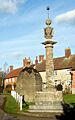
Market cross and lock-up, on the village green

See also
 In Spanish: Steeple Ashton para niños
